Enable Location

We need your location to show you interesting places around you

Discover nearby places

Find interesting locations and hidden gems around you

Precise directions

Get accurate directions and distances to places

Your location is never shared with other users. It's only used when you tap the location button.

Roddy Road Covered Bridge

Log in to your account

Join the adventure

Create your free account and start exploring (like 60k+ others)

We will send you a code to connect

or
Continue with Google
Continue with Apple
By continuing, you accept our Terms and Conditions and our Privacy Policy

Check your inbox

We've sent a pincode in your inbox. Please enter the code below.

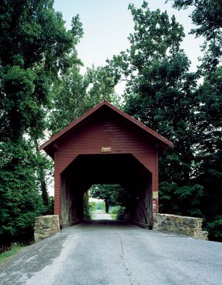
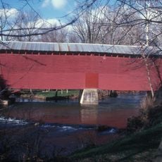
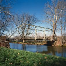
Roddy Road Covered Bridge, Covered bridge in Frederick County, United States.

Description

Roddy Road Covered Bridge is a wooden crossing over Owens Creek in Frederick County, Maryland, built with a simple post and beam design. The structure still carries traffic today and remains largely unchanged from its original construction method.

History

The bridge was built in 1892 using construction methods typical of that period in rural Maryland. It gained recognition on the National Register of Historic Places in 1978, acknowledging its place in the region's past.

Culture

The structure reflects how rural communities in the 1800s built their local infrastructure and shows the craftsmanship of builders from that era. Today it stands as a quiet reminder of how people moved through the countryside and connected different parts of their communities.

Practical

The bridge remains open to traffic and provides direct access across Owens Creek for local travel. Keep in mind this is an active roadway, so visitors should use caution and respect ongoing traffic patterns.

Did you know?

The bridge uses a simple post-based design that proved remarkably effective for its era and required minimal complex joinery. This straightforward approach allowed many rural communities to construct and maintain similar structures themselves.

Location
Inception
1892
GPS coordinates
39.64060,-77.39420
Latest update
December 14, 2025 12:27

AroundUs brings together thousands of curated places, local tips, and hidden gems, enriched daily by 60,000 contributors worldwide. Discover all places nearby (Frederick County).

Around this place
Cunningham Falls State Park
United States of America

Cunningham Falls State Park

6.7 km
Catoctin Mountain
United States of America

Catoctin Mountain

6.2 km
National Shrine of St. Elizabeth Ann Seton
United States of America

National Shrine of St. Elizabeth Ann Seton

8.4 km
St. Joseph's College and Mother Seton Shrine
United States of America

St. Joseph's College and Mother Seton Shrine

8.6 km
Catoctin Wildlife Preserve and Zoo
United States of America

Catoctin Wildlife Preserve and Zoo

6.3 km
Catoctin Furnace
United States of America

Catoctin Furnace

7.9 km
National Fallen Firefighters Memorial
United States of America

National Fallen Firefighters Memorial

8.4 km
Camp Misty Mount Historic District
United States of America

Camp Misty Mount Historic District

4.7 km
Camp Greentop Historic District
United States of America

Camp Greentop Historic District

7.2 km
LeGore Bridge
United States of America

LeGore Bridge

9.6 km
Victor Cullen Center, Old Administration Building
United States of America

Victor Cullen Center, Old Administration Building

9.5 km
Emmitsburg Historic District
United States of America

Emmitsburg Historic District

9.2 km
Strawberry Hill
United States of America

Strawberry Hill

8.5 km
Graceham Moravian Church and Parsonage
United States of America

Graceham Moravian Church and Parsonage

3 km
Fourpoints Bridge
United States of America

Fourpoints Bridge

8.7 km
Pennterra
United States of America

Pennterra

9.3 km
Victor Cullen School Power House
United States of America

Victor Cullen School Power House

10.1 km
St. John's Church at Creagerstown Historic District
United States of America

St. John's Church at Creagerstown Historic District

7.6 km
St. Euphemia's School and Sisters' House
United States of America

St. Euphemia's School and Sisters' House

9.3 km
Catoctin Mountain Park Visitor Center
United States of America

Catoctin Mountain Park Visitor Center

4.8 km
Loys Station Covered Bridge
United States of America

Loys Station Covered Bridge

5.1 km
Old Mill Road Bridge
United States of America

Old Mill Road Bridge

6.4 km
Chimney Rock
United States of America

Chimney Rock

3.6 km
Camp Round Meadow
United States of America

Camp Round Meadow

7.9 km
Camp Greentop
United States of America

Camp Greentop

7.1 km
Mt. Moriah Lutheran Church
United States of America

Mt. Moriah Lutheran Church

8.8 km
Catoctin Mountain Park Resource Management Office
United States of America

Catoctin Mountain Park Resource Management Office

7.8 km
Hunting Creek Lake
United States of America

Hunting Creek Lake

5.9 km
Show the full map
« Roddy Road Covered Bridge - Covered bridge in Frederick County, United States » is provided by Around Us (aroundus.com). Images and texts are derived from Wikimedia project under a Creative Commons license. You are allowed to copy, distribute, and modify copies of this page, under the conditions set by the license, as long as this note is clearly visible.

Discover hidden gems everywhere you go!

From secret cafés to breathtaking viewpoints, skip the crowded tourist spots and find places that match your style. Our app makes it easy with voice search, smart filtering, route optimization, and insider tips from travelers worldwide. Download now for the complete mobile experience.

Around Us App Screenshot

A unique approach to discovering new places

Le Figaro

All the places worth exploring

France Info

A tailor-made excursion in just a few clicks

20 Minutes

Around Us
Travel Guide & Maps
Download

Send to your phone

QR Code
1

Open the camera app on your mobile.

2

Point at the QR code with your camera. A notification will appear.

3

Tap the notification to open the link.