Enable Location

We need your location to show you interesting places around you

Discover nearby places

Find interesting locations and hidden gems around you

Precise directions

Get accurate directions and distances to places

Your location is never shared with other users. It's only used when you tap the location button.

Cunningham Falls State Park

Log in to your account

Start exploring — it's free

Trusted by 62,586 travelers worldwide

Continue with Google
Continue with Apple
or

We will send you a code to connect

By continuing, you accept our Terms and Conditions and our Privacy Policy

Check your inbox

We've sent a pincode in your inbox. Please enter the code below.

Cunningham Falls State Park, State park with waterfalls in Frederick County, United States.

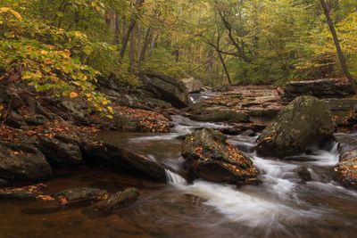
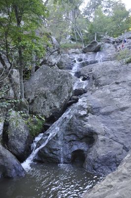
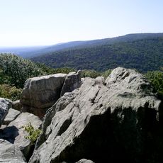
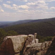
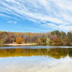
Cunningham Falls is a state park in Frederick County, Maryland, stretching across forested mountain slopes and valleys. The waterfall itself drops 24 meters (78 feet) over several rock ledges, forming clear water in the lower basin that pools between stones.

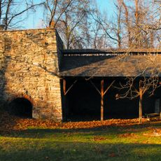
The grounds became a state park in the 1930s after the federal government acquired the land for recreation purposes. Iron production in the 19th century had previously cleared much of the original forest, which later regrew.

The park takes its name from photographer Cunningham, who documented the falls in the 19th century. Many families return each year to picnic at the same grilling areas or explore the same hiking trails.

The main trail to the waterfall is about one mile long and climbs gradually, making it manageable for most visitors. Summer weekends bring many people, so arriving earlier helps find more quiet.

The park borders Camp David, the presidential retreat, though visitors cannot see the boundary. The creek holds brook trout that are more active in cooler months and often visible in shallow sections.

The community of curious travelers

AroundUs brings together thousands of curated places, local tips, and hidden gems, enriched daily by 60,000 contributors worldwide.

Start exploring
Location
Inception
1954
Operator
Maryland Park Service
Address
14039 Catoctin Hollow Rd, Thurmont, MD 21788
GPS coordinates
39.59920,-77.45080
Latest update
December 20, 2025 11:49
Places to discover in Maryland: coast lighthouses, wildlife sanctuaries, waterfalls, and gardens

Maryland has many places to see away from the usual crowds. Natural areas fill the state: sanctuaries where birds and mammals live, waterfalls carving through forests, and coastlines with calm views over the water. History is everywhere: white lighthouses that guided ships for centuries, colonial...

Around this place
Camp David
United States of America

Camp David

5.6 km
Catoctin Mountain
United States of America

Catoctin Mountain

5.6 km
Catoctin Wildlife Preserve and Zoo
United States of America

Catoctin Wildlife Preserve and Zoo

1.9 km
Catoctin Furnace
United States of America

Catoctin Furnace

2.9 km
Camp Misty Mount Historic District
United States of America

Camp Misty Mount Historic District

4.8 km
Camp Greentop Historic District
United States of America

Camp Greentop Historic District

5.5 km
Graceham Moravian Church and Parsonage
United States of America

Graceham Moravian Church and Parsonage

6.5 km
Peter of P. Grossnickel Farm
United States of America

Peter of P. Grossnickel Farm

8.1 km
Catoctin Mountain Park Visitor Center
United States of America

Catoctin Mountain Park Visitor Center

3.9 km
Chimney Rock
United States of America

Chimney Rock

3.7 km
South Beach
United States of America

South Beach

3.3 km
Mt. Moriah Lutheran Church
United States of America

Mt. Moriah Lutheran Church

6.7 km
Catoctin Mountain Park Resource Management Office
United States of America

Catoctin Mountain Park Resource Management Office

5.9 km
United States of America

Catoctin Furnace

2.4 km
United States of America

Scenic viewpoint

4 km
United States of America

Lawyers Farm Corn Maze

6.4 km
United States of America

North Bob's Hill Overlook

410 m
United States of America

Scenic viewpoint

574 m
United States of America

South Bob's Hill Overlook

591 m
United States of America

Cunningham Falls

4 km
United States of America

Pumpkin Cannon

6.2 km
United States of America

Thurmont Vista

5.3 km
United States of America

Chimney Rock

3.7 km
United States of America

White Rock

3.4 km
United States of America

Scenic viewpoint

7.5 km
United States of America

Blue Ridge Summit Vista

5.6 km
United States of America

Hog Rock

4.9 km
United States of America

Cunningham Falls

4 km
Show the full map
« Cunningham Falls State Park - State park with waterfalls in Frederick County, United States » is provided by Around Us (aroundus.com). Images and texts are derived from Wikimedia project under a Creative Commons license. You are allowed to copy, distribute, and modify copies of this page, under the conditions set by the license, as long as this note is clearly visible.

Discover hidden gems everywhere you go!

From secret cafés to breathtaking viewpoints, skip the crowded tourist spots and find places that match your style. Our app makes it easy with voice search, smart filtering, route optimization, and insider tips from travelers worldwide. Download now for the complete mobile experience.

Around Us App Screenshot

A unique approach to discovering new places

Le Figaro

All the places worth exploring

France Info

A tailor-made excursion in just a few clicks

20 Minutes

Around Us
Travel Guide & Maps
Download

Send to your phone

QR Code
1

Open the camera app on your mobile.

2

Point at the QR code with your camera. A notification will appear.

3

Tap the notification to open the link.