Enable Location

We need your location to show you interesting places around you

Discover nearby places

Find interesting locations and hidden gems around you

Precise directions

Get accurate directions and distances to places

Your location is never shared with other users. It's only used when you tap the location button.

Bush Mill Stream Natural Area Preserve

Log in to your account

Save your favorite places
Create custom travel routes
Rate and review places
Access the full interactive map
Continue with Google
Continue with Apple
Continue with email
By continuing, you accept our Terms and Conditions and our Privacy Policy
Create an account

Bush Mill Stream Natural Area Preserve

Add to collection
Map
Suggest a change
Share

Bush Mill Stream Natural Area Preserve, Protected wetland area in Northumberland County, Virginia, United States

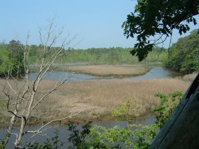
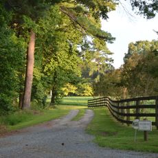
Bush Mill Stream Natural Area Preserve is a 144-acre protected area featuring fresh and brackish tidal wetlands where the stream meets the Great Wicomico River. The landscape combines open water, marsh vegetation, and wooded banks creating distinct habitats throughout the site.

Virginia's Department of Conservation and Recreation designated the site as a natural area preserve to protect critical wetland habitats and water resources in the Northern Neck region. This protected status ensured the preservation of these ecosystems for future generations.

The preserve functions as an educational site where visitors learn about tidal marsh ecosystems through interpretive trails and observation platforms.

The preserve opens daily from sunrise to sunset with the entrance accessed via VA 642, marked by a sign near the junction with VA 610. Visitors should follow marked routes through the wetlands to explore the site safely and respect the protected environment.

The preserve harbors Virginia's largest population of the rare bog fern Coryphopteris simulata within its protected swamp environments. This plant species is found nowhere else in such concentration in the surrounding region.

Location: Virginia

GPS coordinates: 37.87240,-76.44860

Latest update: December 14, 2025 13:07

Photos
Around this place
Point Lookout State Park
United States of America

Point Lookout State Park

23.6 km
Point Lookout Light
United States of America

Point Lookout Light

21.6 km
Belle Isle State Park
United States of America

Belle Isle State Park

17.2 km
Smith Point Light
United States of America

Smith Point Light

23.3 km
Point Lookout State Park
United States of America

Point Lookout State Park

23 km
Wheatland
United States of America

Wheatland

15.3 km
USS Aquamarine
United States of America

USS Aquamarine

23.3 km
Lancaster Court House Historic District
United States of America

Lancaster Court House Historic District

11.5 km
St. Stephen's Church
United States of America

St. Stephen's Church

5.7 km
Mary Ball Washington Museum and Library
United States of America

Mary Ball Washington Museum and Library

11.5 km
Great Wicomico River Light
United States of America

Great Wicomico River Light

17.6 km
Linden Farm
United States of America

Linden Farm

16.4 km
Reedville Historic District
United States of America

Reedville Historic District

15.5 km
Woodford
United States of America

Woodford

20.1 km
Coan Baptist Church
United States of America

Coan Baptist Church

8.2 km
Heathsville Historic District
United States of America

Heathsville Historic District

5.6 km
Village of Morattico Historic District
United States of America

Village of Morattico Historic District

18.4 km
Kinsale Historic District
United States of America

Kinsale Historic District

21 km
The Academy
United States of America

The Academy

6.3 km
Versailles
United States of America

Versailles

8.6 km
Kirkland Grove Campground
United States of America

Kirkland Grove Campground

4.5 km
Holley Graded School
United States of America

Holley Graded School

11.7 km
Bluff Point Graded School No. 3
United States of America

Bluff Point Graded School No. 3

20.5 km
Steuart Blakemore Building
United States of America

Steuart Blakemore Building

11.5 km
Elva C
United States of America

Elva C

15.5 km
Clifton
United States of America

Clifton

19 km
Claughton-Wright House
United States of America

Claughton-Wright House

14.7 km
Reedville Fishermen's Museum
United States of America

Reedville Fishermen's Museum

15.6 km
Show the full map
Reviews

Visited this place? Tap the stars to rate it and share your experience / photos with the community! Try now! You can cancel it anytime.

« Bush Mill Stream Natural Area Preserve - Protected wetland area in Northumberland County, Virginia, United States » is provided by Around Us (aroundus.com). Images and texts are derived from Wikimedia project under a Creative Commons license. You are allowed to copy, distribute, and modify copies of this page, under the conditions set by the license, as long as this note is clearly visible.

Discover hidden gems everywhere you go!

From secret cafés to breathtaking viewpoints, skip the crowded tourist spots and find places that match your style. Our app makes it easy with voice search, smart filtering, route optimization, and insider tips from travelers worldwide. Download now for the complete mobile experience.

Around Us App Screenshot

A unique approach to discovering new places

Le Figaro

All the places worth exploring

France Info

A tailor-made excursion in just a few clicks

20 Minutes