Enable Location

We need your location to show you interesting places around you

Discover nearby places

Find interesting locations and hidden gems around you

Precise directions

Get accurate directions and distances to places

Your location is never shared with other users. It's only used when you tap the location button.

Point Lookout Light

Log in to your account

Start exploring — it's free

Trusted by 63,116 travelers worldwide

Continue with Google
Continue with Apple
or

We will send you a code to connect

By continuing, you accept our Terms and Conditions and our Privacy Policy

Check your inbox

We've sent a pincode in your inbox. Please enter the code below.

Point Lookout Light
Discussion Reviews 1 Photos
5.5k Popularity

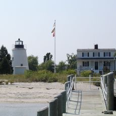
Point Lookout Light, Maritime navigation aid in St. Mary's County, Maryland

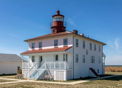
Point Lookout Light is a lighthouse standing about 41 feet tall at the entrance to the Potomac River, constructed with wooden framing and brick foundations supporting a roof-mounted lantern. The structure serves as a navigation aid for vessels passing through this strategic waterway.

The lighthouse began operating in 1830 under keeper James Davis and was later managed by his daughter Ann until 1847. This early period established maritime safety in the region and set standards for future navigation aids.

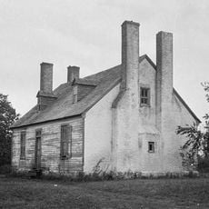
The lighthouse grounds became a significant military site during the Civil War, serving as a hospital and then a prison camp for soldiers. This period remains an important part of the site's identity and local memory.

The light beam can reach about 18 nautical miles across the water, helping vessels navigate safely into the Potomac River and Chesapeake Bay. Visitors should expect exposed conditions with wind and water at this promontory location.

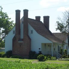
The structure received separate living quarters in 1927 designed as a duplex, allowing the keeper and assistant keeper to maintain independent homes. This feature reflects how lighthouse operations were modernized during the twentieth century.

The community of curious travelers

AroundUs brings together thousands of curated places, local tips, and hidden gems, enriched daily by 60,000 contributors worldwide.

Start exploring
Inception
1830
GPS coordinates
38.03870,-76.32210
Latest update
December 9, 2025 18:49
Around this place
Point Lookout State Park
United States of America

Point Lookout State Park

3.1 km
St. Ignatius Roman Catholic Church
United States of America

St. Ignatius Roman Catholic Church

15.3 km
Holland Island Bar Light
United States of America

Holland Island Bar Light

20.1 km
Spence's Point
United States of America

Spence's Point

21.1 km
Smith Point Light
United States of America

Smith Point Light

21.5 km
Point No Point Light
United States of America

Point No Point Light

10.3 km
Porto Bello
United States of America

Porto Bello

18.9 km
Point Lookout State Park
United States of America

Point Lookout State Park

2.6 km
West St. Mary's Manor
United States of America

West St. Mary's Manor

19.8 km
Piney Point Light
United States of America

Piney Point Light

21.1 km
Bush Mill Stream Natural Area Preserve
United States of America

Bush Mill Stream Natural Area Preserve

21.6 km
Wheatland
United States of America

Wheatland

17.3 km
St. Stephen's Church
United States of America

St. Stephen's Church

18.8 km
Cross Manor
United States of America

Cross Manor

16.2 km
Reedville Historic District
United States of America

Reedville Historic District

22.3 km
Coan Baptist Church
United States of America

Coan Baptist Church

21.1 km
Heathsville Historic District
United States of America

Heathsville Historic District

18.8 km
Bard's Field
United States of America

Bard's Field

8.5 km
The Academy
United States of America

The Academy

19 km
Versailles
United States of America

Versailles

17.1 km
James P. Muldoon River Center
United States of America

James P. Muldoon River Center

19.3 km
Kirkland Grove Campground
United States of America

Kirkland Grove Campground

21 km
Holley Graded School
United States of America

Holley Graded School

19.3 km
Elva C
United States of America

Elva C

22.1 km
Historic St. Mary's City
United States of America

Historic St. Mary's City

18.4 km
Claughton-Wright House
United States of America

Claughton-Wright House

17.5 km
Piney Point Lighthouse Museum & Historic Park
United States of America

Piney Point Lighthouse Museum & Historic Park

21.2 km
Reedville Fishermen's Museum
United States of America

Reedville Fishermen's Museum

22.1 km
Show the full map
Reviews
Share your experience

No review yet

Discussions
Start a discussion...

No discussion yet

« Point Lookout Light - Maritime navigation aid in St. Mary's County, Maryland » is provided by Around Us (aroundus.com). Images and texts are derived from Wikimedia project under a Creative Commons license. You are allowed to copy, distribute, and modify copies of this page, under the conditions set by the license, as long as this note is clearly visible.

Discover hidden gems everywhere you go!

From secret cafés to breathtaking viewpoints, skip the crowded tourist spots and find places that match your style. Our app makes it easy with voice search, smart filtering, route optimization, and insider tips from travelers worldwide. Download now for the complete mobile experience.

Around Us App Screenshot

A unique approach to discovering new places

Le Figaro

All the places worth exploring

France Info

A tailor-made excursion in just a few clicks

20 Minutes

Around Us
Travel Guide & Maps
Download

Send to your phone

QR Code
1

Open the camera app on your mobile.

2

Point at the QR code with your camera. A notification will appear.

3

Tap the notification to open the link.