Enable Location

We need your location to show you interesting places around you

Discover nearby places

Find interesting locations and hidden gems around you

Precise directions

Get accurate directions and distances to places

Your location is never shared with other users. It's only used when you tap the location button.

Great Wicomico River Light

Log in to your account

Start exploring — it's free

Trusted by 63,118 travelers worldwide

Continue with Google
Continue with Apple
or

We will send you a code to connect

By continuing, you accept our Terms and Conditions and our Privacy Policy

Check your inbox

We've sent a pincode in your inbox. Please enter the code below.

Great Wicomico River Light
Discussion Reviews 1 Photos
1.3k Popularity

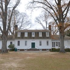
Great Wicomico River Light, Maritime beacon at Great Wicomico River mouth, Virginia, US.

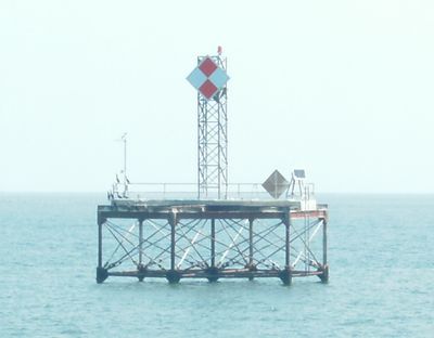
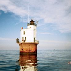
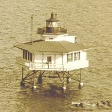
Great Wicomico River Light is a lighthouse positioned at the mouth of the Great Wicomico River in Virginia, standing on a screwpile foundation in the western Chesapeake Bay. The hexagonal tower rises from the water and was designed to guide vessels navigating through this important shipping channel.

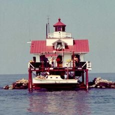
The lighthouse was built in 1889 and served as a navigation aid for vessels on Chesapeake Bay until 1967. After its deactivation, the original wooden and iron structure was replaced with a modern beacon while the historic screwpile foundation remained in place.

The lighthouse reflects the maritime development of Virginia's coastal region, serving as a testament to 19th-century navigational infrastructure.

The location sits in the shallow waters of Chesapeake Bay and is best viewed from the water or through boat tours in the area. The lighthouse itself is not open to the public for visits, but can be photographed by those taking river cruises or coastal exploration tours.

The lighthouse was built on a screwpile foundation, an innovative engineering technique that allowed structures to be anchored in shallow coastal waters. This method made it possible to construct lighthouses in locations where conventional foundations would have been impossible.

The community of curious travelers

AroundUs brings together thousands of curated places, local tips, and hidden gems, enriched daily by 60,000 contributors worldwide.

Start exploring
GPS coordinates
37.80420,-76.26750
Latest update
December 14, 2025 17:40
Around this place
Corotoman
United States of America

Corotoman

22.8 km
Robert O. Norris Bridge
United States of America

Robert O. Norris Bridge

24.3 km
Point Lookout Light
United States of America

Point Lookout Light

26.5 km
Belle Isle State Park
United States of America

Belle Isle State Park

29.4 km
Smith Point Light
United States of America

Smith Point Light

11.2 km
Point Lookout State Park
United States of America

Point Lookout State Park

29 km
Stingray Point Light
United States of America

Stingray Point Light

27 km
Bush Mill Stream Natural Area Preserve
United States of America

Bush Mill Stream Natural Area Preserve

17.6 km
USS Aquamarine
United States of America

USS Aquamarine

21.4 km
Lancaster Court House Historic District
United States of America

Lancaster Court House Historic District

17.8 km
St. Stephen's Church
United States of America

St. Stephen's Church

22.2 km
Mary Ball Washington Museum and Library
United States of America

Mary Ball Washington Museum and Library

17.8 km
Tangier Sound Light
United States of America

Tangier Sound Light

25.9 km
F.D. Crockett
United States of America

F.D. Crockett

28.5 km
Reedville Historic District
United States of America

Reedville Historic District

4.3 km
Coan Baptist Church
United States of America

Coan Baptist Church

25.5 km
Heathsville Historic District
United States of America

Heathsville Historic District

22.1 km
The Academy
United States of America

The Academy

23 km
Versailles
United States of America

Versailles

11.9 km
Kirkland Grove Campground
United States of America

Kirkland Grove Campground

22 km
Holley Graded School
United States of America

Holley Graded School

28.2 km
Bluff Point Graded School No. 3
United States of America

Bluff Point Graded School No. 3

12.1 km
Steuart Blakemore Building
United States of America

Steuart Blakemore Building

17.8 km
Elva C
United States of America

Elva C

4.5 km
Clifton
United States of America

Clifton

13.6 km
Deltaville Maritime Museum
United States of America

Deltaville Maritime Museum

28.6 km
Tangier History Museum
United States of America

Tangier History Museum

24.4 km
Reedville Fishermen's Museum
United States of America

Reedville Fishermen's Museum

4.4 km
Show the full map
Reviews
Share your experience

No review yet

Discussions
Start a discussion...

No discussion yet

« Great Wicomico River Light - Maritime beacon at Great Wicomico River mouth, Virginia, US » is provided by Around Us (aroundus.com). Images and texts are derived from Wikimedia project under a Creative Commons license. You are allowed to copy, distribute, and modify copies of this page, under the conditions set by the license, as long as this note is clearly visible.

Discover hidden gems everywhere you go!

From secret cafés to breathtaking viewpoints, skip the crowded tourist spots and find places that match your style. Our app makes it easy with voice search, smart filtering, route optimization, and insider tips from travelers worldwide. Download now for the complete mobile experience.

Around Us App Screenshot

A unique approach to discovering new places

Le Figaro

All the places worth exploring

France Info

A tailor-made excursion in just a few clicks

20 Minutes

Around Us
Travel Guide & Maps
Download

Send to your phone

QR Code
1

Open the camera app on your mobile.

2

Point at the QR code with your camera. A notification will appear.

3

Tap the notification to open the link.