Enable Location

We need your location to show you interesting places around you

Discover nearby places

Find interesting locations and hidden gems around you

Precise directions

Get accurate directions and distances to places

Your location is never shared with other users. It's only used when you tap the location button.

Stingray Point Light

Log in to your account

Start exploring — it's free

Trusted by 61,763 travelers worldwide

Continue with Google
Continue with Apple
or

We will send you a code to connect

By continuing, you accept our Terms and Conditions and our Privacy Policy

Check your inbox

We've sent a pincode in your inbox. Please enter the code below.

Stingray Point Light

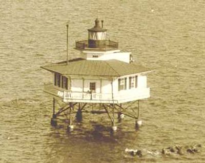
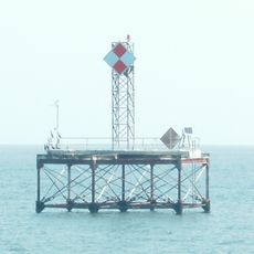
Stingray Point Light, Maritime navigation point at Rappahannock River mouth, Middlesex County, US.

Description

Stingray Point Light was a hexagonal wooden lighthouse supported by screwpiles, standing roughly 34 feet (10 meters) tall with a central lantern room. The lantern housed a sixth-order Fresnel lens that projected light to guide passing vessels.

History

Congress approved funding in 1853 for lighthouse construction after numerous vessels ran aground near the Rappahannock River entrance. The structure operated from 1858 until 1965, serving as a critical navigation aid in the region.

Culture

The lighthouse takes its name from a 1608 incident when explorer John Smith was injured by a stingray while fishing in these waters. This historical origin connects the site to early colonial exploration of the region.

Practical

The lighthouse projected a fixed red light visible from about 7 nautical miles away, helping boat captains navigate safely through the channel. Since it stands in water, visiting it requires access by boat from nearby launch points.

Did you know?

During storms, the lighthouse would sway noticeably on its foundation, a condition that keeper Levi Marchant had to manage during his long tenure from 1889 to 1921. This constant motion made the structure both an engineering marvel and a test of the keeper's nerve.

Location
Inception
1858
GPS coordinates
37.56130,-76.27000
Latest update
December 14, 2025 12:24

AroundUs brings together thousands of curated places, local tips, and hidden gems, enriched daily by 60,000 contributors worldwide. Discover all places nearby (Middlesex County).

Around this place
Corotoman
United States of America

Corotoman

18.5 km
Wolf Trap Light
United States of America

Wolf Trap Light

20.3 km
Robert O. Norris Bridge
United States of America

Robert O. Norris Bridge

15.2 km
Bethel Beach Natural Area Preserve
United States of America

Bethel Beach Natural Area Preserve

17 km
Toddsbury
United States of America

Toddsbury

21.3 km
Zion Poplars Baptist Church
United States of America

Zion Poplars Baptist Church

27.6 km
Lower Church
United States of America

Lower Church

16.8 km
USS Aquamarine
United States of America

USS Aquamarine

18.4 km
Burgh Westra
United States of America

Burgh Westra

22.6 km
T.C. Walker House
United States of America

T.C. Walker House

27.7 km
Great Wicomico River Light
United States of America

Great Wicomico River Light

27 km
Lowland Cottage
United States of America

Lowland Cottage

25 km
F.D. Crockett
United States of America

F.D. Crockett

5.1 km
Poplar Grove Mill and House
United States of America

Poplar Grove Mill and House

18.9 km
Sibley's and James Store Historic District
United States of America

Sibley's and James Store Historic District

14.7 km
Gloucester Downtown Historic District
United States of America

Gloucester Downtown Historic District

27.8 km
Sandwich
United States of America

Sandwich

28 km
Billups House
United States of America

Billups House

13.5 km
Urbanna Historic District
United States of America

Urbanna Historic District

28.1 km
Mathews County Courthouse Square
United States of America

Mathews County Courthouse Square

15 km
Gloucester Women's Club
United States of America

Gloucester Women's Club

27.6 km
Springdale
United States of America

Springdale

16.3 km
Fort Cricket Hill
United States of America

Fort Cricket Hill

8.8 km
Riverlawn
United States of America

Riverlawn

18 km
Bluff Point Graded School No. 3
United States of America

Bluff Point Graded School No. 3

17.6 km
Clifton
United States of America

Clifton

19.1 km
Mathews Downtown Historic District
United States of America

Mathews Downtown Historic District

15 km
Deltaville Maritime Museum
United States of America

Deltaville Maritime Museum

5 km
Show the full map
« Stingray Point Light - Maritime navigation point at Rappahannock River mouth, Middlesex County, US » is provided by Around Us (aroundus.com). Images and texts are derived from Wikimedia project under a Creative Commons license. You are allowed to copy, distribute, and modify copies of this page, under the conditions set by the license, as long as this note is clearly visible.

Discover hidden gems everywhere you go!

From secret cafés to breathtaking viewpoints, skip the crowded tourist spots and find places that match your style. Our app makes it easy with voice search, smart filtering, route optimization, and insider tips from travelers worldwide. Download now for the complete mobile experience.

Around Us App Screenshot

A unique approach to discovering new places

Le Figaro

All the places worth exploring

France Info

A tailor-made excursion in just a few clicks

20 Minutes

Around Us
Travel Guide & Maps
Download

Send to your phone

QR Code
1

Open the camera app on your mobile.

2

Point at the QR code with your camera. A notification will appear.

3

Tap the notification to open the link.