·

Enable Location

We need your location to show you interesting places around you

Discover nearby places

Find interesting locations and hidden gems around you

Precise directions

Get accurate directions and distances to places

Your location is never shared with other users. It's only used when you tap the location button.

Wolf Trap Light

Log in to your account

Start exploring — it's free

Trusted by 62,750 travelers worldwide

Continue with Google
Continue with Apple
or

We will send you a code to connect

By continuing, you accept our Terms and Conditions and our Privacy Policy

Check your inbox

We've sent a pincode in your inbox. Please enter the code below.

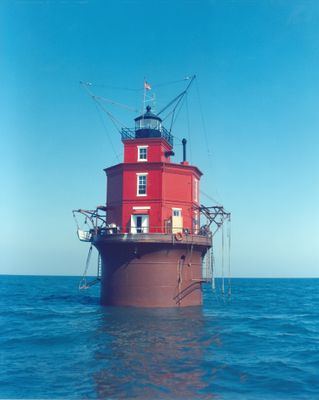
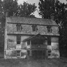
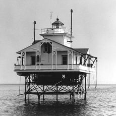
Wolf Trap Light, Maritime lighthouse in Mathews County, US.

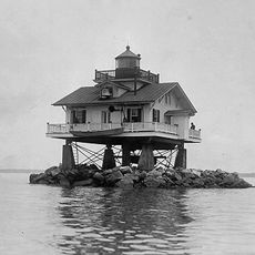
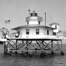
Wolf Trap Light is an octagonal two-story brick structure with a square tower and cast-iron lantern that rises 52 feet above Chesapeake Bay waters. The building stands on a rare pneumatic caisson foundation, engineered to guide vessels safely through these waters.

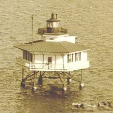
The current lighthouse replaced a screw-pile structure destroyed by ice in 1893, after the original lightship had been lost during the Civil War. This succession of replacements shows how natural forces and warfare shaped navigation aids in the bay.

The name comes from HMS Wolf, a British warship that ran aground in 1691 while enforcing trade laws and fighting pirates in the bay. This naming connects the location to an episode from the region's early maritime conflicts.

The automated light system sends a white flash every 15 seconds to guide vessels in the area. Access to this waterfront location requires travel across the bay, so plan accordingly to view the structure.

This lighthouse stands on a pneumatic caisson foundation, an extremely rare construction method used in only eleven lighthouses across the United States. This specialized technique represents an early engineering innovation in coastal construction.

The community of curious travelers

AroundUs brings together thousands of curated places, local tips, and hidden gems, enriched daily by 60,000 contributors worldwide.

Start exploring
Location
Inception
1821
GPS coordinates
37.39000,-76.19000
Latest update
December 9, 2025 18:46
Around this place
Custis Tombs
United States of America

Custis Tombs

24.4 km
Eyre Hall
United States of America

Eyre Hall

21 km
New Point Comfort Light
United States of America

New Point Comfort Light

12.6 km
Savage Neck Dunes Natural Area Preserve
United States of America

Savage Neck Dunes Natural Area Preserve

17.3 km
Bethel Beach Natural Area Preserve
United States of America

Bethel Beach Natural Area Preserve

5.9 km
Toddsbury
United States of America

Toddsbury

23.6 km
Stingray Point Light
United States of America

Stingray Point Light

20.3 km
Old Plantation Flats Light
United States of America

Old Plantation Flats Light

22 km
Cape Charles Historic District
United States of America

Cape Charles Historic District

20.4 km
Burgh Westra
United States of America

Burgh Westra

23.6 km
York Spit Light
United States of America

York Spit Light

20.9 km
Vaucluse
United States of America

Vaucluse

19.2 km
Pear Valley
United States of America

Pear Valley

23.5 km
Lands End
United States of America

Lands End

22.1 km
F.D. Crockett
United States of America

F.D. Crockett

21.8 km
Poplar Grove Mill and House
United States of America

Poplar Grove Mill and House

12.6 km
Tue Marshes Light
United States of America

Tue Marshes Light

24.4 km
Cherrystone Bar Light
United States of America

Cherrystone Bar Light

20.4 km
Sibley's and James Store Historic District
United States of America

Sibley's and James Store Historic District

12.6 km
Northampton County Courthouse Historical District
United States of America

Northampton County Courthouse Historical District

21.9 km
Winona
United States of America

Winona

23.5 km
Billups House
United States of America

Billups House

10.3 km
Eastville Historical District
United States of America

Eastville Historical District

22 km
Mathews County Courthouse Square
United States of America

Mathews County Courthouse Square

12.7 km
Springdale
United States of America

Springdale

12.7 km
Fort Cricket Hill
United States of America

Fort Cricket Hill

14.9 km
Riverlawn
United States of America

Riverlawn

13.6 km
Mathews Downtown Historic District
United States of America

Mathews Downtown Historic District

12.7 km
Show the full map
« Wolf Trap Light - Maritime lighthouse in Mathews County, US » is provided by Around Us (aroundus.com). Images and texts are derived from Wikimedia project under a Creative Commons license. You are allowed to copy, distribute, and modify copies of this page, under the conditions set by the license, as long as this note is clearly visible.

Discover hidden gems everywhere you go!

From secret cafés to breathtaking viewpoints, skip the crowded tourist spots and find places that match your style. Our app makes it easy with voice search, smart filtering, route optimization, and insider tips from travelers worldwide. Download now for the complete mobile experience.

Around Us App Screenshot

A unique approach to discovering new places

Le Figaro

All the places worth exploring

France Info

A tailor-made excursion in just a few clicks

20 Minutes

Around Us
Travel Guide & Maps
Download

Send to your phone

QR Code
1

Open the camera app on your mobile.

2

Point at the QR code with your camera. A notification will appear.

3

Tap the notification to open the link.