Enable Location

We need your location to show you interesting places around you

Discover nearby places

Find interesting locations and hidden gems around you

Precise directions

Get accurate directions and distances to places

Your location is never shared with other users. It's only used when you tap the location button.

Cherrystone Bar Light

Log in to your account

Start exploring — it's free

Trusted by 62,417 travelers worldwide

Continue with Google
Continue with Apple
or

We will send you a code to connect

By continuing, you accept our Terms and Conditions and our Privacy Policy

Check your inbox

We've sent a pincode in your inbox. Please enter the code below.

Cherrystone Bar Light

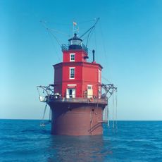
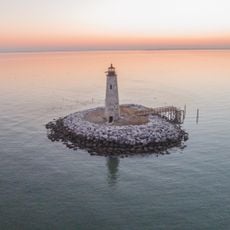
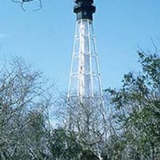
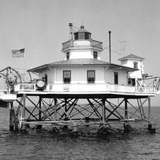
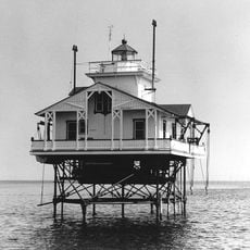
Cherrystone Bar Light, lighthouse in Virginia, United States

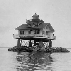
Cherrystone Bar Light is a lighthouse at the entrance to Cherrystone Harbor in Virginia, built on a sandbar using a screw-pile foundation. The hexagonal structure used a fourth-order Fresnel lens to guide ships safely through shallow waters during day and night and in poor weather.

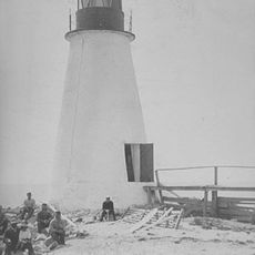
The lighthouse was built in 1853 and lit in 1859 to guide ships through dangerous waters around Cherrystone Harbor. During the Civil War it was extinguished by Confederate forces, but Union troops restored it in 1862 and it continued serving for decades.

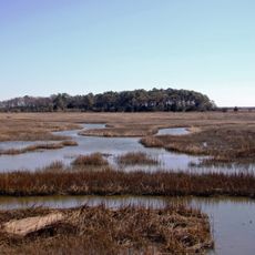
The lighthouse served as a vital navigation marker for sailors and captains navigating the shallow waters of Chesapeake Bay. Its simple design and reliable function made it a recognizable feature for all those who traveled this route.

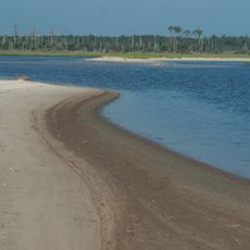
The lighthouse is located southwest of Cape Charles on the Virginia coast and is easy to find on maps. The site is surrounded by water, so visitors can best view and explore it from a boat or nearby shore points.

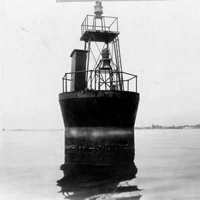
The original building was removed in 1919 and loaded onto a barge for replacement, but it was preserved well enough to be transported elsewhere. The structure was relocated to the Choptank River in Maryland in 1921, where it continued guiding ships, making it the only case where a lighthouse was moved to a different location to continue serving.

The community of curious travelers

AroundUs brings together thousands of curated places, local tips, and hidden gems, enriched daily by 60,000 contributors worldwide.

Start exploring
GPS coordinates
37.25640,-76.03240
Latest update
February 9, 2026 07:42
Around this place
Chesapeake Bay Bridge-Tunnel
United States of America

Chesapeake Bay Bridge-Tunnel

25.6 km
Kiptopeke State Park
United States of America

Kiptopeke State Park

10.8 km
Wolf Trap Light
United States of America

Wolf Trap Light

20.4 km
Custis Tombs
United States of America

Custis Tombs

4 km
Eyre Hall
United States of America

Eyre Hall

7.8 km
Plum Tree Island National Wildlife Refuge
United States of America

Plum Tree Island National Wildlife Refuge

29.2 km
New Point Comfort Light
United States of America

New Point Comfort Light

22.3 km
Cape Charles Light
United States of America

Cape Charles Light

18.6 km
Eastern Shore of Virginia National Wildlife Refuge
United States of America

Eastern Shore of Virginia National Wildlife Refuge

15.6 km
Coast Guard Station Cobb Island
United States of America

Coast Guard Station Cobb Island

10.5 km
Savage Neck Dunes Natural Area Preserve
United States of America

Savage Neck Dunes Natural Area Preserve

8 km
Bethel Beach Natural Area Preserve
United States of America

Bethel Beach Natural Area Preserve

25.8 km
Back River Light
United States of America

Back River Light

28.3 km
Almshouse Farm at Machipongo
United States of America

Almshouse Farm at Machipongo

19.9 km
Old Plantation Flats Light
United States of America

Old Plantation Flats Light

3.3 km
Cape Charles Historic District
United States of America

Cape Charles Historic District

2.1 km
York Spit Light
United States of America

York Spit Light

20.3 km
Vaucluse
United States of America

Vaucluse

19.7 km
Pear Valley
United States of America

Pear Valley

18.3 km
Poplar Grove Mill and House
United States of America

Poplar Grove Mill and House

30.9 km
Tue Marshes Light
United States of America

Tue Marshes Light

31.4 km
Northampton County Courthouse Historical District
United States of America

Northampton County Courthouse Historical District

13.1 km
Brownsville
United States of America

Brownsville

29.8 km
Winona
United States of America

Winona

22.7 km
Billups House
United States of America

Billups House

30.5 km
Eastville Historical District
United States of America

Eastville Historical District

13.2 km
Northampton Lumber Company Historic District
United States of America

Northampton Lumber Company Historic District

28.6 km
Fisherman Island National Wildlife Refuge
United States of America

Fisherman Island National Wildlife Refuge

19.1 km
Show the full map
« Cherrystone Bar Light - lighthouse in Virginia, United States » is provided by Around Us (aroundus.com). Images and texts are derived from Wikimedia project under a Creative Commons license. You are allowed to copy, distribute, and modify copies of this page, under the conditions set by the license, as long as this note is clearly visible.

Discover hidden gems everywhere you go!

From secret cafés to breathtaking viewpoints, skip the crowded tourist spots and find places that match your style. Our app makes it easy with voice search, smart filtering, route optimization, and insider tips from travelers worldwide. Download now for the complete mobile experience.

Around Us App Screenshot

A unique approach to discovering new places

Le Figaro

All the places worth exploring

France Info

A tailor-made excursion in just a few clicks

20 Minutes

Around Us
Travel Guide & Maps
Download

Send to your phone

QR Code
1

Open the camera app on your mobile.

2

Point at the QR code with your camera. A notification will appear.

3

Tap the notification to open the link.