·

Enable Location

We need your location to show you interesting places around you

Discover nearby places

Find interesting locations and hidden gems around you

Precise directions

Get accurate directions and distances to places

Your location is never shared with other users. It's only used when you tap the location button.

Back River Light

Log in to your account

Start exploring — it's free

Trusted by 62,739 travelers worldwide

Continue with Google
Continue with Apple
or

We will send you a code to connect

By continuing, you accept our Terms and Conditions and our Privacy Policy

Check your inbox

We've sent a pincode in your inbox. Please enter the code below.

Back River Light

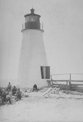
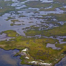
Back River Light, Historic lighthouse on Chesapeake Bay in Hampton, United States

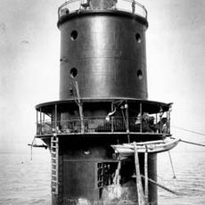
Back River Light was a conical brick tower standing on the western shore of Chesapeake Bay that rose approximately 30 feet high. The structure housed ten oil lamps fitted with large reflectors that projected light across the water to guide passing vessels.

The light was constructed in 1829 by Winslow Lewis of Boston and operated for over a century guiding ships through the waterway. Environmental pressures forced its closure in 1936, and the deteriorating structure collapsed in 1956.

The lighthouse served as a familiar landmark for fishermen and mariners navigating the bay for over a century. The structure became woven into the rhythm of local maritime life and represented the region's connection to the water.

The site faced constant erosion from the bay, requiring multiple protective installations over the decades to stabilize the shoreline. Since the original structure no longer stands, visitors interested in its history will need to seek out nearby historical markers or resources to learn about this former landmark.

A wooden footbridge stretching approximately 144 feet connected the keeper's living quarters directly to the tower across the surrounding marsh. This walkway allowed the keeper to reach the light daily without having to wade through water.

The community of curious travelers

AroundUs brings together thousands of curated places, local tips, and hidden gems, enriched daily by 60,000 contributors worldwide.

Start exploring
Location
GPS coordinates
37.08720,-76.26980
Latest update
December 14, 2025 12:27
Around this place
Fort Monroe
United States of America

Fort Monroe

9.9 km
Langley Research Center
United States of America

Langley Research Center

10 km
Emancipation Oak
United States of America

Emancipation Oak

8.9 km
Thimble Shoal Light
United States of America

Thimble Shoal Light

8.5 km
Air Power Park
United States of America

Air Power Park

9.9 km
Hampton National Cemetery
United States of America

Hampton National Cemetery

9.2 km
Armstrong Stadium
United States of America

Armstrong Stadium

9.3 km
Plum Tree Island National Wildlife Refuge
United States of America

Plum Tree Island National Wildlife Refuge

7.8 km
Variable Density Tunnel
United States of America

Variable Density Tunnel

6.7 km
Langley Full-Scale Tunnel
United States of America

Langley Full-Scale Tunnel

6.4 km
Virginia Air and Space Science Center
United States of America

Virginia Air and Space Science Center

9.7 km
Rendezvous Docking Simulator
United States of America

Rendezvous Docking Simulator

9.6 km
Hampton Downtown Historic District
United States of America

Hampton Downtown Historic District

9.5 km
Chapel of the Centurion
United States of America

Chapel of the Centurion

10 km
Herbert House
United States of America

Herbert House

10.3 km
Buckroe Beach Carousel
United States of America

Buckroe Beach Carousel

9.6 km
Quarters 1
United States of America

Quarters 1

9.8 km
Eight-Foot High Speed Tunnel
United States of America

Eight-Foot High Speed Tunnel

6.4 km
Quarters 17
United States of America

Quarters 17

10 km
Hampton City Hall
United States of America

Hampton City Hall

9.5 km
Reuben Clark House
United States of America

Reuben Clark House

9.2 km
Hampton National Guard Armory
United States of America

Hampton National Guard Armory

9.1 km
Pasture Point Historic District
United States of America

Pasture Point Historic District

8.8 km
Scott House
United States of America

Scott House

10.1 km
William H. Trusty House
United States of America

William H. Trusty House

8.8 km
Old Point Comfort Light
United States of America

Old Point Comfort Light

10.1 km
American Theater
United States of America

American Theater

9 km
Salt Ponds Beach
United States of America

Salt Ponds Beach

3.3 km
Show the full map
« Back River Light - Historic lighthouse on Chesapeake Bay in Hampton, United States » is provided by Around Us (aroundus.com). Images and texts are derived from Wikimedia project under a Creative Commons license. You are allowed to copy, distribute, and modify copies of this page, under the conditions set by the license, as long as this note is clearly visible.

Discover hidden gems everywhere you go!

From secret cafés to breathtaking viewpoints, skip the crowded tourist spots and find places that match your style. Our app makes it easy with voice search, smart filtering, route optimization, and insider tips from travelers worldwide. Download now for the complete mobile experience.

Around Us App Screenshot

A unique approach to discovering new places

Le Figaro

All the places worth exploring

France Info

A tailor-made excursion in just a few clicks

20 Minutes

Around Us
Travel Guide & Maps
Download

Send to your phone

QR Code
1

Open the camera app on your mobile.

2

Point at the QR code with your camera. A notification will appear.

3

Tap the notification to open the link.