Enable Location

We need your location to show you interesting places around you

Discover nearby places

Find interesting locations and hidden gems around you

Precise directions

Get accurate directions and distances to places

Your location is never shared with other users. It's only used when you tap the location button.

Variable Density Tunnel

Log in to your account

Start exploring — it's free

Trusted by 63,103 travelers worldwide

Continue with Google
Continue with Apple
or

We will send you a code to connect

By continuing, you accept our Terms and Conditions and our Privacy Policy

Check your inbox

We've sent a pincode in your inbox. Please enter the code below.

Discussion Reviews 1 Photos
2.9k Popularity

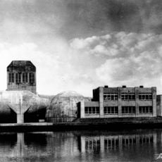
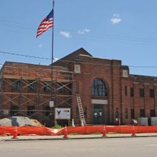
Variable Density Tunnel, National Historic Landmark wind tunnel in Hampton, Virginia, US

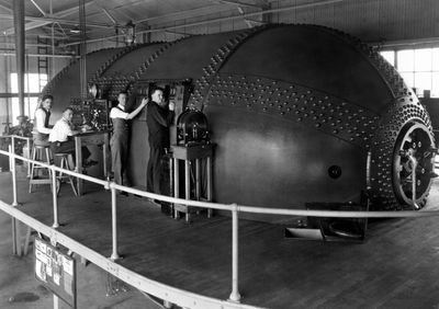
The Variable Density Tunnel is a wind tunnel at NASA Langley Research Center designed specifically for testing aircraft models. The steel tank measures approximately 34 feet long and 15 feet in diameter, housing all the equipment needed for aerodynamic research.

It was built in 1921 and introduced pressurized testing to American aeronautical research. This innovation allowed engineers to study aircraft designs under a range of conditions, leading to significant advances in flight technology.

The facility shaped how engineers thought about aircraft design during aviation's formative years. Visitors can sense this historical importance by seeing where groundbreaking aerodynamic work took place.

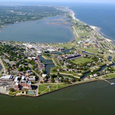
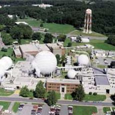
The tunnel is located on the NASA Langley Research Center grounds and can be viewed by visitors. It is worth checking ahead about access times and any security requirements, as it remains part of an active research facility.

The steel tank operated under extreme pressure conditions to create realistic testing scenarios for aircraft models. These high pressures allowed researchers to gather data that more accurately predicted how real aircraft would perform in flight.

The community of curious travelers

AroundUs brings together thousands of curated places, local tips, and hidden gems, enriched daily by 60,000 contributors worldwide.

Start exploring
Location
Inception
1921
Architects
Michael Max Munk
GPS coordinates
37.07860,-76.34420
Latest update
December 12, 2025 12:08
Around this place
Fort Monroe
United States of America

Fort Monroe

9 km
Langley Research Center
United States of America

Langley Research Center

3.7 km
Hampton Coliseum
United States of America

Hampton Coliseum

5.9 km
Emancipation Oak
United States of America

Emancipation Oak

6.3 km
Air Power Park
United States of America

Air Power Park

4.4 km
Hampton National Cemetery
United States of America

Hampton National Cemetery

6.7 km
Armstrong Stadium
United States of America

Armstrong Stadium

6.5 km
Plum Tree Island National Wildlife Refuge
United States of America

Plum Tree Island National Wildlife Refuge

7 km
Landing and Impact Research Facility
United States of America

Landing and Impact Research Facility

4.8 km
Cinema Cafe
United States of America

Cinema Cafe

5.2 km
Langley Full-Scale Tunnel
United States of America

Langley Full-Scale Tunnel

331 m
Virginia Air and Space Science Center
United States of America

Virginia Air and Space Science Center

6.1 km
Rendezvous Docking Simulator
United States of America

Rendezvous Docking Simulator

3.1 km
Hampton Downtown Historic District
United States of America

Hampton Downtown Historic District

5.8 km
Back River Light
United States of America

Back River Light

6.7 km
Victoria Boulevard Historic District
United States of America

Victoria Boulevard Historic District

6.6 km
Herbert House
United States of America

Herbert House

7 km
Buckroe Beach Carousel
United States of America

Buckroe Beach Carousel

6.1 km
Old Wythe Historic District
United States of America

Old Wythe Historic District

8.9 km
Eight-Foot High Speed Tunnel
United States of America

Eight-Foot High Speed Tunnel

312 m
Hampton City Hall
United States of America

Hampton City Hall

5.8 km
Reuben Clark House
United States of America

Reuben Clark House

7.5 km
Hampton National Guard Armory
United States of America

Hampton National Guard Armory

5.3 km
Pasture Point Historic District
United States of America

Pasture Point Historic District

5.2 km
Scott House
United States of America

Scott House

6.2 km
William H. Trusty House
United States of America

William H. Trusty House

6.6 km
American Theater
United States of America

American Theater

7.2 km
Salt Ponds Beach
United States of America

Salt Ponds Beach

5.9 km
Show the full map
Reviews
Share your experience

No review yet

Discussions
Start a discussion...

No discussion yet

« Variable Density Tunnel - National Historic Landmark wind tunnel in Hampton, Virginia, US » is provided by Around Us (aroundus.com). Images and texts are derived from Wikimedia project under a Creative Commons license. You are allowed to copy, distribute, and modify copies of this page, under the conditions set by the license, as long as this note is clearly visible.

Discover hidden gems everywhere you go!

From secret cafés to breathtaking viewpoints, skip the crowded tourist spots and find places that match your style. Our app makes it easy with voice search, smart filtering, route optimization, and insider tips from travelers worldwide. Download now for the complete mobile experience.

Around Us App Screenshot

A unique approach to discovering new places

Le Figaro

All the places worth exploring

France Info

A tailor-made excursion in just a few clicks

20 Minutes

Around Us
Travel Guide & Maps
Download

Send to your phone

QR Code
1

Open the camera app on your mobile.

2

Point at the QR code with your camera. A notification will appear.

3

Tap the notification to open the link.