·

Enable Location

We need your location to show you interesting places around you

Discover nearby places

Find interesting locations and hidden gems around you

Precise directions

Get accurate directions and distances to places

Your location is never shared with other users. It's only used when you tap the location button.

York Spit Light

Log in to your account

Start exploring — it's free

Trusted by 62,746 travelers worldwide

Continue with Google
Continue with Apple
or

We will send you a code to connect

By continuing, you accept our Terms and Conditions and our Privacy Policy

Check your inbox

We've sent a pincode in your inbox. Please enter the code below.

York Spit Light

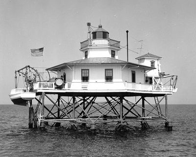
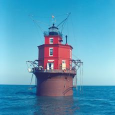
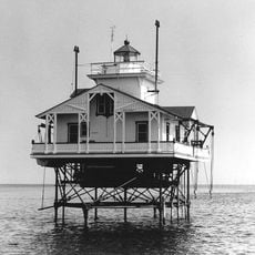
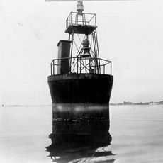
York Spit Light, Navigation lighthouse in Gloucester County, United States.

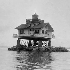
York Spit Light is a lighthouse standing at the entrance of York River in Chesapeake Bay, built with a hexagonal tower mounted on iron-reinforced wooden pilings. The design allows it to withstand the constant water movement and shifting sand formations that characterize this busy shipping corridor.

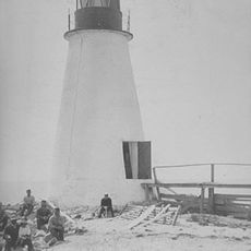
The lighthouse was built in 1870 to replace multiple lightships that had previously marked this waterway. Automation arrived in 1960, ending the era of lighthouse keepers stationed at the tower.

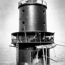
The lighthouse keepers maintained maritime safety records and performed rescue operations, including a notable 1916 rescue of nine people from a disabled launch.

The lighthouse can be viewed from the water but is not directly accessible to visitors. Your best vantage point is from a boat traveling through this waterway or from nearby observation points along the shore.

During construction, the builders needed 243 hammer blows per pile to achieve proper stability in the challenging underwater ground. This laborious hand-driven process reveals the extraordinary effort required to anchor a structure in this location.

The community of curious travelers

AroundUs brings together thousands of curated places, local tips, and hidden gems, enriched daily by 60,000 contributors worldwide.

Start exploring
GPS coordinates
37.20960,-76.25420
Latest update
December 14, 2025 16:43
Around this place
Langley Research Center
United States of America

Langley Research Center

17.3 km
Emancipation Oak
United States of America

Emancipation Oak

21.8 km
Langley Speedway
United States of America

Langley Speedway

18.1 km
Moore House
United States of America

Moore House

20.6 km
Wolf Trap Light
United States of America

Wolf Trap Light

20.9 km
Thimble Shoal Light
United States of America

Thimble Shoal Light

21.7 km
Air Power Park
United States of America

Air Power Park

21 km
Plum Tree Island National Wildlife Refuge
United States of America

Plum Tree Island National Wildlife Refuge

10.1 km
New Point Comfort Light
United States of America

New Point Comfort Light

10.4 km
Landing and Impact Research Facility
United States of America

Landing and Impact Research Facility

17 km
Cinema Cafe
United States of America

Cinema Cafe

21.7 km
Variable Density Tunnel
United States of America

Variable Density Tunnel

16.6 km
Langley Full-Scale Tunnel
United States of America

Langley Full-Scale Tunnel

16.3 km
Little England
United States of America

Little England

20.2 km
Rendezvous Docking Simulator
United States of America

Rendezvous Docking Simulator

17.6 km
Hampton Downtown Historic District
United States of America

Hampton Downtown Historic District

21.9 km
Back River Light
United States of America

Back River Light

13.7 km
Old Plantation Flats Light
United States of America

Old Plantation Flats Light

18.5 km
Cape Charles Historic District
United States of America

Cape Charles Historic District

22.1 km
Eight-Foot High Speed Tunnel
United States of America

Eight-Foot High Speed Tunnel

16.3 km
Lands End
United States of America

Lands End

20 km
Poplar Grove Mill and House
United States of America

Poplar Grove Mill and House

22.1 km
Tue Marshes Light
United States of America

Tue Marshes Light

12 km
Cherrystone Bar Light
United States of America

Cherrystone Bar Light

20.3 km
Hampton City Hall
United States of America

Hampton City Hall

21.9 km
Hampton National Guard Armory
United States of America

Hampton National Guard Armory

21.4 km
Pasture Point Historic District
United States of America

Pasture Point Historic District

21.2 km
William H. Trusty House
United States of America

William H. Trusty House

21.9 km
Show the full map
« York Spit Light - Navigation lighthouse in Gloucester County, United States » is provided by Around Us (aroundus.com). Images and texts are derived from Wikimedia project under a Creative Commons license. You are allowed to copy, distribute, and modify copies of this page, under the conditions set by the license, as long as this note is clearly visible.

Discover hidden gems everywhere you go!

From secret cafés to breathtaking viewpoints, skip the crowded tourist spots and find places that match your style. Our app makes it easy with voice search, smart filtering, route optimization, and insider tips from travelers worldwide. Download now for the complete mobile experience.

Around Us App Screenshot

A unique approach to discovering new places

Le Figaro

All the places worth exploring

France Info

A tailor-made excursion in just a few clicks

20 Minutes

Around Us
Travel Guide & Maps
Download

Send to your phone

QR Code
1

Open the camera app on your mobile.

2

Point at the QR code with your camera. A notification will appear.

3

Tap the notification to open the link.