Enable Location

We need your location to show you interesting places around you

Discover nearby places

Find interesting locations and hidden gems around you

Precise directions

Get accurate directions and distances to places

Your location is never shared with other users. It's only used when you tap the location button.

Charlevoix South Pier Light Station

Log in to your account

Start exploring — it's free

Trusted by 61,518 travelers worldwide

Continue with Google
Continue with Apple
or

We will send you a code to connect

By continuing, you accept our Terms and Conditions and our Privacy Policy

Check your inbox

We've sent a pincode in your inbox. Please enter the code below.

Charlevoix South Pier Light Station

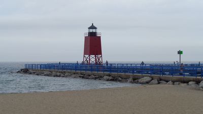
Charlevoix South Pier Light Station, Lake Michigan lighthouse in Charlevoix, United States.

Description

Charlevoix South Pier Light Station is a 12-meter steel skeletal tower with an enclosed upper section located at the end of the south pier entrance to the harbor. The structure operates using a fifth-order Fresnel lens that produces red flashes every four seconds to guide boats safely through the waterway.

History

This lighthouse was built in 1948 to replace the original structure from 1884 that stood on the north pier, reflecting changing maritime safety needs. The new tower incorporated materials and components from its predecessor into its design.

Culture

This lighthouse marks the harbor entrance and serves as a visual landmark that connects the town to Lake Michigan's maritime traditions. Local boaters and fishermen recognize it as a familiar guide that has guided generations of visitors to the waterfront.

Practical

This lighthouse is visible from the waterfront and best visited during daylight hours when you can see the tower details and observe the harbor activity. It is advisable to explore the area during calm weather to safely walk the pier and get the best views of the structure.

Did you know?

This structure was added to the National Register of Historic Places in 2005, recognizing its importance as a navigation aid for the region. This designation has helped protect it as a cultural landmark that represents local maritime heritage.

Location
Inception
1948
Height
12 m
GPS coordinates
45.32028,-85.26500
Latest update
December 12, 2025 12:01

AroundUs brings together thousands of curated places, local tips, and hidden gems, enriched daily by 60,000 contributors worldwide. Discover all places nearby (Charlevoix).

Around this place
Ernest Hemingway Cottage
United States of America

Ernest Hemingway Cottage

21.3 km
Fisherman's Island State Park
United States of America

Fisherman's Island State Park

9.1 km
Young State Park
United States of America

Young State Park

19.6 km
Odawa Casino Resort
United States of America

Odawa Casino Resort

22.7 km
US 31–Island Lake Outlet Bridge
United States of America

US 31–Island Lake Outlet Bridge

516 m
Greensky Hill church
United States of America

Greensky Hill church

6.3 km
J. M. Wells House
United States of America

J. M. Wells House

24.4 km
Mt. McSauba Site
United States of America

Mt. McSauba Site

2.1 km
John J. and Eva Reynier Porter Estate
United States of America

John J. and Eva Reynier Porter Estate

17.7 km
St. Francis Solanus Mission
United States of America

St. Francis Solanus Mission

24.1 km
John Kabler House
United States of America

John Kabler House

24 km
Shafer's Grocery and Residence
United States of America

Shafer's Grocery and Residence

24.5 km
George Schantz House and Store
United States of America

George Schantz House and Store

24.3 km
Pine River Site
United States of America

Pine River Site

318 m
Jacob Miller House
United States of America

Jacob Miller House

24.2 km
Grace Methodist Episcopal Church
United States of America

Grace Methodist Episcopal Church

23.8 km
Boyne City Central Historic District
United States of America

Boyne City Central Historic District

23.1 km
Sarah Pennington House
United States of America

Sarah Pennington House

23.8 km
Boyne City Water Works Building
United States of America

Boyne City Water Works Building

23.5 km
Isaac Bartram House
United States of America

Isaac Bartram House

24.4 km
O'Neill Site
United States of America

O'Neill Site

7.3 km
A. Malin House
United States of America

A. Malin House

24.3 km
Horton Bay School
United States of America

Horton Bay School

15.3 km
Charlevoix City Park Site
United States of America

Charlevoix City Park Site

659 m
Elias Meyers House
United States of America

Elias Meyers House

24.4 km
W. S. Carmichael House
United States of America

W. S. Carmichael House

24.2 km
Frank Lesher House
United States of America

Frank Lesher House

24.4 km
Earl Young Gnome Houses
United States of America

Earl Young Gnome Houses

284 m
Show the full map
« Charlevoix South Pier Light Station - Lake Michigan lighthouse in Charlevoix, United States » is provided by Around Us (aroundus.com). Images and texts are derived from Wikimedia project under a Creative Commons license. You are allowed to copy, distribute, and modify copies of this page, under the conditions set by the license, as long as this note is clearly visible.

Discover hidden gems everywhere you go!

From secret cafés to breathtaking viewpoints, skip the crowded tourist spots and find places that match your style. Our app makes it easy with voice search, smart filtering, route optimization, and insider tips from travelers worldwide. Download now for the complete mobile experience.

Around Us App Screenshot

A unique approach to discovering new places

Le Figaro

All the places worth exploring

France Info

A tailor-made excursion in just a few clicks

20 Minutes

Around Us
Travel Guide & Maps
Download

Send to your phone

QR Code
1

Open the camera app on your mobile.

2

Point at the QR code with your camera. A notification will appear.

3

Tap the notification to open the link.