Enable Location

We need your location to show you interesting places around you

Discover nearby places

Find interesting locations and hidden gems around you

Precise directions

Get accurate directions and distances to places

Your location is never shared with other users. It's only used when you tap the location button.

Contoocook Railroad Bridge

Log in to your account

Start exploring — it's free

Trusted by 61,900 travelers worldwide

Continue with Google
Continue with Apple
or

We will send you a code to connect

By continuing, you accept our Terms and Conditions and our Privacy Policy

Check your inbox

We've sent a pincode in your inbox. Please enter the code below.

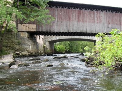
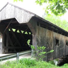
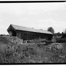
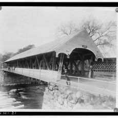
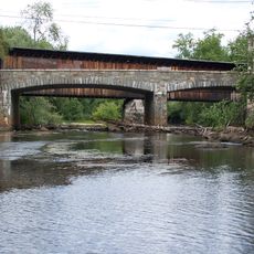
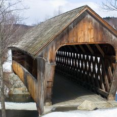
Contoocook Railroad Bridge, Covered railway bridge in Contoocook, United States.

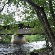
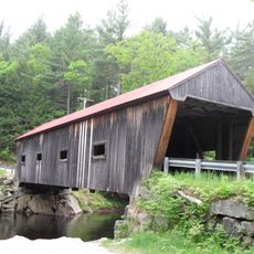
The Contoocook Railroad Bridge is a covered railway structure made of wood that crosses the Contoocook River using a double Town lattice truss design. The wooden roof and framework reflect the classic construction methods used for bridges of this type in the 1800s.

The bridge was built in 1849 and underwent major reconstruction in 1889, originally designed for the Concord and Claremont Railroad. The Boston and Maine Railroad later added it to their expanding network.

The bridge demonstrates how rail transportation shaped the region's economy and brought communities together through trade routes. Walking across it, you sense the connection between the town and the waterway that made this location valuable for industry.

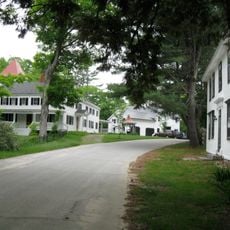
You can reach the bridge through a municipal parking area located near the Contoocook Railroad Museum and local shops. The access is straightforward, making it easy to explore the structure on foot.

This structure is the oldest surviving covered railroad bridge in the United States and retains engineering elements from the 1889 reconstruction. Its long life demonstrates the quality of craftsmanship from that era.

The community of curious travelers

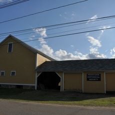
AroundUs brings together thousands of curated places, local tips, and hidden gems, enriched daily by 60,000 contributors worldwide.

Start exploring
Location
Inception
1849
GPS coordinates
43.22306,-71.71417
Latest update
December 12, 2025 12:03
Around this place
Hannah Duston Memorial State Historic Site
United States of America

Hannah Duston Memorial State Historic Site

12.4 km
White Farm
United States of America

White Farm

13.1 km
Pleasant View Home
United States of America

Pleasant View Home

13 km
Stanley Tavern
United States of America

Stanley Tavern

4.8 km
Waterloo Historic District
United States of America

Waterloo Historic District

13.5 km
Waterloo Covered Bridge
United States of America

Waterloo Covered Bridge

13.6 km
Rowell's Covered Bridge
United States of America

Rowell's Covered Bridge

4.4 km
Dalton Covered Bridge
United States of America

Dalton Covered Bridge

9.9 km
Old Webster Meeting House
United States of America

Old Webster Meeting House

11.9 km
New Hampshire Telephone Museum
United States of America

New Hampshire Telephone Museum

10.3 km
Blossom Hill and Calvary Cemeteries
United States of America

Blossom Hill and Calvary Cemeteries

13 km
New Henniker Bridge
United States of America

New Henniker Bridge

5.5 km
William H. Long Memorial
United States of America

William H. Long Memorial

5 km
Boscawen Public Library
United States of America

Boscawen Public Library

12.9 km
Millville School
United States of America

Millville School

11.7 km
Morrill-Lassonde House
United States of America

Morrill-Lassonde House

12.4 km
Upton-Morgan State Forest
United States of America

Upton-Morgan State Forest

13 km
North Weare Schoolhouse
United States of America

North Weare Schoolhouse

12.8 km
Howe-Quimby House
United States of America

Howe-Quimby House

7.3 km
First Congregational Church of Boscawen
United States of America

First Congregational Church of Boscawen

13 km
Lower Warner Meetinghouse
United States of America

Lower Warner Meetinghouse

9 km
Amos Chase House and Mill
United States of America

Amos Chase House and Mill

13 km
Rolfe Barn
United States of America

Rolfe Barn

12.1 km
Henniker Town Hall
United States of America

Henniker Town Hall

10.3 km
Contoocook Covered Bridge
United States of America

Contoocook Covered Bridge

14 m
Contoocook Road Bridge
United States of America

Contoocook Road Bridge

12 m
Henniker Covered Bridge
United States of America

Henniker Covered Bridge

10.3 km
Edna Dean Proctor Bridge
United States of America

Edna Dean Proctor Bridge

10 km
Show the full map
« Contoocook Railroad Bridge - Covered railway bridge in Contoocook, United States » is provided by Around Us (aroundus.com). Images and texts are derived from Wikimedia project under a Creative Commons license. You are allowed to copy, distribute, and modify copies of this page, under the conditions set by the license, as long as this note is clearly visible.

Discover hidden gems everywhere you go!

From secret cafés to breathtaking viewpoints, skip the crowded tourist spots and find places that match your style. Our app makes it easy with voice search, smart filtering, route optimization, and insider tips from travelers worldwide. Download now for the complete mobile experience.

Around Us App Screenshot

A unique approach to discovering new places

Le Figaro

All the places worth exploring

France Info

A tailor-made excursion in just a few clicks

20 Minutes

Around Us
Travel Guide & Maps
Download

Send to your phone

QR Code
1

Open the camera app on your mobile.

2

Point at the QR code with your camera. A notification will appear.

3

Tap the notification to open the link.