Enable Location

We need your location to show you interesting places around you

Discover nearby places

Find interesting locations and hidden gems around you

Precise directions

Get accurate directions and distances to places

Your location is never shared with other users. It's only used when you tap the location button.

Rowell's Covered Bridge

Log in to your account

Start exploring — it's free

Trusted by 62,373 travelers worldwide

Continue with Google
Continue with Apple
or

We will send you a code to connect

By continuing, you accept our Terms and Conditions and our Privacy Policy

Check your inbox

We've sent a pincode in your inbox. Please enter the code below.

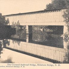
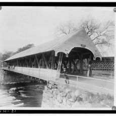
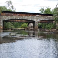
Rowell's Covered Bridge, pont américain

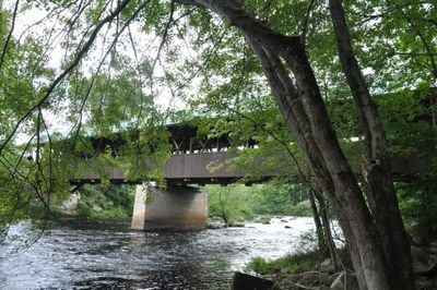
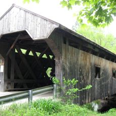
Rowell's Covered Bridge is a straightforward wooden structure that spans the Contoocook River in Hopkinton, supported by two large trusses with a metal roof protecting the framework inside. The sides are lined with dark wooden boards, and the design incorporates solid timber arches that add both strength and a decorative quality to the span.

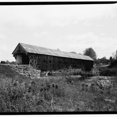
The original bridge was built in the 1800s but was destroyed by a flood and rebuilt in the early 1850s with a Long truss design enhanced by solid timber arches. Builder Horace Childs, a skilled carpenter from Henniker, created these distinctive arches that became a hallmark of his bridge-building work across New England.

The bridge bears the Rowell family name, who settled in the area in the late 1700s and shaped the local community through farming and mill operations. Today it remains a connection between residents and this early period of settlement, embodying how the community was once linked to the river and the land.

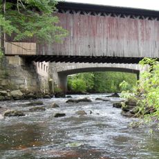
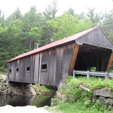
The bridge is open to cars and pedestrians with no marked weight restrictions, making it easy to cross at your own pace. The roof provides shade and protection from weather, while the open sides offer clear views of the river and surrounding area as you walk or drive through.

The roof and open sides let in light and air to protect the wood from rot while framing clear views of the river below. The wooden planks creak softly underfoot, a tactile reminder of the craftsmanship and age of the structure that most visitors remember long after leaving.

The community of curious travelers

AroundUs brings together thousands of curated places, local tips, and hidden gems, enriched daily by 60,000 contributors worldwide.

Start exploring
Location
Architects
Stephen Harriman Long
GPS coordinates
43.19261,-71.74874
Latest update
February 9, 2026 11:07
Around this place
Contoocook Railroad Bridge
United States of America

Contoocook Railroad Bridge

4.4 km
Clough State Park
United States of America

Clough State Park

12.8 km
White Farm
United States of America

White Farm

15.3 km
Pleasant View Home
United States of America

Pleasant View Home

15.4 km
Hillsborough Railroad Bridge
United States of America

Hillsborough Railroad Bridge

14.8 km
Stanley Tavern
United States of America

Stanley Tavern

6.1 km
Waterloo Historic District
United States of America

Waterloo Historic District

13.7 km
Waterloo Covered Bridge
United States of America

Waterloo Covered Bridge

13.7 km
Dalton Covered Bridge
United States of America

Dalton Covered Bridge

10.7 km
Old Webster Meeting House
United States of America

Old Webster Meeting House

15.5 km
New Hampshire Telephone Museum
United States of America

New Hampshire Telephone Museum

11.1 km
New Henniker Bridge
United States of America

New Henniker Bridge

1.2 km
William H. Long Memorial
United States of America

William H. Long Memorial

6.2 km
Millville School
United States of America

Millville School

14.2 km
Contoocook Mills Industrial District
United States of America

Contoocook Mills Industrial District

14.8 km
Upton-Morgan State Forest
United States of America

Upton-Morgan State Forest

14.9 km
North Weare Schoolhouse
United States of America

North Weare Schoolhouse

9.1 km
Gov. John Butler Smith House
United States of America

Gov. John Butler Smith House

14.7 km
Howe-Quimby House
United States of America

Howe-Quimby House

5.5 km
Weare Town House
United States of America

Weare Town House

10.9 km
Lower Warner Meetinghouse
United States of America

Lower Warner Meetinghouse

10 km
Amos Chase House and Mill
United States of America

Amos Chase House and Mill

9.3 km
Henniker Town Hall
United States of America

Henniker Town Hall

6.3 km
Contoocook Covered Bridge
United States of America

Contoocook Covered Bridge

4.4 km
Contoocook Road Bridge
United States of America

Contoocook Road Bridge

4.4 km
Henniker Covered Bridge
United States of America

Henniker Covered Bridge

6.4 km
Edna Dean Proctor Bridge
United States of America

Edna Dean Proctor Bridge

6.1 km
Weare Reservoir
United States of America

Weare Reservoir

10.9 km
Show the full map
« Rowell's Covered Bridge - pont américain » is provided by Around Us (aroundus.com). Images and texts are derived from Wikimedia project under a Creative Commons license. You are allowed to copy, distribute, and modify copies of this page, under the conditions set by the license, as long as this note is clearly visible.

Discover hidden gems everywhere you go!

From secret cafés to breathtaking viewpoints, skip the crowded tourist spots and find places that match your style. Our app makes it easy with voice search, smart filtering, route optimization, and insider tips from travelers worldwide. Download now for the complete mobile experience.

Around Us App Screenshot

A unique approach to discovering new places

Le Figaro

All the places worth exploring

France Info

A tailor-made excursion in just a few clicks

20 Minutes

Around Us
Travel Guide & Maps
Download

Send to your phone

QR Code
1

Open the camera app on your mobile.

2

Point at the QR code with your camera. A notification will appear.

3

Tap the notification to open the link.