Enable Location

We need your location to show you interesting places around you

Discover nearby places

Find interesting locations and hidden gems around you

Precise directions

Get accurate directions and distances to places

Your location is never shared with other users. It's only used when you tap the location button.

Duluth South Breakwater Inner Light

Log in to your account

Start exploring — it's free

Trusted by 62,385 travelers worldwide

Continue with Google
Continue with Apple
or

We will send you a code to connect

By continuing, you accept our Terms and Conditions and our Privacy Policy

Check your inbox

We've sent a pincode in your inbox. Please enter the code below.

Duluth South Breakwater Inner Light

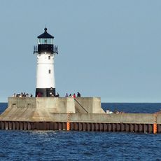
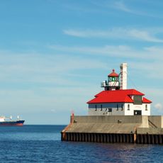
Duluth South Breakwater Inner Light, Lighthouse at the Duluth Ship Canal entrance, Minnesota, US

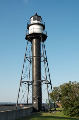
Duluth South Breakwater Inner Light is a brick tower standing 20.5 meters tall at the end of the south breakwater where Lake Superior meets the Duluth Ship Canal. The structure was built to guide vessels safely into the canal and remains a working navigational aid.

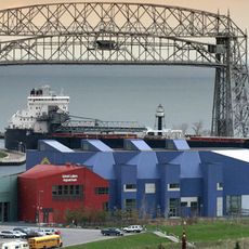
The lighthouse was built in 1889 to help ships navigate the entry to the Duluth harbor during the height of Great Lakes shipping. It was later added to the National Register of Historic Places for its historical significance to regional maritime commerce.

The lighthouse represents Duluth's deep connection to shipping and the Great Lakes, showing how the city's identity has always revolved around water commerce. It stands as a reminder of the people and vessels that have relied on this location for safe passage.

The best time to visit is during clear weather when the entire south breakwater is easily walkable and the tower is visible from a distance. Parking is available near the Aerial Lift Bridge, which serves as a convenient starting point for the walk out to the lighthouse.

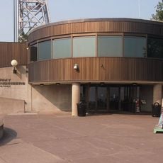
The original fourth-order Fresnel lens that operated inside the tower until 1995 is now displayed at the Lake Superior Maritime Visitor Center nearby. Visitors can examine this important piece of maritime technology and understand how it worked to guide ships safely into port.

The community of curious travelers

AroundUs brings together thousands of curated places, local tips, and hidden gems, enriched daily by 60,000 contributors worldwide.

Start exploring
Location
Inception
1889
Height
20.5 m
GPS coordinates
46.77872,-92.09203
Latest update
December 14, 2025 11:02
Around this place
Aerial Lift Bridge
United States of America

Aerial Lift Bridge

65 m
William A. Irvin
United States of America

William A. Irvin

601 m
Enger Tower
United States of America

Enger Tower

2.5 km
Duluth Ship Canal
United States of America

Duluth Ship Canal

89 m
Lake Superior Railroad Museum
United States of America

Lake Superior Railroad Museum

953 m
Great Lakes Aquarium
United States of America

Great Lakes Aquarium

634 m
John A. Blatnik Bridge
United States of America

John A. Blatnik Bridge

3.4 km
Lake Superior Maritime Visitor Center
United States of America

Lake Superior Maritime Visitor Center

179 m
Duluth Harbor North Pier Light
United States of America

Duluth Harbor North Pier Light

392 m
Kitchi Gammi Club
United States of America

Kitchi Gammi Club

1.9 km
Oliver G. Traphagen House
United States of America

Oliver G. Traphagen House

2.8 km
Tweed Museum of Art
United States of America

Tweed Museum of Art

4.5 km
Duluth South Breakwater Outer Light
United States of America

Duluth South Breakwater Outer Light

378 m
Starkey House
United States of America

Starkey House

4.2 km
Chester Terrace
United States of America

Chester Terrace

2.4 km
Sacred Heart Cathedral, Sacred Heart School and Christian Brothers Home
United States of America

Sacred Heart Cathedral, Sacred Heart School and Christian Brothers Home

1.4 km
Duluth Public Library
United States of America

Duluth Public Library

1.2 km
Duluth Civic Center Historic District
United States of America

Duluth Civic Center Historic District

1.2 km
St. Mark's African Methodist Episcopal Church
United States of America

St. Mark's African Methodist Episcopal Church

2 km
Lincoln Branch Library
United States of America

Lincoln Branch Library

3.1 km
North Shore Scenic Railroad
United States of America

North Shore Scenic Railroad

932 m
United States of America

Endion School

3.2 km
Duluth Masonic Center
United States of America

Duluth Masonic Center

1.2 km
YWCA of Duluth
United States of America

YWCA of Duluth

1.2 km
Pilgrim Congregational Church
United States of America

Pilgrim Congregational Church

3.9 km
William A Irvin Museum
United States of America

William A Irvin Museum

601 m
Munger Terrace
United States of America

Munger Terrace

1.5 km
Lyric Theatre, 114-116 West Superior Street
United States of America

Lyric Theatre, 114-116 West Superior Street

960 m
Show the full map
« Duluth South Breakwater Inner Light - Lighthouse at the Duluth Ship Canal entrance, Minnesota, US » is provided by Around Us (aroundus.com). Images and texts are derived from Wikimedia project under a Creative Commons license. You are allowed to copy, distribute, and modify copies of this page, under the conditions set by the license, as long as this note is clearly visible.

Discover hidden gems everywhere you go!

From secret cafés to breathtaking viewpoints, skip the crowded tourist spots and find places that match your style. Our app makes it easy with voice search, smart filtering, route optimization, and insider tips from travelers worldwide. Download now for the complete mobile experience.

Around Us App Screenshot

A unique approach to discovering new places

Le Figaro

All the places worth exploring

France Info

A tailor-made excursion in just a few clicks

20 Minutes

Around Us
Travel Guide & Maps
Download

Send to your phone

QR Code
1

Open the camera app on your mobile.

2

Point at the QR code with your camera. A notification will appear.

3

Tap the notification to open the link.