·

Enable Location

We need your location to show you interesting places around you

Discover nearby places

Find interesting locations and hidden gems around you

Precise directions

Get accurate directions and distances to places

Your location is never shared with other users. It's only used when you tap the location button.

Vorderer Tajakopf

Log in to your account

Start exploring — it's free

Trusted by 62,661 travelers worldwide

Continue with Google
Continue with Apple
or

We will send you a code to connect

By continuing, you accept our Terms and Conditions and our Privacy Policy

Check your inbox

We've sent a pincode in your inbox. Please enter the code below.

Vorderer Tajakopf

Vorderer Tajakopf, Mountain summit in Imst District, Austria.

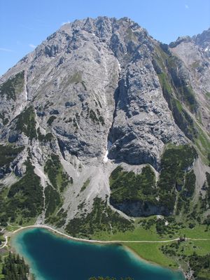
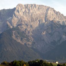
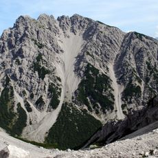
Vorderer Tajakopf is a mountain summit in the Mieming Range rising to 2450 meters. The peak displays a prominent north-south ridge marked by limestone outcrops and deep gullies carved into its slopes.

The summit was first climbed on August 16, 1894, by mountaineers O. v. Unterrichter, J. Gampl, and G. Beyrer. This early ascent marks an important moment in the climbing history of the region.

The mountain name reflects the Germanic alpine naming tradition, incorporating geographical features and local terminology into its designation.

The climb starts near Coburger Hut on trail 812 heading toward Hintere Taja Törl. The final section to the summit involves rocky terrain and demands sure-footedness and a head for heights.

A via ferrata route runs along the western flank and was installed in 2000. This secured climbing path offers views toward Seebensee and provides more technical climbing options beyond the standard trail.

The community of curious travelers

AroundUs brings together thousands of curated places, local tips, and hidden gems, enriched daily by 60,000 contributors worldwide.

Start exploring
Location
Elevation above the sea
2,450 m
Part of
Mieming Range
GPS coordinates
47.36399,10.94739
Latest update
December 13, 2025 17:02
« Vorderer Tajakopf - Mountain summit in Imst District, Austria » is provided by Around Us (aroundus.com). Images and texts are derived from Wikimedia project under a Creative Commons license. You are allowed to copy, distribute, and modify copies of this page, under the conditions set by the license, as long as this note is clearly visible.

Discover hidden gems everywhere you go!

From secret cafés to breathtaking viewpoints, skip the crowded tourist spots and find places that match your style. Our app makes it easy with voice search, smart filtering, route optimization, and insider tips from travelers worldwide. Download now for the complete mobile experience.

Around Us App Screenshot

A unique approach to discovering new places

Le Figaro

All the places worth exploring

France Info

A tailor-made excursion in just a few clicks

20 Minutes

Around Us
Travel Guide & Maps
Download

Send to your phone

QR Code
1

Open the camera app on your mobile.

2

Point at the QR code with your camera. A notification will appear.

3

Tap the notification to open the link.