Cime du Simon, Mountain summit in Provence-Alpes-Côte d'Azur, France
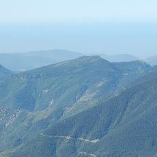
Cime du Simon is a mountain summit in the southern French Alps rising to about 1261 meters in elevation. The route to the top follows grassy slopes, and the summit provides sweeping views of surrounding valleys and ridges.
The mountain first appeared in documented surveys during the 18th century when French military engineers systematically mapped the Alpine region. These early expeditions created the foundation for mapping the broader area and understanding its geography.
Shepherds continue to guide their flocks across the grassy slopes during warmer months, a daily practice that shapes how the landscape looks and feels. This herding tradition remains visible to visitors who encounter grazing animals and their pathways while hiking.
Proper hiking boots and gear are essential since the climb follows steep grassy slopes where footing can be uneven. The summit takes several hours to reach by foot, but mountain weather can shift quickly so plan your timing accordingly.
The rocks at this summit display layered formations from the Jurassic period, revealing how the Alps developed over millions of years. Observant hikers can spot these colored stone layers clearly and see tangible evidence of ancient geological processes at work.
The community of curious travelers
AroundUs brings together thousands of curated places, local tips, and hidden gems, enriched daily by 60,000 contributors worldwide.