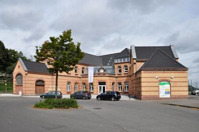
Stolberg Central Station, Architectural heritage monument in Stolberg, Germany.
Stolberg Central Station is a late 19th-century railway station in Stolberg, North Rhine-Westphalia, built in solid brick in the Keilbahnhof style. Multiple rail lines branch outward from the central building, giving the station its characteristic wedge-shaped layout.
The station opened in 1888 and quickly linked Stolberg to three separate railway lines running toward Monchengladbach, Walheim, and Herzogenrath. Its central role in the regional rail network grew alongside the local mining and metalworking industries.
The brick walls and old waiting halls still carry the feel of a working industrial town from over a century ago. Travelers passing through today can notice how the building was designed to handle heavy daily traffic rather than just occasional passengers.
The station sits in the center of Stolberg and is easy to reach on foot from the main shopping streets. Passengers are advised to check the departure boards early, as the multiple branching lines can cause confusion about platforms.
The Keilbahnhof design was a practical solution from the 19th century that allowed several railway lines to share one station building without requiring a large site. Very few examples of this layout survive in Germany today, which makes this station worth a closer look for anyone interested in railway architecture.
The community of curious travelers
AroundUs brings together thousands of curated places, local tips, and hidden gems, enriched daily by 60,000 contributors worldwide.