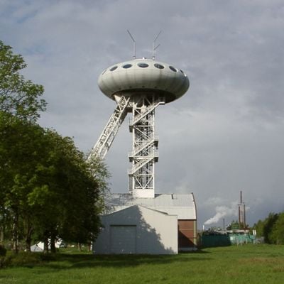
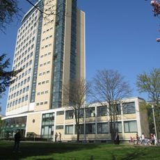
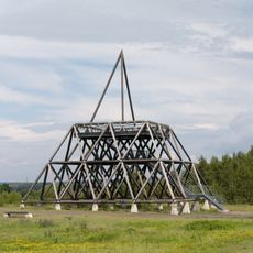
LÜNTEC-Tower, Technology center headframe in Lünen, Germany
The LÜNTEC-Tower is a converted coal mine headframe that now serves as a technology center for businesses. The structure contains office spaces, workshops, and meeting areas spread across multiple levels designed for companies and startups.
The original headframe came from the Minister Achenbach coal mine and was converted to a technology center in 1995 after coal operations ended in 1990. This repurposing marked the region's shift toward new industries following the close of mining.
The tower represents how the Ruhr region transformed from coal mining into modern business and technology. Visitors can see this shift embodied in how the old industrial structure now houses contemporary companies.
The site is accessible during business hours and has parking available on the grounds. It is helpful to call ahead to learn which areas are open to visitors.
A UFO-shaped business lounge at the top level offers panoramic views across Lünen and serves as a conference space. The unusual form of this rounded structure perched on the old framework creates a striking contrast between industrial past and present use.
Location: Lünen
GPS coordinates: 51.60460,7.45323
Latest update: December 10, 2025 15:50
Zeche Waltrop
2.7 km
Christoph 8
4.5 km
Geschwister-Scholl-Gesamtschule Lünen
4.8 km
Haus Buddenburg
2.4 km
Haus Wilbring
1.2 km
Selimiye-Moschee Lünen
4.2 km
Grävingholz
4.6 km
Napoleonsbuche Gahmen
3.4 km
St. Johann Baptist
2.9 km
Süggel
4.7 km
Bergarbeiter-Wohnmuseum
1.1 km
Rathaus
4.8 km
St. Peter
4.5 km
Amtsgericht Lünen
4.6 km
Herz-Jesu-Kirche
4.8 km
Im Siesack
4.4 km
Schloßmühle Lippholthausen
1.7 km
Villa Urbahn
4.7 km
Herz-Jesu-Kirche (Brambauer)
1.3 km
Auf dem Brink
4.6 km
Lippeaue von Lünen bis Schleuse Horst
2.6 km
Groppenbruch
3.3 km
Herrentheyer Wald (Holzkamp)
3.1 km
Spurwerkturm
2.6 km
Freibad Brambauer
477 m
LSG-Waldgebiet suedoestlich der Heikenberg- Siedlung in Luenen-Alstedde
3.2 km
LSG-Gelte, noerdlich des Lippedeiches, suedlich der Alstedder Strasse und suedwestlich der Klaeranlage
3.8 km
Landschaftsschutzgebiet Schwieringhausen, Holthausen, Kemminghausen
4 kmVisited this place? Tap the stars to rate it and share your experience / photos with the community! Try now! You can cancel it anytime.
Discover hidden gems everywhere you go!
From secret cafés to breathtaking viewpoints, skip the crowded tourist spots and find places that match your style. Our app makes it easy with voice search, smart filtering, route optimization, and insider tips from travelers worldwide. Download now for the complete mobile experience.
A unique approach to discovering new places❞
— Le Figaro
All the places worth exploring❞
— France Info
A tailor-made excursion in just a few clicks❞
— 20 Minutes