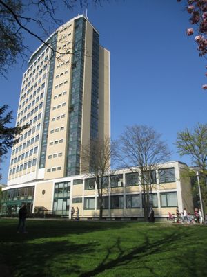
Rathaus, Municipal building in Lünen, Germany
The Rathaus is a 14-story municipal building standing 54 meters tall in central Lünen. It serves as the main administrative headquarters, housing city offices and the council chamber for local governance.
Architects Werner Rausch and Siegfried Stein won a competition among 80 participants to design this building, which opened in October 1960. Their winning design shaped Lünen's post-war urban landscape and became a defining structure for the city.
The building received recognition as a Big Beautiful Building during the European Heritage Year 2018, marking its importance as an architectural landmark for the region. This acknowledgment shows how residents and visitors view it as a symbol of civic identity today.
The building is accessible by bus from the nearby Bäckerstraße station and sits centrally within the city core. Access to interior areas can vary, so it is worth checking ahead if you plan to visit specific sections.
A Paternoster elevator system operates within the building, a rare type of continuous-moving lift that is now restricted to staff use. This technical feature shows how mid-20th century innovations have been preserved in this structure.
Location: Lünen
GPS coordinates: 51.61416,7.52096
Latest update: December 14, 2025 18:45
Schloss Schwansbell
1.6 km
Christoph 8
657 m
Haus Buddenburg
3.1 km
Seepark Lünen
2.6 km
Selimiye-Moschee Lünen
801 m
St. Marien
283 m
Napoleonsbuche Gahmen
2.8 km
Alte Kaffeerösterei
1.2 km
Heinz-Hilpert-Theater
553 m
Evangelische Stadtkirche Lünen
258 m
Kantine Westfalia
2.5 km
Museum der Stadt Lünen
1.7 km
Ziegelei Siegeroth
2.7 km
Amtsgericht Lünen
387 m
Herz-Jesu-Kirche
425 m
Villa Urbahn
86 m
Jüdischer Friedhof
960 m
Synagoge (Lünen)
265 m
Christuskirche (Lünen)
2.8 km
Lippeaue von Wethmar bis Lünen
3 km
Persiluhr
419 m
Stadtarchiv Lünen
73 m
LSG-Waldgebiet suedoestlich der Heikenberg- Siedlung in Luenen-Alstedde
2.5 km
Landschaftsschutzgebiet Geist und Hof Schulze Wethmar, nördlich der Lippe, südlich der Münsterstraße, östlich der Eisenhütte Westfalia
3.1 km
LSG-Gelte, noerdlich des Lippedeiches, suedlich der Alstedder Strasse und suedwestlich der Klaeranlage
1.9 km
LSG-Lippeaue, nordoestlich der STEAG, noerdlich der Moltkestrasse
1.4 km
In den Kämpen, Im Mersche und Langerner Hufeisen
2.8 km
Schulzentrum Altlünen
2 kmVisited this place? Tap the stars to rate it and share your experience / photos with the community! Try now! You can cancel it anytime.
Discover hidden gems everywhere you go!
From secret cafés to breathtaking viewpoints, skip the crowded tourist spots and find places that match your style. Our app makes it easy with voice search, smart filtering, route optimization, and insider tips from travelers worldwide. Download now for the complete mobile experience.
A unique approach to discovering new places❞
— Le Figaro
All the places worth exploring❞
— France Info
A tailor-made excursion in just a few clicks❞
— 20 Minutes