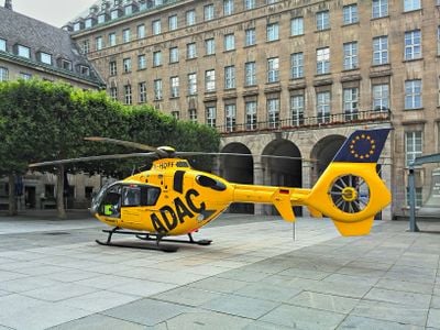
Christoph 8, Rescue helicopter in North Rhine-Westphalia, Germany.
Christoph 8 is a rescue helicopter based in Essen that serves emergency medical calls across the industrial regions of western North Rhine-Westphalia. The aircraft operates with a crew of pilots, emergency doctors, and paramedics working together to reach patients quickly.
Christoph 8 was established in the 1970s as part of Germany's expansion of air rescue services throughout the country. It has since become a standard part of emergency response infrastructure in the region.
The helicopter represents Germany's systematic approach to emergency medical services, integrating air rescue into the comprehensive healthcare infrastructure.
The base is located near Essen/Mülheim airport for quick takeoffs, and the helicopter can launch within minutes of receiving a call. Response times depend on the distance to the emergency location and weather conditions in the region.
The helicopter is named Christoph after a patron saint, a naming convention shared by many other rescue aircraft throughout the German-speaking region. This unified naming system creates immediate recognition for patients and rescue personnel in emergency situations.
Website: https://luftrettung.adac.de/stationen/christoph-8
GPS coordinates: 51.61861,7.51472
Latest update: December 12, 2025 09:01
Schloss Schwansbell
2.3 km
Haus Buddenburg
2.6 km
Seepark Lünen
3.3 km
Selimiye-Moschee Lünen
1.1 km
St. Marien
499 m
Napoleonsbuche Gahmen
3 km
Alte Kaffeerösterei
1 km
Heinz-Hilpert-Theater
1.2 km
Evangelische Stadtkirche Lünen
908 m
Rathaus
657 m
Kantine Westfalia
2.8 km
Museum der Stadt Lünen
2.3 km
Ziegelei Siegeroth
2.9 km
Amtsgericht Lünen
922 m
Herz-Jesu-Kirche
1.1 km
Schloßmühle Lippholthausen
3 km
Villa Urbahn
603 m
Jüdischer Friedhof
1.2 km
Synagoge (Lünen)
908 m
Lippeaue von Lünen bis Schleuse Horst
3 km
Persiluhr
719 m
Stadtarchiv Lünen
687 m
LSG-Waldgebiet suedoestlich der Heikenberg- Siedlung in Luenen-Alstedde
1.9 km
LSG-Gelte, noerdlich des Lippedeiches, suedlich der Alstedder Strasse und suedwestlich der Klaeranlage
1.3 km
Landschaftsschutzgebiet Weege, Beckhof, nördlich der Münsterstraße, südlich der Bahnlinie und beiderseits des Kiliansbaches
3.3 km
LSG-Lippeaue, nordoestlich der STEAG, noerdlich der Moltkestrasse
917 m
In den Kämpen, Im Mersche und Langerner Hufeisen
3 km
Schulzentrum Altlünen
1.6 kmVisited this place? Tap the stars to rate it and share your experience / photos with the community! Try now! You can cancel it anytime.
Discover hidden gems everywhere you go!
From secret cafés to breathtaking viewpoints, skip the crowded tourist spots and find places that match your style. Our app makes it easy with voice search, smart filtering, route optimization, and insider tips from travelers worldwide. Download now for the complete mobile experience.
A unique approach to discovering new places❞
— Le Figaro
All the places worth exploring❞
— France Info
A tailor-made excursion in just a few clicks❞
— 20 Minutes