Chest opened
+${chestReward.xp} XP
Explorer
NOUVEAU ×${chestReward.collectible.quantity}
tapez pour fermer
Chest locked

Open chests in the app

Around Us is built for your phone — chests unlock when you walk, explore and capture nearby places.

Enable Location

We need your location to show you interesting places around you

Discover nearby places

Find interesting locations and hidden gems around you

Precise directions

Get accurate directions and distances to places

Your location is never shared with other users. It's only used when you tap the location button.

Nürnberger Reichswald

Log in to your account

Start exploring — it's free

Trusted by 73,005 travelers worldwide

Continue with Google
Continue with Apple
or

We will send you a code to connect

By continuing, you accept our Terms and Conditions and our Privacy Policy

Check your inbox

We've sent a pincode in your inbox. Please enter the code below.

Nürnberger Reichswald
Discussion Reviews 1 Photos
12.4k Popularity

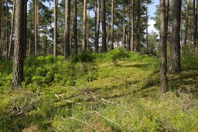
Nürnberger Reichswald, Protected forest near Nuremberg, Germany.

The Nürnberger Reichswald is an expansive forest spanning the region between Nuremberg, Roth, Nürnberger Land, and Erlangen-Höchstadt in Bavaria. The woodland encompasses multiple sections with varied vegetation and provides access from different surrounding communities to its network of trails.

During the Holy Roman Empire, this forest received direct imperial protection and management. This status as a imperial woodland shaped the landscape for centuries and established management traditions that continue to influence how the forest is cared for today.

The Sebalder section takes its name from Saint Sebald and reflects how local religious traditions have shaped the relationship with these woods. Visitors can sense this connection as they walk, where the saint's presence remains woven into the land's identity.

The forest is accessible from multiple entry points in the surrounding municipalities, with trails offering different levels of difficulty. It helps to plan your route beforehand, as the size of the woodland means exploring without a clear path can become confusing.

The forest maintains the administrative structure it had during imperial times, making it one of the few surviving examples of such organization. This continuity in management has shaped how the landscape looks and changes across the centuries.

The community of curious travelers

AroundUs brings together thousands of curated places, local tips, and hidden gems, enriched daily by 60,000 contributors worldwide.

Start exploring
Location
Location
Location
GPS coordinates
49.49710,11.18480
Latest update
March 20, 2026 16:37
Around this place
Evang.-Luth. Pfarrkirche St. Maria Magdalena in Behringersdorf
Germany

Evang.-Luth. Pfarrkirche St. Maria Magdalena in Behringersdorf

2.3 km
Germany

Grabhügel in Schwaig bei Nürnberg

1.5 km
Germany

Grabhügel in Behringersdorfer Forst

1.4 km
Wirtschaftshof in Schwaig
Germany

Wirtschaftshof in Schwaig

2.3 km
Gräber in Behringersdorfer Forst
Germany

Gräber in Behringersdorfer Forst

1.4 km
Germany

Brandgräber in Schwaig bei Nürnberg

2.3 km
Germany

Ehem. Forsthaus (Wildmeisterhaus) in Schwaig

2.1 km
Germany

Bauernhof, Bauernhaus in Schwaig

2.3 km
Germany

Wohnhaus in Schwaig

2.1 km
Germany

Cultural heritage D-5-6433-0066 Erlenstegener Forst

2.1 km
Germany

Siedlung in Behringersdorfer Forst

1.9 km
Germany

Siedlung in Schwaig bei Nürnberg

1.8 km
Germany

Siedlung in Behringersdorfer Forst

1.7 km
Messnerhaus in Schwaig
Germany

Messnerhaus in Schwaig

2.3 km
Germany

Scheune Schwaiger Straße 3 (D-5-74-156-17#2)

2.3 km
Herrensitz in Schwaig
Germany

Herrensitz in Schwaig

2.3 km
Germany

Wohnhaus in Schwaig

2.2 km
Germany

Ehem. Wohnstallhaus in Schwaig

2.2 km
Germany

Kriegerdenkmal in Schwaig

2.2 km
Germany

Backhaus Schwaiger Straße 3 (D-5-74-156-17#1)

2.3 km
Schloss in Schwaig
Germany

Schloss in Schwaig

2.3 km
Germany

Friedhofsmauer Schwaiger Straße 14 (D-5-74-156-20#1)

2.3 km
Germany

Schloss Schwaiger Straße 20 (D-5-74-156-26#1)

2.3 km
Germany

Mauer Schwaiger Straße 22 (D-5-74-156-26#2)

2.3 km
Germany

Schloss Schürstabstraße 5; Schürstabstraße 9 (D-5-74-156-26#3)

2.3 km
Germany

Ehem. Wohnstallhaus in Schwaig

2.3 km
Germany

Field monument in Gemeindefreies Gebiet Erlenstegener Forst (D-5-6533-0201)

2.3 km
Germany

Field monument in Gemeindefreies Gebiet Behringersdorfer Forst (D-5-6533-0200)

1.8 km
Show the full map
Reviews
Share your experience

No review yet

Discussions
Start a discussion...

No discussion yet

« Nürnberger Reichswald - Protected forest near Nuremberg, Germany » is provided by Around Us (aroundus.com). Images and texts are derived from Wikimedia project under a Creative Commons license. You are allowed to copy, distribute, and modify copies of this page, under the conditions set by the license, as long as this note is clearly visible.

Discover hidden gems everywhere you go!

From secret cafés to breathtaking viewpoints, skip the crowded tourist spots and find places that match your style. Our app makes it easy with voice search, smart filtering, route optimization, and insider tips from travelers worldwide. Download now for the complete mobile experience.

Around Us App Screenshot

A unique approach to discovering new places

Le Figaro

All the places worth exploring

France Info

A tailor-made excursion in just a few clicks

20 Minutes

Around Us
Travel Guide & Maps
Download

Send to your phone

QR Code
1

Open the camera app on your mobile.

2

Point at the QR code with your camera. A notification will appear.

3

Tap the notification to open the link.