Enable Location

We need your location to show you interesting places around you

Discover nearby places

Find interesting locations and hidden gems around you

Precise directions

Get accurate directions and distances to places

Your location is never shared with other users. It's only used when you tap the location button.

Höllental

Log in to your account

Start exploring — it's free

Trusted by 65,547 travelers worldwide

Continue with Google
Continue with Apple
or

We will send you a code to connect

By continuing, you accept our Terms and Conditions and our Privacy Policy

Check your inbox

We've sent a pincode in your inbox. Please enter the code below.

Discussion Reviews 1 Photos
10.3k Popularity

Höllental, Valley and geotope in Lichtenberg, Germany.

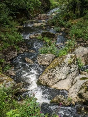
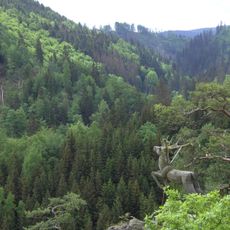
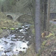
Höllental is a river valley and geotope in the Franconian Forest near Lichtenberg, carved by the Selbitz River. The valley walls rise steeply on both sides, exposing layers of rock that geologists recognize as part of a broader formation stretching across this part of Bavaria.

The Selbitz River gradually cut through the rock of the Fichtel Mountains over a very long period, forming the valley as it exists today. The rocks in the walls date back even further, to a time of volcanic activity that predates the river's work entirely.

The valley is popular with hikers who follow the river path and stop to look at the exposed rock faces up close. The name Höllental, meaning 'hell valley' in German, likely refers to how dark and narrow the gorge feels in certain sections.

The valley can be reached from several entry points, with parking near the camping area making it a common starting spot. Marked trails run along the river and through the rocky sections, so it is easy to find your way without specialized equipment.

The rocky walls contain pillow lava formations, rounded shapes that form when lava flows into water and cools rapidly. Their presence here tells geologists that this area was once covered by a shallow sea, long before the river or the forest existed.

The community of curious travelers

AroundUs brings together thousands of curated places, local tips, and hidden gems, enriched daily by 60,000 contributors worldwide.

Start exploring
Location
Elevation above the sea
433 m
Length
3,000 m
Width
1,000 m
Accessibility
Wheelchair limited access
GPS coordinates
50.37950,11.69214
Latest update
March 3, 2026 10:12
Reviews
Share your experience

No review yet

Discussions
Start a discussion...

No discussion yet

« Höllental - Valley and geotope in Lichtenberg, Germany » is provided by Around Us (aroundus.com). Images and texts are derived from Wikimedia project under a Creative Commons license. You are allowed to copy, distribute, and modify copies of this page, under the conditions set by the license, as long as this note is clearly visible.

Discover hidden gems everywhere you go!

From secret cafés to breathtaking viewpoints, skip the crowded tourist spots and find places that match your style. Our app makes it easy with voice search, smart filtering, route optimization, and insider tips from travelers worldwide. Download now for the complete mobile experience.

Around Us App Screenshot

A unique approach to discovering new places

Le Figaro

All the places worth exploring

France Info

A tailor-made excursion in just a few clicks

20 Minutes

Around Us
Travel Guide & Maps
Download

Send to your phone

QR Code
1

Open the camera app on your mobile.

2

Point at the QR code with your camera. A notification will appear.

3

Tap the notification to open the link.