Friedenspark, Public park in Neustadt-Süd, Cologne, Germany
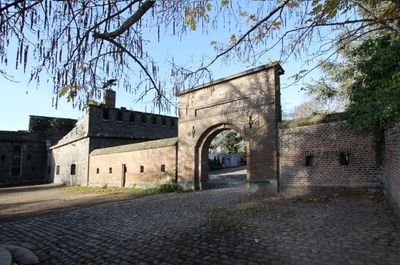
Friedenspark is a roughly 4.5-hectare green space in Neustadt-Süd with winding paths and dense vegetation that incorporates the remains of Fort I, an old military fortress. The ruins of the former fortification and its moats are woven into the modern park layout, creating distinct areas and boundaries throughout the site.
Landscape designer Fritz Encke transformed the military fortress into a public green space in 1914, preserving the original fortification structures within the new design. This conversion marked the site's shift from strategic outpost to a recreational area for the city's residents.
The park's name reflects its role as a space dedicated to peace, expressed through its various memorials and monuments. Visitors experience how this green area serves as a place for quiet contemplation and remembrance.
The park has multiple entrances along Agrippinaufer, Oberländer Wall, and Alteburger Straße, making it accessible from different directions. Visitors can find designated grilling areas, sports facilities, and a youth center throughout the grounds.
In 2012, a modern memorial featuring basalt stones embedded in the ground was installed to honor John Lennon's peace anthem 'Imagine'. This subtle installation connects the musical legacy of the peace activist to the park's existing commemorative purpose.
The community of curious travelers
AroundUs brings together thousands of curated places, local tips, and hidden gems, enriched daily by 60,000 contributors worldwide.