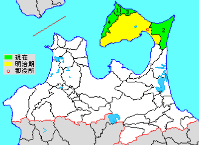
Shimokita District, district in Aomori prefecture, Japan
Location: Aomori Prefecture
Inception: October 30, 1878
Shares border with: Mutsu
GPS coordinates: 41.28333,141.21667
Latest update: March 3, 2025 22:03
Mount Osore
11.4 km
Trappistine Convent
65.1 km
Shinoridate
63 km
Hollow Dogū
67.2 km
Mount Kamafuse
8.1 km
Bodai-ji
11.1 km
Shiriyazaki Lighthouse
26.2 km
Hakodate Arena
66.2 km
Mutsu Science Museum
9.1 km
Hakodate Park
67.2 km
Esanmisaki Lighthouse
59.3 km
Hakodate City Museum
67.2 km
Mutaku-ji
53.1 km
Esan Prefectural Natural Park
59.3 km
Kōya-ji
66.9 km
Yogoshiyama Forest Park
44.9 km
Miharashi Park
66.3 km
Hotoke-ga-ura
34.6 km
Honganji hakodate betsu-in
67.5 km
Shōbō-ji
67.4 km
Monpō-ji
51.2 km
Noheji Town Library
47.2 km
Daruma Falls
53.2 km
Kōsetsu-en
66.4 km
Asamushi Dam
53 km
Ōmazaki Lighthouse
39.5 km
Mount E
58.2 km
Asamushi Aquarium
52.2 kmReviews
Visited this place? Tap the stars to rate it and share your experience / photos with the community! Try now! You can cancel it anytime.
Discover hidden gems everywhere you go!
From secret cafés to breathtaking viewpoints, skip the crowded tourist spots and find places that match your style. Our app makes it easy with voice search, smart filtering, route optimization, and insider tips from travelers worldwide. Download now for the complete mobile experience.
A unique approach to discovering new places❞
— Le Figaro
All the places worth exploring❞
— France Info
A tailor-made excursion in just a few clicks❞
— 20 Minutes