Enable Location

We need your location to show you interesting places around you

Discover nearby places

Find interesting locations and hidden gems around you

Precise directions

Get accurate directions and distances to places

Your location is never shared with other users. It's only used when you tap the location button.

Log in to your account

Start exploring — it's free

Trusted by 62,883 travelers worldwide

Continue with Google
Continue with Apple
or

We will send you a code to connect

By continuing, you accept our Terms and Conditions and our Privacy Policy

Check your inbox

We've sent a pincode in your inbox. Please enter the code below.

伝法大橋
Discussion Reviews Photo
2.1k Popularity

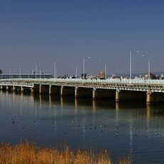
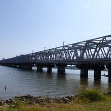
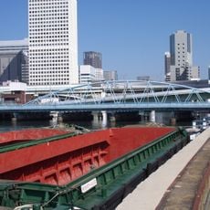
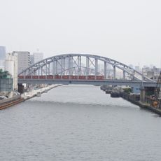
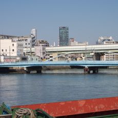
伝法大橋, Steel road bridge between Nishiyodogawa-ku and Konohana-ku, Japan

The Denpo Bridge is a steel structure crossing 765 meters in length and 17 meters in width to connect two Osaka districts. The bridge accommodates vehicle lanes alongside pedestrian and bicycle paths, functioning as a key transportation link between the areas.

The bridge was built in 1942 as part of the industrial expansion of the Osaka region, reflecting infrastructure goals of that era. Since its construction, it has served as a reliable link between the two districts while maintaining its original steel framework.

The structure links everyday life for people living on both sides, creating a shared passage that residents cross multiple times a week as part of their normal routines. This daily movement through the bridge is how the two districts maintain their practical connection.

The bridge offers clear separation between vehicle lanes and paths for pedestrians and cyclists, making crossing straightforward for all users. Visitors should wear sturdy shoes when walking across and expect moderate activity during peak hours.

The structure maintains its original steel framework from its year of construction, demonstrating the durability of Japanese engineering techniques from the mid-twentieth century. Architecture enthusiasts often stop to examine the details of this framework while crossing.

The community of curious travelers

AroundUs brings together thousands of curated places, local tips, and hidden gems, enriched daily by 60,000 contributors worldwide.

Start exploring
Location
Location
Inception
January 1942
Length
765.1 m
Width
17 m
GPS coordinates
34.69266,135.44751
Latest update
December 13, 2025 17:04
« 伝法大橋 - Steel road bridge between Nishiyodogawa-ku and Konohana-ku, Japan » is provided by Around Us (aroundus.com). Images and texts are derived from Wikimedia project under a Creative Commons license. You are allowed to copy, distribute, and modify copies of this page, under the conditions set by the license, as long as this note is clearly visible.

Discover hidden gems everywhere you go!

From secret cafés to breathtaking viewpoints, skip the crowded tourist spots and find places that match your style. Our app makes it easy with voice search, smart filtering, route optimization, and insider tips from travelers worldwide. Download now for the complete mobile experience.

Around Us App Screenshot

A unique approach to discovering new places

Le Figaro

All the places worth exploring

France Info

A tailor-made excursion in just a few clicks

20 Minutes

Around Us
Travel Guide & Maps
Download

Send to your phone

QR Code
1

Open the camera app on your mobile.

2

Point at the QR code with your camera. A notification will appear.

3

Tap the notification to open the link.