Enable Location

We need your location to show you interesting places around you

Discover nearby places

Find interesting locations and hidden gems around you

Precise directions

Get accurate directions and distances to places

Your location is never shared with other users. It's only used when you tap the location button.

Water tower at Pionerskaia Street

Log in to your account

Start exploring — it's free

Trusted by 62,491 travelers worldwide

Continue with Google
Continue with Apple
or

We will send you a code to connect

By continuing, you accept our Terms and Conditions and our Privacy Policy

Check your inbox

We've sent a pincode in your inbox. Please enter the code below.

Water tower at Pionerskaia Street

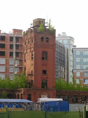
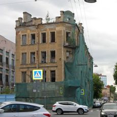
Water tower at Pionerskaia Street, Regional cultural heritage water tower in Saint Petersburg, Russia

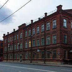
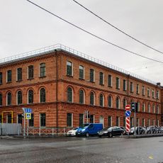
The water tower at Pionerskaia Street is a brick industrial structure that displays design features typical of early twentieth-century municipal buildings in Saint Petersburg. It served as part of a larger production facility and functioned as a water supply system for the area.

The structure was built between 1911 and 1915 as part of an industrial facility and reflects the water supply engineering of that era. Its construction represents the industrial expansion that Saint Petersburg experienced in the early twentieth century.

The tower reflects how the city's industrial growth shaped its neighborhoods during the early 1900s, with its sturdy brick form becoming part of the local landscape. Residents would have seen such structures as ordinary parts of urban life, marking the expansion of modern services.

The building sits at an intersection where two streets meet, making it easy to locate and observe from the surrounding area. Visitors interested in industrial buildings and urban history can view the structure while walking through the neighborhood.

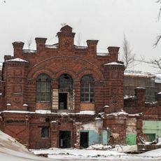
The tower was part of a production facility owned by the Leontev Brothers, a company that played a quiet role in the city's industrial development. This connection reveals how smaller enterprises contributed to infrastructure during that period.

The community of curious travelers

AroundUs brings together thousands of curated places, local tips, and hidden gems, enriched daily by 60,000 contributors worldwide.

Start exploring
Location
GPS coordinates
59.96278,30.27042
Latest update
December 14, 2025 17:42
Around this place
Betancourt Bridge
Russian Federation

Betancourt Bridge

865 m
Red Banner Textile Factory
Russian Federation

Red Banner Textile Factory

803 m
Dinamo Stadium
Russian Federation

Dinamo Stadium

608 m
Petrovsky
Russian Federation

Petrovsky

1.3 km
Bolshoy Petrovsky Bridge
Russian Federation

Bolshoy Petrovsky Bridge

905 m
Dom veteranov Stseny
Russian Federation

Dom veteranov Stseny

829 m
Saint-Petersburg Institute of History
Russian Federation

Saint-Petersburg Institute of History

1.2 km
Little Nevka
Russian Federation

Little Nevka

314 m
Lazarevskiy Bridge
Russian Federation

Lazarevskiy Bridge

339 m
Bolshoi Krestovskii bridge
Russian Federation

Bolshoi Krestovskii bridge

730 m
Petrovsky Park
Russian Federation

Petrovsky Park

767 m
Kalinin plant historic buildings
Russian Federation

Kalinin plant historic buildings

1.4 km
Malo-Petrovsky bridge
Russian Federation

Malo-Petrovsky bridge

210 m
Molodyozhny Bridge
Russian Federation

Molodyozhny Bridge

899 m
Malo-Krestovskii bridge
Russian Federation

Malo-Krestovskii bridge

1.3 km
Мост Красного Курсанта
Russian Federation

Мост Красного Курсанта

1 km
4-й Ждановский мост
Russian Federation

4-й Ждановский мост

619 m
3rd Parkovy bridge
Russian Federation

3rd Parkovy bridge

1.2 km
2-й Парковый мост
Russian Federation

2-й Парковый мост

1.2 km
Barochny Bridge
Russian Federation

Barochny Bridge

1.2 km
Zhdanovka Embankment 9, Zhdanovka Embankment 9, Meisner Revenue House
Russian Federation

Zhdanovka Embankment 9, Zhdanovka Embankment 9, Meisner Revenue House

1.4 km
Zhdanovsky Bridge
Russian Federation

Zhdanovsky Bridge

1.4 km
Sernyi Bridge
Russian Federation

Sernyi Bridge

928 m
Преображенская церковь в Колтовской слободе
Russian Federation

Преображенская церковь в Колтовской слободе

173 m
Пионерская, 36
Russian Federation

Пионерская, 36

503 m
Сборочно-снаряжательная мастерская
Russian Federation

Сборочно-снаряжательная мастерская

1.3 km
Меднолитейная мастерская
Russian Federation

Меднолитейная мастерская

1.4 km
Здание мастерских
Russian Federation

Здание мастерских

1.4 km
Show the full map
« Water tower at Pionerskaia Street - Regional cultural heritage water tower in Saint Petersburg, Russia » is provided by Around Us (aroundus.com). Images and texts are derived from Wikimedia project under a Creative Commons license. You are allowed to copy, distribute, and modify copies of this page, under the conditions set by the license, as long as this note is clearly visible.

Discover hidden gems everywhere you go!

From secret cafés to breathtaking viewpoints, skip the crowded tourist spots and find places that match your style. Our app makes it easy with voice search, smart filtering, route optimization, and insider tips from travelers worldwide. Download now for the complete mobile experience.

Around Us App Screenshot

A unique approach to discovering new places

Le Figaro

All the places worth exploring

France Info

A tailor-made excursion in just a few clicks

20 Minutes

Around Us
Travel Guide & Maps
Download

Send to your phone

QR Code
1

Open the camera app on your mobile.

2

Point at the QR code with your camera. A notification will appear.

3

Tap the notification to open the link.