Enable Location

We need your location to show you interesting places around you

Discover nearby places

Find interesting locations and hidden gems around you

Precise directions

Get accurate directions and distances to places

Your location is never shared with other users. It's only used when you tap the location button.

Rail Bridge over the Iset River, Kamensk-Uralsky

Log in to your account

Start exploring — it's free

Trusted by 63,933 travelers worldwide

Continue with Google
Continue with Apple
or

We will send you a code to connect

By continuing, you accept our Terms and Conditions and our Privacy Policy

Check your inbox

We've sent a pincode in your inbox. Please enter the code below.

Rail Bridge over the Iset River, Kamensk-Uralsky
Discussion Reviews 1 Photos
2.4k Popularity

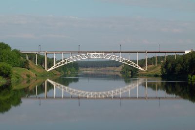
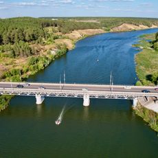
Rail Bridge over the Iset River, Kamensk-Uralsky, Railway bridge in Kamensk-Uralsky, Russia.

The rail bridge crosses the Iset River with its main span reaching about 140 meters across the water. Additional bridge sections extend from both banks to connect the railway to the surrounding terrain.

Construction started in 1938 and finished in 1939 as part of efforts to support transportation for the nearby aluminum plant. The bridge became an important industrial infrastructure project during that period of regional expansion.

The bridge received recognition as a regional cultural heritage site in 2001 through Decree 859 of the Sverdlovsk Oblast Government.

The bridge sits along the Sinarska-Chelyabinsk railway line and can be viewed from accessible points near the city. Best viewing is from safe locations along the railway corridor without stepping onto active tracks.

The bridge uses steel tubes filled with concrete, an experimental construction method from that era. This approach was innovative for its time and demonstrated advanced engineering techniques of the 1930s.

The community of curious travelers

AroundUs brings together thousands of curated places, local tips, and hidden gems, enriched daily by 60,000 contributors worldwide.

Start exploring
Location
Inception
1939
GPS coordinates
56.39306,61.96417
Latest update
December 13, 2025 11:47
Around this place
Kamensk-Uralsky Cannon
Russian Federation

Kamensk-Uralsky Cannon

5.1 km
Drama Number Three
Russian Federation

Drama Number Three

747 m
Savior Transfiguration monastery
Russian Federation

Savior Transfiguration monastery

5.4 km
Dam on the Kamenka river
Russian Federation

Dam on the Kamenka river

5.4 km
Church of the Intercession of the Most Holy Mother of God, Kamensk-Uralsky
Russian Federation

Church of the Intercession of the Most Holy Mother of God, Kamensk-Uralsky

4.8 km
Bridge over Kamenka river
Russian Federation

Bridge over Kamenka river

4.7 km
Ural Aluminum Smelter Proletarian's Group of Houses
Russian Federation

Ural Aluminum Smelter Proletarian's Group of Houses

1.2 km
Merchant Kosyakov’s manor house
Russian Federation

Merchant Kosyakov’s manor house

4.9 km
Molchanov Merchants’ Shop
Russian Federation

Molchanov Merchants’ Shop

4.9 km
House-Estate of the merchant Vorobyov
Russian Federation

House-Estate of the merchant Vorobyov

5.4 km
Warehouses Kamensky plant
Russian Federation

Warehouses Kamensky plant

5.1 km
Estate of the Caretaker of the Kamensk Plant
Russian Federation

Estate of the Caretaker of the Kamensk Plant

5.2 km
Tronin’s House
Russian Federation

Tronin’s House

5.1 km
Church of the Holy Prophet Elijah, Smolinskoye
Russian Federation

Church of the Holy Prophet Elijah, Smolinskoye

20 km
Gerasimov Merchant’s Shop
Russian Federation

Gerasimov Merchant’s Shop

5.1 km
Bureau Kamensky plant
Russian Federation

Bureau Kamensky plant

5.2 km
Church of the Entry of the Theotokos into the Temple
Russian Federation

Church of the Entry of the Theotokos into the Temple

6.2 km
Orphanage building, Kamensk-Uralsky
Russian Federation

Orphanage building, Kamensk-Uralsky

5.4 km
Church of Our Lady of Tikhvin
Russian Federation

Church of Our Lady of Tikhvin

19.1 km
Church of Intercession of the Theotokos
Russian Federation

Church of Intercession of the Theotokos

4.5 km
Gostiny Dvor, Kamensk-Uralsky
Russian Federation

Gostiny Dvor, Kamensk-Uralsky

5 km
The Building of Men’s College, Kamensk-Uralsky
Russian Federation

The Building of Men’s College, Kamensk-Uralsky

5.3 km
The hospital building of Kamensk plant
Russian Federation

The hospital building of Kamensk plant

4.4 km
Holy Trinity Church
Russian Federation

Holy Trinity Church

5.2 km
Байновский мост
Russian Federation

Байновский мост

2.1 km
Здание городской администрации
Russian Federation

Здание городской администрации

3.9 km
Часовня Александра Невского
Russian Federation

Часовня Александра Невского

3.7 km
Volkovskoye Reservoir
Russian Federation

Volkovskoye Reservoir

3 km
Show the full map
Reviews
Share your experience

No review yet

Discussions
Start a discussion...

No discussion yet

« Rail Bridge over the Iset River, Kamensk-Uralsky - Railway bridge in Kamensk-Uralsky, Russia » is provided by Around Us (aroundus.com). Images and texts are derived from Wikimedia project under a Creative Commons license. You are allowed to copy, distribute, and modify copies of this page, under the conditions set by the license, as long as this note is clearly visible.

Discover hidden gems everywhere you go!

From secret cafés to breathtaking viewpoints, skip the crowded tourist spots and find places that match your style. Our app makes it easy with voice search, smart filtering, route optimization, and insider tips from travelers worldwide. Download now for the complete mobile experience.

Around Us App Screenshot

A unique approach to discovering new places

Le Figaro

All the places worth exploring

France Info

A tailor-made excursion in just a few clicks

20 Minutes

Around Us
Travel Guide & Maps
Download

Send to your phone

QR Code
1

Open the camera app on your mobile.

2

Point at the QR code with your camera. A notification will appear.

3

Tap the notification to open the link.