Spurn, Tidal island at East Riding of Yorkshire, England
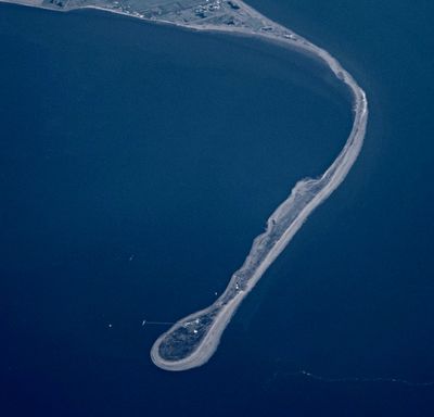
Spurn is a peninsula on the coast of East Riding of Yorkshire that extends about three miles into the North Sea and narrows to just 50 yards (46 meters) wide in places. The land consists of sand and shingle banks shaped by dunes and salt marshes, creating habitats for seabirds and marine life.
The area once held the medieval port of Ravenspurn, which sank beneath the sea due to coastal erosion over several centuries. This transformation by natural forces has shaped how the region is understood as a place of constant change and adaptation.
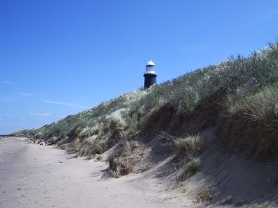
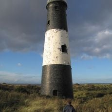
The lighthouse, built in 1895, shapes how people experience this remote headland today. It marks the area's connection to maritime life and shows how communities have maintained a presence on this exposed coastline.
The easiest way to reach the site is by car following the A1033 and B1445 roads. Visiting is possible year-round, but conditions vary as the road becomes partially impassable during high tides.
A storm surge in 2013 temporarily transformed the peninsula into an island, making the road impassable for a time. This event shows how nature and human presence exist here in constant flux.
GPS coordinates: 53.59383,0.13981
Latest update: December 7, 2025 09:26
Humber Forts
9.6 km
Cleethorpes Coast Light Railway
11.5 km
RAF Holmpton
11.1 km
Church of St Helen
2.9 km
St Mary's Church, Welwick
11.1 km
Council House
11.8 km
Birstall Priory
7.9 km
Spurn Lighthouse
2.2 km
Spurn Point Low Light
2.3 km
RAF Holmpton - Visit the Bunker
11.1 km
Empire Theatre, Cleethorpes
11.8 km
Spurn Discovery Centre
2.4 km
Church of All Saints
6.5 km
Church of St Nicholas
11.5 km
Church of St Peter
12 km
Cross Approximately 6 Metres South Of Church Of St Helen
7.7 km
Church of St Helen
7.7 km
World War I acoustic mirror 335m north east of Kilnsea Grange
3.8 km
Ross Castle
11.6 km
Cleethorpes War Memorial
11.9 km
Cleethorpes WWII Memorial Hall
12.2 km
RAF North Coates Strike Wing War Memorial, Cleethorpes
11.6 km
Former Air Raid Shelter To Rear Of Numbers 28 And 30
11.8 km
The Old Vicarage
11.9 km
The Knoll
11.7 km
Railings To Council House Along Cambridge Street Elevation
11.8 km
Cleethorpes Armed Forces Memorial Gate
11.6 km
Tithe Barn
6.5 kmVisited this place? Tap the stars to rate it and share your experience / photos with the community! Try now! You can cancel it anytime.
Discover hidden gems everywhere you go!
From secret cafés to breathtaking viewpoints, skip the crowded tourist spots and find places that match your style. Our app makes it easy with voice search, smart filtering, route optimization, and insider tips from travelers worldwide. Download now for the complete mobile experience.
A unique approach to discovering new places❞
— Le Figaro
All the places worth exploring❞
— France Info
A tailor-made excursion in just a few clicks❞
— 20 Minutes