Enable Location

We need your location to show you interesting places around you

Discover nearby places

Find interesting locations and hidden gems around you

Precise directions

Get accurate directions and distances to places

Your location is never shared with other users. It's only used when you tap the location button.

Thames Barrier

Log in to your account

Start exploring — it's free

Trusted by 61,365 travelers worldwide

Continue with Google
Continue with Apple
or

We will send you a code to connect

By continuing, you accept our Terms and Conditions and our Privacy Policy

Check your inbox

We've sent a pincode in your inbox. Please enter the code below.

Thames Barrier

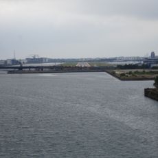
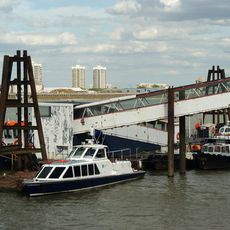
Thames Barrier, Flood barrier in Woolwich, United Kingdom

Description

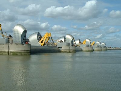
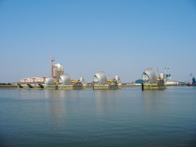
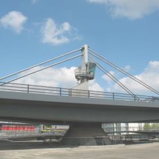
The Thames Barrier sits across the river at Woolwich and consists of ten silvery steel structures that rise like large domes from the water. The gates normally lie flat on the riverbed and allow ship traffic to pass without obstruction.

History

After the great North Sea flood of 1953, the government decided to protect London from flooding. The construction project took eight years and was completed in 1984.

Culture

The barrier shows how London manages its tidal river and builds large infrastructure to keep the city safe from flooding. Visitors can see how engineering becomes part of everyday river life and shapes the waterfront.

Practical

The information center on the south bank provides access to the visitor pavilion where you can view the structure up close. The best views come at high tide when the silhouette appears against the sky.

Did you know?

The system is tested every month, and the gates rotate from their horizontal resting position to vertical. Each gate weighs 3,300 tonnes and is powered by hydraulic motors.

Location
Inception
1984
Height
20.1 m
Length
520 m
GPS coordinates
51.49778,0.03667
Latest update
December 12, 2025 21:07

AroundUs brings together thousands of curated places, local tips, and hidden gems, enriched daily by 60,000 contributors worldwide. Discover all places nearby (London).

Around this place
NHS Nightingale Hospital London
United Kingdom

NHS Nightingale Hospital London

1.2 km
Millennium Mills
United Kingdom

Millennium Mills

956 m
Maryon Park
United Kingdom

Maryon Park

1.1 km
Royal Victoria Dock Bridge
United Kingdom

Royal Victoria Dock Bridge

1.2 km
Thames Barrier Park
United Kingdom

Thames Barrier Park

378 m
Silvertown Quays
United Kingdom

Silvertown Quays

591 m
Brick Lane Music Hall
United Kingdom

Brick Lane Music Hall

698 m
Gilbert's Pit
United Kingdom

Gilbert's Pit

1 km
Barrier Gardens Pier
United Kingdom

Barrier Gardens Pier

423 m
Silvertown War Memorial
United Kingdom

Silvertown War Memorial

649 m
Greenwich Peninsula Ecology Park
United Kingdom

Greenwich Peninsula Ecology Park

1.4 km
Eastern Quay
United Kingdom

Eastern Quay

1 km
The Valley
United Kingdom

The Valley

1.1 km
Church of St Thomas
United Kingdom

Church of St Thomas

1.2 km
Church of St Michael and All Angels
United Kingdom

Church of St Michael and All Angels

1.4 km
Silo D
United Kingdom

Silo D

779 m
War memorial at former St Mark's Church (Brick Lane Music Hall)
United Kingdom

War memorial at former St Mark's Church (Brick Lane Music Hall)

673 m
Former Police Station To Royal Dockyard
United Kingdom

Former Police Station To Royal Dockyard

959 m
The Connaught Tavern
United Kingdom

The Connaught Tavern

1.2 km
Chimney To Steam Factory, Former Royal Dockyard
United Kingdom

Chimney To Steam Factory, Former Royal Dockyard

1 km
Royal Dockyard Clock House (Facing Entrance)
United Kingdom

Royal Dockyard Clock House (Facing Entrance)

1.2 km
Royal Dockyard Gun Emplacements On Riverside To North East Of Entrance And Gunposts Facing
United Kingdom

Royal Dockyard Gun Emplacements On Riverside To North East Of Entrance And Gunposts Facing

1.2 km
Former Siemens Cable Factory, 37 Bowater Road
United Kingdom

Former Siemens Cable Factory, 37 Bowater Road

515 m
Stothert And Pitt Cranes On North And South Sides Of The Royal Victoria Dock
United Kingdom

Stothert And Pitt Cranes On North And South Sides Of The Royal Victoria Dock

1.4 km
153-159, Woodhill Se18
United Kingdom

153-159, Woodhill Se18

1.5 km
Royal Dockyard Entrance Gateway Piers And Abutting Walls
United Kingdom

Royal Dockyard Entrance Gateway Piers And Abutting Walls

1.3 km
Connaught Bridge
United Kingdom

Connaught Bridge

1 km
Royal Dockyard Police Building At East Side Of Entrance Gateway
United Kingdom

Royal Dockyard Police Building At East Side Of Entrance Gateway

1.3 km
Show the full map
« Thames Barrier - Flood barrier in Woolwich, United Kingdom » is provided by Around Us (aroundus.com). Images and texts are derived from Wikimedia project under a Creative Commons license. You are allowed to copy, distribute, and modify copies of this page, under the conditions set by the license, as long as this note is clearly visible.

Discover hidden gems everywhere you go!

From secret cafés to breathtaking viewpoints, skip the crowded tourist spots and find places that match your style. Our app makes it easy with voice search, smart filtering, route optimization, and insider tips from travelers worldwide. Download now for the complete mobile experience.

Around Us App Screenshot

A unique approach to discovering new places

Le Figaro

All the places worth exploring

France Info

A tailor-made excursion in just a few clicks

20 Minutes

Around Us
Travel Guide & Maps
Download

Send to your phone

QR Code
1

Open the camera app on your mobile.

2

Point at the QR code with your camera. A notification will appear.

3

Tap the notification to open the link.