Chest opened
+${chestReward.xp} XP
Explorer
NOUVEAU ×${chestReward.collectible.quantity}
tapez pour fermer
Chest locked

Open chests in the app

Around Us is built for your phone — chests unlock when you walk, explore and capture nearby places.

Enable Location

We need your location to show you interesting places around you

Discover nearby places

Find interesting locations and hidden gems around you

Precise directions

Get accurate directions and distances to places

Your location is never shared with other users. It's only used when you tap the location button.

Log in to your account

Start exploring — it's free

Trusted by 72,876 travelers worldwide

Continue with Google
Continue with Apple
or

We will send you a code to connect

By continuing, you accept our Terms and Conditions and our Privacy Policy

Check your inbox

We've sent a pincode in your inbox. Please enter the code below.

Heathrow
Discussion Reviews Photo
18.2k Popularity

Heathrow, Former settlement in London Borough of Hillingdon, England.

Heathrow was a former settlement that stretched along Heathrow Road with small holdings, farms, and orchards spanning about a mile and a half. The place consisted of three main farm areas: Heathrow Hall, Perrotts Farm, and Perry Oaks, which together formed the center of local farming.

The settlement was first recorded as La Hetherewe in 1453 and existed until its complete demolition in 1944 to make way for the airport. The shift from farmland to a modern aviation hub marked the end of a farming community that had lasted for centuries.

The agricultural community relied on market gardening and used horse-drawn carts to move produce to London markets. This way of farming shaped daily life and the settlement's rhythm for generations.

The site no longer exists at its original location since the area lies beneath the airport grounds. Visitors can learn more about the former settlement only through original sites like the location of King's Arbor or historical records.

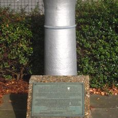
General William Roy used the King's Arbor orchard as a reference point for baseline measurements during the Anglo-French Survey between 1784 and 1790. This early surveying work helped create precise maps of England and France.

The community of curious travelers

AroundUs brings together thousands of curated places, local tips, and hidden gems, enriched daily by 60,000 contributors worldwide.

Start exploring
GPS coordinates
51.46730,-0.45290
Latest update
December 8, 2025 08:21
Around this place
Compass Centre
United Kingdom

Compass Centre

1.9 km
Queens Building, Heathrow
United Kingdom

Queens Building, Heathrow

453 m
St George’s Interdenominational Chapel, Heathrow Airport
United Kingdom

St George’s Interdenominational Chapel, Heathrow Airport

361 m
Slipstream
United Kingdom

Slipstream

346 m
Grow Heathrow
United Kingdom

Grow Heathrow

2.6 km
Church of St Mary
United Kingdom

Church of St Mary

2.2 km
Harlington Locomotive Society
United Kingdom

Harlington Locomotive Society

2.7 km
Skyteam Lounge Terminal 4
United Kingdom

Skyteam Lounge Terminal 4

863 m
Church of St Mary
United Kingdom

Church of St Mary

1.9 km
Monument at north-western end of General Roy's survey base
United Kingdom

Monument at north-western end of General Roy's survey base

1.3 km
Green Man Public House
United Kingdom

Green Man Public House

2.5 km
King Henry Public House  The Stables
United Kingdom

King Henry Public House The Stables

2.7 km
The King William IV Public House
United Kingdom

The King William IV Public House

2.6 km
The Swan Public House
United Kingdom

The Swan Public House

2.2 km
Perry Green
United Kingdom

Perry Green

2.1 km
Lanz Farmhouse
United Kingdom

Lanz Farmhouse

2.5 km
Burlington House  and Flanking Walls Of Burlington House
United Kingdom

Burlington House and Flanking Walls Of Burlington House

2 km
Bedfont war memorial
United Kingdom

Bedfont war memorial

2.1 km
Stanwell War Memorial
United Kingdom

Stanwell War Memorial

2.2 km
Lord Knyvett's Free School
United Kingdom

Lord Knyvett's Free School

1.9 km
Gates Piers And Gates To Stanwell Place
United Kingdom

Gates Piers And Gates To Stanwell Place

2.7 km
Milestone 13 Miles From London
United Kingdom

Milestone 13 Miles From London

2.1 km
Milestone
United Kingdom

Milestone

2.2 km
Milestone, Bath Road; Harlington Corner (was Coach & Horses corner, later Arial Hotel)
United Kingdom

Milestone, Bath Road; Harlington Corner (was Coach & Horses corner, later Arial Hotel)

1.9 km
Milestone, Bath Road; Harmondsworth, near Sipson Lane N side of Heathrow Airport
United Kingdom

Milestone, Bath Road; Harmondsworth, near Sipson Lane N side of Heathrow Airport

1.6 km
Milestone, High Street, opp. The Swan PH, W of jct with Oaks Road
United Kingdom

Milestone, High Street, opp. The Swan PH, W of jct with Oaks Road

2.5 km
Milestone, Bath Road; Heathrow Park, E of village (was opp. Peggy Bedford Inn); 100m into Old Bath Road from Jct. with Colnbrook By-pass
United Kingdom

Milestone, Bath Road; Heathrow Park, E of village (was opp. Peggy Bedford Inn); 100m into Old Bath Road from Jct. with Colnbrook By-pass

2.5 km
Milestone, Staines Road; Bedfont, by No. 778, 50m E of Ashford boundary
United Kingdom

Milestone, Staines Road; Bedfont, by No. 778, 50m E of Ashford boundary

2.3 km
Show the full map
Reviews
Share your experience

No review yet

Discussions
Start a discussion...

No discussion yet

« Heathrow - Former settlement in London Borough of Hillingdon, England » is provided by Around Us (aroundus.com). Images and texts are derived from Wikimedia project under a Creative Commons license. You are allowed to copy, distribute, and modify copies of this page, under the conditions set by the license, as long as this note is clearly visible.

Discover hidden gems everywhere you go!

From secret cafés to breathtaking viewpoints, skip the crowded tourist spots and find places that match your style. Our app makes it easy with voice search, smart filtering, route optimization, and insider tips from travelers worldwide. Download now for the complete mobile experience.

Around Us App Screenshot

A unique approach to discovering new places

Le Figaro

All the places worth exploring

France Info

A tailor-made excursion in just a few clicks

20 Minutes

Around Us
Travel Guide & Maps
Download

Send to your phone

QR Code
1

Open the camera app on your mobile.

2

Point at the QR code with your camera. A notification will appear.

3

Tap the notification to open the link.