Enable Location

We need your location to show you interesting places around you

Discover nearby places

Find interesting locations and hidden gems around you

Precise directions

Get accurate directions and distances to places

Your location is never shared with other users. It's only used when you tap the location button.

Teddington Lock

Log in to your account

Start exploring — it's free

Trusted by 62,929 travelers worldwide

Continue with Google
Continue with Apple
or

We will send you a code to connect

By continuing, you accept our Terms and Conditions and our Privacy Policy

Check your inbox

We've sent a pincode in your inbox. Please enter the code below.

Teddington Lock
Discussion Reviews 1 Photos 1 Collections
24k Popularity

Teddington Lock, Lock and weir complex on River Thames in Richmond upon Thames, England

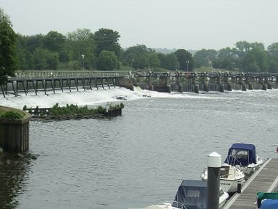
Teddington Lock is a complex of locks and weir on the River Thames between Ham and Teddington in the London Borough of Richmond upon Thames. The installation contains three separate chambers: a launch lock measuring 54 m (177 ft), a skiff lock of 15 m (49 ft), and a barge lock extending 198 m (650 ft).

Construction began in 1810 to improve navigation on the lower river and regulate water levels. A major rebuild in 1857 replaced the original timber structure with more durable stone.

The site takes its name from the nearby area and showcases typical Victorian-era waterway engineering still visible across many canal and river installations in the region. On weekends, local residents walk along the towpaths while boat owners pass through the different chambers.

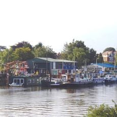
The installation functions as the lowest full-tide lock on the Thames, marking the transition between tidal river and managed waterway. Pedestrians can cross the entire complex using the footbridges while observing lock operations from above.

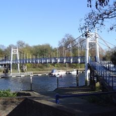
Two Grade II listed footbridges built in 1888 span the entire site and allow visitors to watch the lock gates during operation. The site served as a gathering point for small vessels during the 1940 Dunkirk evacuation before they departed for the French coast.

The community of curious travelers

AroundUs brings together thousands of curated places, local tips, and hidden gems, enriched daily by 60,000 contributors worldwide.

Start exploring
GPS coordinates
51.43150,-0.32390
Latest update
December 20, 2025 13:20
Navigation locks: hydraulic structures, dams, and boat lifts

Navigation locks are engineering structures that enable ships to pass through significant elevation changes between seas, lakes, and rivers. From the Panama Canal, where vessels rise 86 feet (26 meters) to cross the Isthmus, to the Three Gorges Dam in China, featuring five-stage locks managing a...

Reviews
Share your experience

No review yet

Discussions
Start a discussion...

No discussion yet

« Teddington Lock - Lock and weir complex on River Thames in Richmond upon Thames, England » is provided by Around Us (aroundus.com). Images and texts are derived from Wikimedia project under a Creative Commons license. You are allowed to copy, distribute, and modify copies of this page, under the conditions set by the license, as long as this note is clearly visible.

Discover hidden gems everywhere you go!

From secret cafés to breathtaking viewpoints, skip the crowded tourist spots and find places that match your style. Our app makes it easy with voice search, smart filtering, route optimization, and insider tips from travelers worldwide. Download now for the complete mobile experience.

Around Us App Screenshot

A unique approach to discovering new places

Le Figaro

All the places worth exploring

France Info

A tailor-made excursion in just a few clicks

20 Minutes

Around Us
Travel Guide & Maps
Download

Send to your phone

QR Code
1

Open the camera app on your mobile.

2

Point at the QR code with your camera. A notification will appear.

3

Tap the notification to open the link.