Chest opened
+${chestReward.xp} XP
Explorer
NOUVEAU ×${chestReward.collectible.quantity}
tapez pour fermer
Chest locked

Open chests in the app

Around Us is built for your phone — chests unlock when you walk, explore and capture nearby places.

Enable Location

We need your location to show you interesting places around you

Discover nearby places

Find interesting locations and hidden gems around you

Precise directions

Get accurate directions and distances to places

Your location is never shared with other users. It's only used when you tap the location button.

M40 motorway

Log in to your account

Start exploring — it's free

Trusted by 72,910 travelers worldwide

Continue with Google
Continue with Apple
or

We will send you a code to connect

By continuing, you accept our Terms and Conditions and our Privacy Policy

Check your inbox

We've sent a pincode in your inbox. Please enter the code below.

M40 motorway
Discussion Reviews 1 Photos
53.7k Popularity

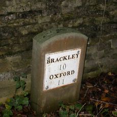
M40 motorway, Major motorway in Warwickshire and Oxfordshire, England

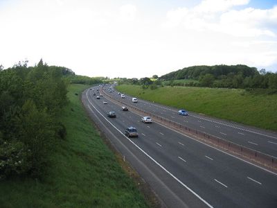
The M40 is a major motorway that links London with Birmingham, passing through Warwickshire, Buckinghamshire, and Oxfordshire. It features three lanes in each direction and serves as a primary transport corridor for vehicles traveling between these regions.

Construction began in 1967 near High Wycombe, with different sections completed gradually until the final stretch opened in 1991. This staged approach allowed the motorway to become a major transport link between London and the Midlands.

The motorway design incorporates environmental considerations, including route modifications near Otmoor wetlands to protect local wildlife and natural habitats.

Four service areas with fuel, food, and rest facilities are located at regular intervals along the route. The motorway is well-signposted, making it easy to navigate exits and entrances throughout the journey.

The route follows ancient trading paths through the Chiltern Hills, navigating significant terrain changes along the way. A notable diversion was planned around the Otmoor wetlands to protect the ecosystem during construction.

The community of curious travelers

AroundUs brings together thousands of curated places, local tips, and hidden gems, enriched daily by 60,000 contributors worldwide.

Start exploring
Location
Location
Location
Inception
1967
GPS coordinates
51.93717,-1.20190
Latest update
December 14, 2025 17:44
Around this place
Middleton Park, Oxfordshire
United Kingdom

Middleton Park, Oxfordshire

4.4 km
United Kingdom

Aves ditch

5.5 km
Church of the Annunciation to the Blessed Virgin Mary
United Kingdom

Church of the Annunciation to the Blessed Virgin Mary

5.6 km
Church of St Peter, Stoke Lyne
United Kingdom

Church of St Peter, Stoke Lyne

2.3 km
Church of St Olave
United Kingdom

Church of St Olave

3.5 km
Church of St Mary
United Kingdom

Church of St Mary

909 m
Church of St Edmund and George
United Kingdom

Church of St Edmund and George

5.1 km
Church of St Mary
United Kingdom

Church of St Mary

5.6 km
Church of St Lawrence
United Kingdom

Church of St Lawrence

3.5 km
Bicester War Memorial
United Kingdom

Bicester War Memorial

5.6 km
Church of All Saints
United Kingdom

Church of All Saints

4 km
Church of St Mary, Chesterton
United Kingdom

Church of St Mary, Chesterton

5.6 km
Church of St Mary
United Kingdom

Church of St Mary

3.9 km
Church of St Peter
United Kingdom

Church of St Peter

1.7 km
Bell Inn
United Kingdom

Bell Inn

5.4 km
Church of St James
United Kingdom

Church of St James

5.6 km
Churchyard Cross Approximately 12 Metres North Of Church Of St James
United Kingdom

Churchyard Cross Approximately 12 Metres North Of Church Of St James

5.6 km
Church of Holy Trinity (Roman Catholic)
United Kingdom

Church of Holy Trinity (Roman Catholic)

4.8 km
Whitmore Arms Public House
United Kingdom

Whitmore Arms Public House

5 km
Trow Pool water tower
United Kingdom

Trow Pool water tower

2 km
Cold War structures at the former Upper Heyford Airbase
United Kingdom

Cold War structures at the former Upper Heyford Airbase

3.6 km
Manor Farmhouse
United Kingdom

Manor Farmhouse

5.6 km
Granary Approximately 30 Metres South East Of Manor Farmhouse
United Kingdom

Granary Approximately 30 Metres South East Of Manor Farmhouse

5.6 km
Milestone, S of turn to village, North of lay-by
United Kingdom

Milestone, S of turn to village, North of lay-by

5.6 km
Milestone, Old Covert, N of Oxford Lodge
United Kingdom

Milestone, Old Covert, N of Oxford Lodge

4.9 km
Milestone, S of Ardley Fields landfill - Manor Farm; 20m N of blocked off exit to old lay-by
United Kingdom

Milestone, S of Ardley Fields landfill - Manor Farm; 20m N of blocked off exit to old lay-by

1.9 km
Milestone, Station Road; between railway bridge and southern edge of Ardley, S of Uplands
United Kingdom

Milestone, Station Road; between railway bridge and southern edge of Ardley, S of Uplands

816 m
Milestone, abandoned section of A43 now forming road to Cottisford, just S of point where break in hedge was once lane to Pimlico Farm
United Kingdom

Milestone, abandoned section of A43 now forming road to Cottisford, just S of point where break in hedge was once lane to Pimlico Farm

4.5 km
Show the full map
Reviews
Share your experience

No review yet

Discussions
Start a discussion...

No discussion yet

« M40 motorway - Major motorway in Warwickshire and Oxfordshire, England » is provided by Around Us (aroundus.com). Images and texts are derived from Wikimedia project under a Creative Commons license. You are allowed to copy, distribute, and modify copies of this page, under the conditions set by the license, as long as this note is clearly visible.

Discover hidden gems everywhere you go!

From secret cafés to breathtaking viewpoints, skip the crowded tourist spots and find places that match your style. Our app makes it easy with voice search, smart filtering, route optimization, and insider tips from travelers worldwide. Download now for the complete mobile experience.

Around Us App Screenshot

A unique approach to discovering new places

Le Figaro

All the places worth exploring

France Info

A tailor-made excursion in just a few clicks

20 Minutes

Around Us
Travel Guide & Maps
Download

Send to your phone

QR Code
1

Open the camera app on your mobile.

2

Point at the QR code with your camera. A notification will appear.

3

Tap the notification to open the link.