Scorhill

Log in to your account

AroundUs is a community-driven map of interesting places, built by curious explorers like you. It grows with every review, story, and photo you share.
Connect to save your favorite spots, contribute locations, and create personalized routes.
By continuing, you accept our Terms and Conditions and our Privacy Policy
Add to collection
Map
Suggest a change
Share

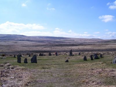
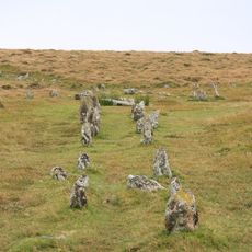
Scorhill, Bronze Age stone circle in Gidleigh Common, Devon, United Kingdom
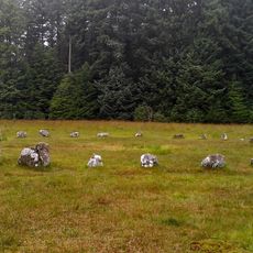
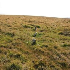
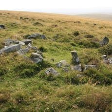
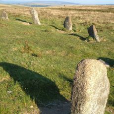
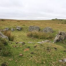
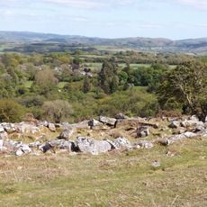
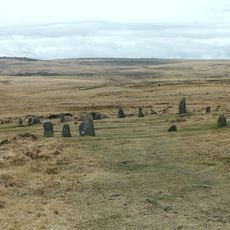
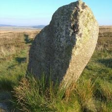
The circle measures 27 meters in diameter and contains 23 standing stones and 11 fallen stones, with heights ranging from 0.85 to 2.25 meters.

During the Bronze Age, inhabitants constructed this circle, which originally contained between 51 and 70 stones, though many were later removed for building local structures.

The center of the circle shows evidence of large fires, while archaeological findings include flint artifacts dating back to the Mesolithic period around 8500 BC.

Visitors can reach the circle by parking at Scorhill Farm and following the marked footpath across Scorhill Down through the Dartmoor National Park.

The tallest standing stone aligns with the setting sun during Midsummer Eve, indicating possible astronomical purposes in its original design.

Location: Devon

GPS coordinates: 50.67060,-3.90542

Latest update: March 10, 2025 12:26

Around this place
Show the full map
Gidleigh Castle
United Kingdom

Gidleigh Castle

1.9 km
Shovel Down
United Kingdom

Shovel Down

1.5 km
Church of the Holy Trinity
United Kingdom

Church of the Holy Trinity

1.9 km
Fernworthy Circle
United Kingdom

Fernworthy Circle

3.3 km
Teignhead Clapper Bridge
United Kingdom

Teignhead Clapper Bridge

3.3 km
Forder Bridge
United Kingdom

Forder Bridge

2.8 km
Providence Methodist Chapel
United Kingdom

Providence Methodist Chapel

2.8 km
South Forder Farmhouse
United Kingdom

South Forder Farmhouse

2.7 km
Footbridge At Sx 664 895
United Kingdom

Footbridge At Sx 664 895

2.3 km
Thorn Cottage
United Kingdom

Thorn Cottage

3.1 km
Water Tower, Stables, Coach House And Cottages Approximately 4 Metres North-East Of Outer Down
United Kingdom

Water Tower, Stables, Coach House And Cottages Approximately 4 Metres North-East Of Outer Down

3 km
Langston Farmhouse North Including Garden Wall Adjoining To Front
United Kingdom

Langston Farmhouse North Including Garden Wall Adjoining To Front

3.3 km
Stone circle 400m south west of Buttern Hill
United Kingdom

Stone circle 400m south west of Buttern Hill

1.2 km
Cross Fragment At Sx 678891
United Kingdom

Cross Fragment At Sx 678891

2.8 km
Thorn Farmhouse And Thorn Farm Cottage
United Kingdom

Thorn Farmhouse And Thorn Farm Cottage

3.1 km
North Forder Farmhouse
United Kingdom

North Forder Farmhouse

2.7 km
A partly enclosed stone hut circle settlement on Kennon Hill
United Kingdom

A partly enclosed stone hut circle settlement on Kennon Hill

2.1 km
Stone circle and cairn 330m south of Little Hound Tor
United Kingdom

Stone circle and cairn 330m south of Little Hound Tor

3.1 km
Round cairn 780m south of the Thirlstone
United Kingdom

Round cairn 780m south of the Thirlstone

2.9 km
Langston Farmhouse (South) Including Garden Walls Adjoining To Front
United Kingdom

Langston Farmhouse (South) Including Garden Walls Adjoining To Front

3.3 km
Two stone hut circles and part of a coaxial field system at Frenchbeer Rock
United Kingdom

Two stone hut circles and part of a coaxial field system at Frenchbeer Rock

2.6 km
Coaxial field system, associated and later remains at Throwleigh Common and Kennon Hill
United Kingdom

Coaxial field system, associated and later remains at Throwleigh Common and Kennon Hill

3.1 km
Gidleigh Mill
United Kingdom

Gidleigh Mill

2.4 km
Sampson Headstone Approximately 2 Metres South-East Of Vestry Of Church Of The Holy Trinity
United Kingdom

Sampson Headstone Approximately 2 Metres South-East Of Vestry Of Church Of The Holy Trinity

1.9 km
Scorhill stone circle, three cairns and a length of reave
United Kingdom

Scorhill stone circle, three cairns and a length of reave

90 m
The North Teign coaxial field system (western part) and associated later remains at Shovel Down, Stonetor Hill and Long Ridge
United Kingdom

The North Teign coaxial field system (western part) and associated later remains at Shovel Down, Stonetor Hill and Long Ridge

1.5 km
Round cairn on Watern Tor
United Kingdom

Round cairn on Watern Tor

2.6 km
White Moor Stone
United Kingdom

White Moor Stone

3 km
Show the full map

Reviews

Visited this place? Tap the stars to rate it and share your experience / photos with the community! Try now! You can cancel it anytime.

« Scorhill: Bronze Age stone circle in Gidleigh Common, Devon, United Kingdom » is provided by Around Us (aroundus.com). Images and texts are derived from Wikimedia project under a Creative Commons license. You are allowed to copy, distribute, and modify copies of this page, under the conditions set by the license, as long as this note is clearly visible.

Discover hidden gems everywhere you go!

From secret cafés to breathtaking viewpoints, skip the crowded tourist spots and find places that match your style. Our app makes it easy with voice search, smart filtering, route optimization, and insider tips from travelers worldwide. Download now for the complete mobile experience.

Around Us App Screenshot

A unique approach to discovering new places

Le Figaro

All the places worth exploring

France Info

A tailor-made excursion in just a few clicks

20 Minutes