Shovel Down

Log in to your account

AroundUs is a community-driven map of interesting places, built by curious explorers like you. It grows with every review, story, and photo you share.
Connect to save your favorite spots, contribute locations, and create personalized routes.
Continue with Google
Continue with Apple
Continue with X
Continue with Facebook
Continue with email
By continuing, you accept our Terms and Conditions and our Privacy Policy
Create an account
Add to collection
Map
Suggest a change
Share

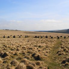
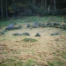
Shovel Down, Stone row and archaeological site in Devon, United Kingdom

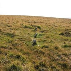
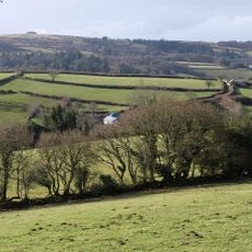
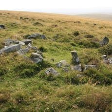
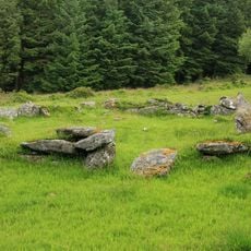
Shovel Down is a stone row located on Dartmoor in Devon, consisting of standing stones arranged in a linear formation at approximately 400 meters (1,300 feet) elevation. The site connects with other prehistoric monuments across the moorland through established walking paths and remains accessible year-round.

The stone row dates to the Neolithic and Bronze Age periods, representing one of southern England's early human settlements and gathering places. Evidence from the site indicates that people used this location for both ceremonial purposes and practical daily activities.

The stone row forms part of a larger complex of prehistoric monuments across Dartmoor, reflecting how early communities structured their sacred and ceremonial spaces.

The site is reached on foot via moorland walking trails that remain open throughout the year, though terrain can become muddy or slippery after rain. Visitors should wear suitable footwear and prepare for changing weather conditions typical of exposed highland areas.

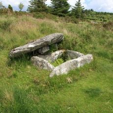
Excavations uncovered a wooden spade preserved underground for around 3,500 years, offering rare insight into prehistoric farming techniques and daily work. This discovery shows how certain organic materials can survive for millennia under specific moorland conditions.

Location: Devon

GPS coordinates: 50.65700,-3.90400

Latest update: December 14, 2025 16:43

Photos
Around this place
Scorhill
United Kingdom

Scorhill

1.5 km
Grey Wethers
United Kingdom

Grey Wethers

3.2 km
Gidleigh Castle
United Kingdom

Gidleigh Castle

3 km
Church of the Holy Trinity
United Kingdom

Church of the Holy Trinity

2.9 km
Fernworthy Circle
United Kingdom

Fernworthy Circle

1.7 km
Teignhead Clapper Bridge
United Kingdom

Teignhead Clapper Bridge

2.1 km
Fernworthy Reservoir
United Kingdom

Fernworthy Reservoir

2.1 km
Footbridge At Sx 664 895
United Kingdom

Footbridge At Sx 664 895

3.8 km
Two stone circles known as The Grey Wethers, three round cairns, two ring cairns and an oval enclosure in Great Stannon Newtake
United Kingdom

Two stone circles known as The Grey Wethers, three round cairns, two ring cairns and an oval enclosure in Great Stannon Newtake

3.2 km
Stone alignment, cairns, enclosed prehistoric settlement and a length of reave on Hurston Ridge
United Kingdom

Stone alignment, cairns, enclosed prehistoric settlement and a length of reave on Hurston Ridge

3.7 km
Water Tower, Stables, Coach House And Cottages Approximately 4 Metres North-East Of Outer Down
United Kingdom

Water Tower, Stables, Coach House And Cottages Approximately 4 Metres North-East Of Outer Down

2.9 km
Thorn Cottage
United Kingdom

Thorn Cottage

3 km
Partially enclosed stone hut circle settlement 780m south west of Metherall
United Kingdom

Partially enclosed stone hut circle settlement 780m south west of Metherall

2.4 km
Cairn and cist on the northern side of Fernworthy Reservoir, 660m north west of Metherall
United Kingdom

Cairn and cist on the northern side of Fernworthy Reservoir, 660m north west of Metherall

2 km
Scorhill stone circle, three cairns and a length of reave
United Kingdom

Scorhill stone circle, three cairns and a length of reave

1.4 km
Stone circle 400m south west of Buttern Hill
United Kingdom

Stone circle 400m south west of Buttern Hill

2.7 km
Round cairn 780m south of the Thirlstone
United Kingdom

Round cairn 780m south of the Thirlstone

2.6 km
Two stone hut circles and part of a coaxial field system at Frenchbeer Rock
United Kingdom

Two stone hut circles and part of a coaxial field system at Frenchbeer Rock

1.7 km
Lower Hurston Farmhouse Including Garden Walls Adjoining To South
United Kingdom

Lower Hurston Farmhouse Including Garden Walls Adjoining To South

3.5 km
Hole Farmhouse
United Kingdom

Hole Farmhouse

3 km
Gidleigh Mill
United Kingdom

Gidleigh Mill

3.4 km
Thorn Farmhouse And Thorn Farm Cottage
United Kingdom

Thorn Farmhouse And Thorn Farm Cottage

3 km
Yardworthy Farmhouse
United Kingdom

Yardworthy Farmhouse

2.5 km
A partly enclosed stone hut circle settlement on Kennon Hill
United Kingdom

A partly enclosed stone hut circle settlement on Kennon Hill

3.4 km
Sampson Headstone Approximately 2 Metres South-East Of Vestry Of Church Of The Holy Trinity
United Kingdom

Sampson Headstone Approximately 2 Metres South-East Of Vestry Of Church Of The Holy Trinity

2.9 km
Stone alignment, hut circle settlement, medieval long house and post-medieval farmstead at Assycombe
United Kingdom

Stone alignment, hut circle settlement, medieval long house and post-medieval farmstead at Assycombe

3.2 km
The North Teign coaxial field system (western part) and associated later remains at Shovel Down, Stonetor Hill and Long Ridge
United Kingdom

The North Teign coaxial field system (western part) and associated later remains at Shovel Down, Stonetor Hill and Long Ridge

256 m
Round cairn on Watern Tor
United Kingdom

Round cairn on Watern Tor

2.8 km
Show the full map
Reviews

Visited this place? Tap the stars to rate it and share your experience / photos with the community! Try now! You can cancel it anytime.

« Shovel Down - Stone row and archaeological site in Devon, United Kingdom » is provided by Around Us (aroundus.com). Images and texts are derived from Wikimedia project under a Creative Commons license. You are allowed to copy, distribute, and modify copies of this page, under the conditions set by the license, as long as this note is clearly visible.

Discover hidden gems everywhere you go!

From secret cafés to breathtaking viewpoints, skip the crowded tourist spots and find places that match your style. Our app makes it easy with voice search, smart filtering, route optimization, and insider tips from travelers worldwide. Download now for the complete mobile experience.

Around Us App Screenshot

A unique approach to discovering new places

Le Figaro

All the places worth exploring

France Info

A tailor-made excursion in just a few clicks

20 Minutes