Enable Location

We need your location to show you interesting places around you

Discover nearby places

Find interesting locations and hidden gems around you

Precise directions

Get accurate directions and distances to places

Your location is never shared with other users. It's only used when you tap the location button.

New Bridge

Log in to your account

Start exploring — it's free

Trusted by 61,886 travelers worldwide

Continue with Google
Continue with Apple
or

We will send you a code to connect

By continuing, you accept our Terms and Conditions and our Privacy Policy

Check your inbox

We've sent a pincode in your inbox. Please enter the code below.

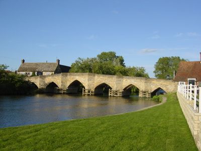
New Bridge, Road bridge in Oxfordshire, England

New Bridge is a stone structure spanning the River Thames with two arches, linking Northmoor and Longworth via the A415 road. The construction features sturdy medieval pillars that support the roadway across the water.

This structure was built in the 13th century and ranks among the two oldest surviving Thames bridges. Its construction reveals how critical this river crossing was for medieval communities.

The name 'New Bridge' is ironic given its medieval origins, reflecting how it was newer than earlier river crossings at the time. Locals and travelers have relied on this crossing for centuries as a key connection between neighboring communities.

The structure is open year-round for vehicles and pedestrians, providing safe passage across the Thames. Traffic can be heavier during peak times, especially when local events occur in the area.

The northern span of the bridge lies permanently submerged beneath the water surface. This unusual feature makes it a rare example of how medieval bridge design adapted to river conditions.

The community of curious travelers

AroundUs brings together thousands of curated places, local tips, and hidden gems, enriched daily by 60,000 contributors worldwide.

Start exploring
Location
Location
GPS coordinates
51.70980,-1.41722
Latest update
December 11, 2025 18:11
Around this place
Devil's Quoits
United Kingdom

Devil's Quoits

3.4 km
Shifford Lock
United Kingdom

Shifford Lock

3.4 km
Hart's Weir Footbridge
United Kingdom

Hart's Weir Footbridge

1.7 km
Northmoor Lock
United Kingdom

Northmoor Lock

2.8 km
Longworth House
United Kingdom

Longworth House

2.8 km
St Giles' Church, Standlake
United Kingdom

St Giles' Church, Standlake

2.3 km
Church of St Mary
United Kingdom

Church of St Mary

2.7 km
Church of St Margaret, Hinton Waldrist
United Kingdom

Church of St Margaret, Hinton Waldrist

3.7 km
Church of St Lawrence
United Kingdom

Church of St Lawrence

3.8 km
Church of St Mary
United Kingdom

Church of St Mary

3.2 km
Kingston House
United Kingdom

Kingston House

3.5 km
Church of St Nicholas
United Kingdom

Church of St Nicholas

3.2 km
Church of St Lawrence, Appleton
United Kingdom

Church of St Lawrence, Appleton

4 km
Church of St Denys
United Kingdom

Church of St Denys

2.3 km
Church of St John the Baptist
United Kingdom

Church of St John the Baptist

3.3 km
Milestone Approximately 20 Metres South East Of Church Of St Lawrence
United Kingdom

Milestone Approximately 20 Metres South East Of Church Of St Lawrence

3.9 km
Pope's Tower Approximately 35 Metres South East Of Harcourt House
United Kingdom

Pope's Tower Approximately 35 Metres South East Of Harcourt House

4.4 km
The Blue Boar Public House
United Kingdom

The Blue Boar Public House

2.4 km
Manor Farmhouse
United Kingdom

Manor Farmhouse

3.2 km
Appleton Manor
United Kingdom

Appleton Manor

4 km
Milestone Approximately 28 Metres West South West Of Crossways
United Kingdom

Milestone Approximately 28 Metres West South West Of Crossways

3.2 km
The Manor House
United Kingdom

The Manor House

3.1 km
Longworth Manor, Wall And Gazebo 30 Metres East
United Kingdom

Longworth Manor, Wall And Gazebo 30 Metres East

2.8 km
Gazebo, Terrace Walls, Gates, Gatepiers And Wall Approximately 74 Metres North West Of Kingston House
United Kingdom

Gazebo, Terrace Walls, Gates, Gatepiers And Wall Approximately 74 Metres North West Of Kingston House

3.4 km
Rectory Farm, Barn Approximately 60 Metres North North East Of Farmhouse
United Kingdom

Rectory Farm, Barn Approximately 60 Metres North North East Of Farmhouse

2.3 km
Rectory Farmhouse
United Kingdom

Rectory Farmhouse

2.3 km
Milestone, Tubney Farm, opp. church turn
United Kingdom

Milestone, Tubney Farm, opp. church turn

4.2 km
Milestone, Faringdon Road; in front of shops
United Kingdom

Milestone, Faringdon Road; in front of shops

3.4 km
Show the full map
« New Bridge - Road bridge in Oxfordshire, England » is provided by Around Us (aroundus.com). Images and texts are derived from Wikimedia project under a Creative Commons license. You are allowed to copy, distribute, and modify copies of this page, under the conditions set by the license, as long as this note is clearly visible.

Discover hidden gems everywhere you go!

From secret cafés to breathtaking viewpoints, skip the crowded tourist spots and find places that match your style. Our app makes it easy with voice search, smart filtering, route optimization, and insider tips from travelers worldwide. Download now for the complete mobile experience.

Around Us App Screenshot

A unique approach to discovering new places

Le Figaro

All the places worth exploring

France Info

A tailor-made excursion in just a few clicks

20 Minutes

Around Us
Travel Guide & Maps
Download

Send to your phone

QR Code
1

Open the camera app on your mobile.

2

Point at the QR code with your camera. A notification will appear.

3

Tap the notification to open the link.