Devil's Quoits, Stone circle and henge in Stanton Harcourt, England
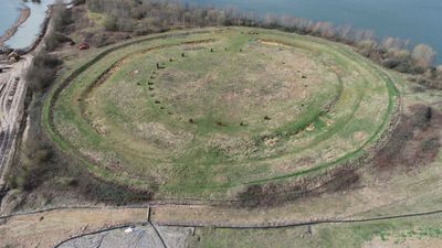
Devil's Quoits is a stone circle made of 28 conglomerate blocks arranged in a ring and surrounded by an earthen bank with an internal ditch running east to west. The structure creates a defined ceremonial space that stands out clearly in the open landscape.
The site dates back to the late Neolithic period, roughly 4000 to 5000 years ago, making it one of the region's oldest ceremonial structures. During World War II the area became an airfield, which disturbed the monument until restoration efforts began decades later.
The name comes from a local legend about the Devil playing quoits with a beggar for his soul and hurling stones to form the circle. This folklore remains part of the area's identity and adds layers of meaning to what visitors see today.
The site can be reached by following a gravel path that begins at the car park near the recycling bins south of the village. The walk is straightforward and offers open views of the monument from different angles once you arrive.
The entire monument underwent major reconstruction between 2002 and 2008, with stones from a nearby Ducklington quarry replacing missing original blocks to restore its original form. This modern restoration work allows visitors today to see the monument much as it would have appeared in ancient times.
The community of curious travelers
AroundUs brings together thousands of curated places, local tips, and hidden gems, enriched daily by 60,000 contributors worldwide.