Hart's Weir Footbridge

Log in to your account

AroundUs is a community-driven map of interesting places, built by curious explorers like you. It grows with every review, story, and photo you share.
Connect to save your favorite spots, contribute locations, and create personalized routes.
Continue with Google
Continue with Apple
Continue with X
Continue with Facebook
Continue with email
By continuing, you accept our Terms and Conditions and our Privacy Policy
Create an account

Hart's Weir Footbridge

Add to collection
Map
Suggest a change
Share

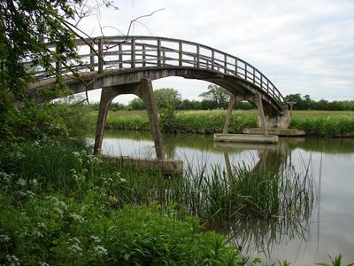
Hart's Weir Footbridge, Victorian footbridge over River Thames between Berkshire and Oxfordshire, United Kingdom.

Hart's Weir Footbridge is a pedestrian crossing over the River Thames that connects two riverside paths near Appleton village between Berkshire and Oxfordshire. The single-span structure allows walkers to safely cross the river and access the surrounding pathways.

The bridge was built in 1879 at the site of an earlier weir that carried different names throughout history. It replaced an older structure used to manage water flow along the Thames.

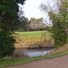
The bridge serves as a gathering point for people exploring the riverside paths and observing the local landscape. It connects two communities on opposite banks and provides a natural meeting place for those walking along the Thames.

The footbridge is located upstream from Northmoor Lock and can be easily accessed from nearby walking routes. Visitors should wear sturdy shoes as the riverside paths can be muddy or wet depending on the season.

When viewed from a distance, the bridge displays a distinctive curved shape that has inspired local residents to call it Rainbow Bridge in their everyday conversations. This affectionate nickname does not appear on official maps but lives on through word-of-mouth among the community.

Official opening: 1879

GPS coordinates: 51.70649,-1.39330

Latest update: December 14, 2025 16:46

Photos
Around this place
Devil's Quoits
United Kingdom

Devil's Quoits

3.8 km
New Bridge
United Kingdom

New Bridge

1.7 km
Northmoor Lock
United Kingdom

Northmoor Lock

1.5 km
St Giles' Church, Standlake
United Kingdom

St Giles' Church, Standlake

3.5 km
Church of St Mary
United Kingdom

Church of St Mary

3.9 km
Frilford Heath, Ponds and Fens
United Kingdom

Frilford Heath, Ponds and Fens

3.4 km
Church of St Lawrence
United Kingdom

Church of St Lawrence

2.4 km
Church of St Nicholas
United Kingdom

Church of St Nicholas

2.2 km
Church of St Lawrence, Appleton
United Kingdom

Church of St Lawrence, Appleton

2.4 km
Church of St Lawrence, Besselsleigh
United Kingdom

Church of St Lawrence, Besselsleigh

3.6 km
Church of St Denys
United Kingdom

Church of St Denys

1.8 km
Church of St John the Baptist
United Kingdom

Church of St John the Baptist

3.2 km
Milestone Approximately 20 Metres South East Of Church Of St Lawrence
United Kingdom

Milestone Approximately 20 Metres South East Of Church Of St Lawrence

2.4 km
The Blue Boar Public House
United Kingdom

The Blue Boar Public House

3.5 km
Appleton Manor
United Kingdom

Appleton Manor

2.4 km
Manor Farmhouse
United Kingdom

Manor Farmhouse

2.2 km
Milestone at SU 4485 9935
United Kingdom

Milestone at SU 4485 9935

3.3 km
The Manor House
United Kingdom

The Manor House

2.1 km
Kingston House
United Kingdom

Kingston House

3.4 km
Milestone Approximately 28 Metres West South West Of Crossways
United Kingdom

Milestone Approximately 28 Metres West South West Of Crossways

2.3 km
Longworth Manor, Wall And Gazebo 30 Metres East
United Kingdom

Longworth Manor, Wall And Gazebo 30 Metres East

4 km
Rectory Farm, Barn Approximately 60 Metres North North East Of Farmhouse
United Kingdom

Rectory Farm, Barn Approximately 60 Metres North North East Of Farmhouse

1.9 km
Rectory Farmhouse
United Kingdom

Rectory Farmhouse

1.8 km
Gazebo, Terrace Walls, Gates, Gatepiers And Wall Approximately 74 Metres North West Of Kingston House
United Kingdom

Gazebo, Terrace Walls, Gates, Gatepiers And Wall Approximately 74 Metres North West Of Kingston House

3.3 km
Milestone, Oakley House, between entrance to Park and Bothey Vineyard
United Kingdom

Milestone, Oakley House, between entrance to Park and Bothey Vineyard

4 km
Milestone, Tubney Farm, opp. church turn
United Kingdom

Milestone, Tubney Farm, opp. church turn

2.8 km
Milestone, Tubney Warren, 200m W of turn to Appleton (Oaksmere)
United Kingdom

Milestone, Tubney Warren, 200m W of turn to Appleton (Oaksmere)

2.8 km
Milestone, Faringdon Road; in front of shops
United Kingdom

Milestone, Faringdon Road; in front of shops

3.7 km
Show the full map
Reviews

Visited this place? Tap the stars to rate it and share your experience / photos with the community! Try now! You can cancel it anytime.

« Hart's Weir Footbridge - Victorian footbridge over River Thames between Berkshire and Oxfordshire, United Kingdom » is provided by Around Us (aroundus.com). Images and texts are derived from Wikimedia project under a Creative Commons license. You are allowed to copy, distribute, and modify copies of this page, under the conditions set by the license, as long as this note is clearly visible.

Discover hidden gems everywhere you go!

From secret cafés to breathtaking viewpoints, skip the crowded tourist spots and find places that match your style. Our app makes it easy with voice search, smart filtering, route optimization, and insider tips from travelers worldwide. Download now for the complete mobile experience.

Around Us App Screenshot

A unique approach to discovering new places

Le Figaro

All the places worth exploring

France Info

A tailor-made excursion in just a few clicks

20 Minutes