Enable Location

We need your location to show you interesting places around you

Discover nearby places

Find interesting locations and hidden gems around you

Precise directions

Get accurate directions and distances to places

Your location is never shared with other users. It's only used when you tap the location button.

Dalby Forest

Log in to your account

Start exploring — it's free

Trusted by 67,510 travelers worldwide

Continue with Google
Continue with Apple
or

We will send you a code to connect

By continuing, you accept our Terms and Conditions and our Privacy Policy

Check your inbox

We've sent a pincode in your inbox. Please enter the code below.

Dalby Forest
Discussion Reviews 1 Photos 1 Collections
10.6k Popularity

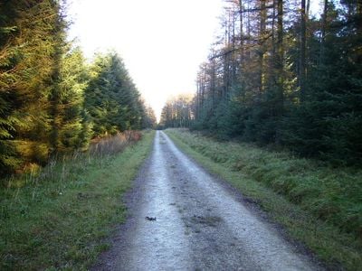
Dalby Forest, Managed forest in North Yorkshire, England

Dalby Forest is a managed woodland in North Yorkshire featuring a mix of coniferous and deciduous trees alongside open moorland and river valleys. The forest spans around 8,000 acres within the North York Moors National Park, creating a diverse landscape for exploration.

This land was once a Royal Hunting Forest called Pickering Forest before the Forestry Commission took over in 1919 and began replanting trees in 1921. That transformation into a managed woodland still shapes what you see when you visit today.

The area shows signs of human activity stretching back many centuries, visible as you walk through the trees. Ancient burial mounds and earthworks from the Bronze Age sit scattered among the woodland, telling stories of people who lived here long ago.

The forest offers more than 30 miles of marked cycling and walking paths at different difficulty levels threading through the woodland. You can pick up maps and guidance materials at the central visitor center to help you navigate and plan your time.

The location holds official recognition as a Dark Sky Discovery Site, meaning the night skies here are exceptionally dark for stargazing. This designation allows visitors to observe the stars in ways they cannot easily do elsewhere, regardless of the season.

The community of curious travelers

AroundUs brings together thousands of curated places, local tips, and hidden gems, enriched daily by 60,000 contributors worldwide.

Start exploring
Location
GPS coordinates
54.27800,-0.65400
Latest update
March 21, 2026 20:25
Yorkshire and the Humber : historic towns, national parks and northern coasts of England

Yorkshire and the Humber brings together different sides of northern England. York shows its medieval walls, narrow streets with timber houses, and a gothic cathedral. Leeds and Sheffield show their past as centers of industry, with old factories turned into museums and new neighborhoods. Hull,...

Around this place
United Kingdom

Warrening enclosure 1.07km east of High Rigg Farm

1.2 km
United Kingdom

Round cairn in Dalby Forest, 340m south of Jingleby Tower

1.6 km
United Kingdom

Round barrow 740m south west of Jingleby Tower

1.1 km
United Kingdom

Warrening enclosure on Flainsey Rigg, 1.45km east of Upper Dalby Wood

1.1 km
United Kingdom

Rabbit type on Flainsey Rigg, 1.3km east of Dalby Meadow

1.6 km
United Kingdom

Round barrow on Givendale Rigg, 1.6km south west of Givendale Head Farm

1.6 km
United Kingdom

Round barrow on Givendale Rigg, 1.5km south west of Givendale Head Farm

1.7 km
United Kingdom

Round barrow 250m south east of the Adder Stone

2.2 km
United Kingdom

Warrening enclosure 1.3km north west of Givendale Head Farm

403 m
United Kingdom

Three embanked pit alignments and segments of a linear boundary and a medieval hollow way, 300m west of Givendale Head Farm

1.3 km
United Kingdom

Warrening enclosure on Flainsey Rigg, 1.5km east of Low Dalby

817 m
United Kingdom

Round cairn 830m south west of Jingleby Tower

969 m
United Kingdom

Round barrow in Dalby Forest, 1100m south west of Jingleby Tower

660 m
United Kingdom

Part of a cross dyke with associated warrening features, 850m south east of High Rigg Farm

854 m
United Kingdom

Rabbit type on Sneverdale Rigg, 875m north east of Low Dalby House

1.5 km
United Kingdom

Round barrow in Dalby Forest, 220m north east of Jingleby Tower

2 km
United Kingdom

Round barrow on Newclose Rigg, 500m south west of Adder Stone

1.9 km
United Kingdom

Round barrow on Newclose Rigg, 380m south of Adder Stone

2 km
United Kingdom

Two round barrows 680m south west of Jingleby Tower

1.2 km
United Kingdom

Round cairn 280m south east of High Scamridge Farm

2.1 km
United Kingdom

Round barrow in Dalby Forest, 1190m south west of Jingleby Tower

584 m
United Kingdom

Round barrow 250m north of Givendale Head Farm

1.7 km
United Kingdom

Two round barrows on Newclose Rigg, 810m north east of High Rigg Farm

1.9 km
United Kingdom

Part of a warrening enclosure 470m south east of High Rigg Farm

1.2 km
United Kingdom

Round barrow on Newclose Rigg, 690m south west of Adder Stone

1.9 km
United Kingdom

Oxmoor and Givendale Dikes: prehistoric linear boundaries and associated features

1.8 km
United Kingdom

Section of linear boundary in Dalby Forest, 630m north west of Jingleby Tower

1.8 km
United Kingdom

Two intersecting linear boundaries in Dalby Forest, immediately west of Jingleby Tower

1.5 km
Show the full map
Reviews
Share your experience

No review yet

Discussions
Start a discussion...

No discussion yet

« Dalby Forest - Managed forest in North Yorkshire, England » is provided by Around Us (aroundus.com). Images and texts are derived from Wikimedia project under a Creative Commons license. You are allowed to copy, distribute, and modify copies of this page, under the conditions set by the license, as long as this note is clearly visible.

Discover hidden gems everywhere you go!

From secret cafés to breathtaking viewpoints, skip the crowded tourist spots and find places that match your style. Our app makes it easy with voice search, smart filtering, route optimization, and insider tips from travelers worldwide. Download now for the complete mobile experience.

Around Us App Screenshot

A unique approach to discovering new places

Le Figaro

All the places worth exploring

France Info

A tailor-made excursion in just a few clicks

20 Minutes

Around Us
Travel Guide & Maps
Download

Send to your phone

QR Code
1

Open the camera app on your mobile.

2

Point at the QR code with your camera. A notification will appear.

3

Tap the notification to open the link.