Battlesbury Camp, Iron Age contour fort in Warminster, England
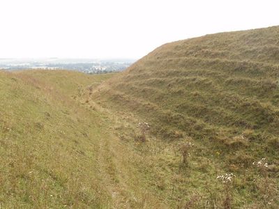
Battlesbury Camp is an Iron Age fortified settlement on a hilltop near Warminster, spanning approximately 23.5 acres and surrounded by three sets of ditches and ramparts. The fortification follows the natural contours of the land at roughly 208 meters elevation.
The fortification was occupied between 800 and 200 BC during the Iron Age and served as an important settlement hub. Excavations in the 1990s revealed over 170 ancient pits, 700 post holes, and evidence of craft and farming activities.
The settlement reflects Iron Age burial customs and ritual practices, with skeletal remains scattered in ditches suggesting beliefs about the treatment of the dead. Visitors can observe how these practices shaped the layout and use of space on the hillside.
The site is accessible on foot and the ancient ramparts and ditches remain clearly visible across the landscape. Visitors should wear sturdy shoes and be prepared for changing weather, particularly when wet ground becomes soft underfoot.
Rare Mediterranean coral beads discovered during excavations reveal that this settlement had connections with distant regions far beyond Britain. The find demonstrates that long-distance trade networks operated successfully during the Iron Age.
The community of curious travelers
AroundUs brings together thousands of curated places, local tips, and hidden gems, enriched daily by 60,000 contributors worldwide.