Enable Location

We need your location to show you interesting places around you

Discover nearby places

Find interesting locations and hidden gems around you

Precise directions

Get accurate directions and distances to places

Your location is never shared with other users. It's only used when you tap the location button.

Benson Lock

Log in to your account

Start exploring — it's free

Trusted by 61,431 travelers worldwide

Continue with Google
Continue with Apple
or

We will send you a code to connect

By continuing, you accept our Terms and Conditions and our Privacy Policy

Check your inbox

We've sent a pincode in your inbox. Please enter the code below.

Benson Lock

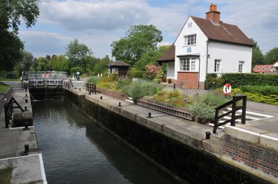
Benson Lock, Lock and footbridge on River Thames in Oxfordshire, England

Description

Benson Lock is a masonry lock with a footbridge spanning the River Thames in Oxfordshire. The structure regulates water levels to enable boats to pass through safely.

History

The original lock was built in 1788 by the Thames Navigation Commission as an oak structure. The current masonry version replaced it in 1870.

Culture

The lock draws people who enjoy watching boats navigate through the water while walking along the river path. It remains a natural gathering spot where visitors pause to observe the rhythm of river traffic.

Practical

The lock is accessible from the A4074 road, with limited parking available on nearby streets. Walking along the Thames Path provides the most enjoyable approach to the site.

Did you know?

This location marks the longest stretch between successive locks on the River Thames, spanning about 10 kilometers to the next one. This considerable distance makes it a significant waypoint for extended river journeys.

Location
GPS coordinates
51.61630,-1.11748
Latest update
December 13, 2025 12:41

AroundUs brings together thousands of curated places, local tips, and hidden gems, enriched daily by 60,000 contributors worldwide. Discover all places nearby (Oxfordshire).

Around this place
Wallingford Castle
United Kingdom

Wallingford Castle

1.5 km
Howbery Park
United Kingdom

Howbery Park

1.2 km
Church of St Helen
United Kingdom

Church of St Helen

534 m
South Cemetery Chapel
United Kingdom

South Cemetery Chapel

1.3 km
The Three Horseshoes Public House
United Kingdom

The Three Horseshoes Public House

685 m
North Cemetery Chapel
United Kingdom

North Cemetery Chapel

1.2 km
Town Arms Public House
United Kingdom

Town Arms Public House

1.7 km
The White Hart Hotel
United Kingdom

The White Hart Hotel

727 m
Benson Library
United Kingdom

Benson Library

688 m
Monument to Thomas Bennett in All Hallows Churchyard
United Kingdom

Monument to Thomas Bennett in All Hallows Churchyard

1.6 km
Number 100 And Attached Gateway
United Kingdom

Number 100 And Attached Gateway

1.7 km
St Nicholas And Attached Railings
United Kingdom

St Nicholas And Attached Railings

1.7 km
Remains Of St Nicholas's College
United Kingdom

Remains Of St Nicholas's College

1.6 km
Inn sign approximately 2 metres to South West of numbers 15 and 17 (The Castle Inn Public House)
United Kingdom

Inn sign approximately 2 metres to South West of numbers 15 and 17 (The Castle Inn Public House)

760 m
The Crown Hotel Public House And Barn
United Kingdom

The Crown Hotel Public House And Barn

1 km
The Round House
United Kingdom

The Round House

770 m
Milestone At Su 5977 9195
United Kingdom

Milestone At Su 5977 9195

1.6 km
Milestone Approximately 800 Metres South East Of Junction With A329
United Kingdom

Milestone Approximately 800 Metres South East Of Junction With A329

1.3 km
8 and 8B, Castle Street
United Kingdom

8 and 8B, Castle Street

1.7 km
Stable Block Approximately 110 Metres North East Of Hydraulics Research Limited
United Kingdom

Stable Block Approximately 110 Metres North East Of Hydraulics Research Limited

1.1 km
St Michael's House
United Kingdom

St Michael's House

1.7 km
92 And 93, High Street
United Kingdom

92 And 93, High Street

1.7 km
Lodge, Walls And Gates To Wallingford Cemetery
United Kingdom

Lodge, Walls And Gates To Wallingford Cemetery

1.2 km
Castle Farmhouse
United Kingdom

Castle Farmhouse

738 m
Fragment Of Castle Wall At Su 6096 8978
United Kingdom

Fragment Of Castle Wall At Su 6096 8978

1.4 km
420 Squadron RCAF Memorial, Wallingford
United Kingdom

420 Squadron RCAF Memorial, Wallingford

1.7 km
Monarchs Court
United Kingdom

Monarchs Court

787 m
Milestone, Oxford Road; at jct with Church Road, outside the Old Vicarage
United Kingdom

Milestone, Oxford Road; at jct with Church Road, outside the Old Vicarage

668 m
Show the full map
« Benson Lock - Lock and footbridge on River Thames in Oxfordshire, England » is provided by Around Us (aroundus.com). Images and texts are derived from Wikimedia project under a Creative Commons license. You are allowed to copy, distribute, and modify copies of this page, under the conditions set by the license, as long as this note is clearly visible.

Discover hidden gems everywhere you go!

From secret cafés to breathtaking viewpoints, skip the crowded tourist spots and find places that match your style. Our app makes it easy with voice search, smart filtering, route optimization, and insider tips from travelers worldwide. Download now for the complete mobile experience.

Around Us App Screenshot

A unique approach to discovering new places

Le Figaro

All the places worth exploring

France Info

A tailor-made excursion in just a few clicks

20 Minutes

Around Us
Travel Guide & Maps
Download

Send to your phone

QR Code
1

Open the camera app on your mobile.

2

Point at the QR code with your camera. A notification will appear.

3

Tap the notification to open the link.