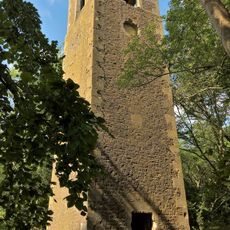
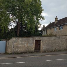
Browne's Folly, Stone folly tower in Bathford, England
Browne's Folly is a square stone tower standing on Farleigh Rise, built from coursed rubble stone with rounded-arch openings at its upper levels. The structure measures roughly 12 meters in height and displays the distinctive architectural style typical of 19th-century folly towers.
Colonel Wade Browne commissioned this tower in 1845 as a way to provide work during a period of agricultural hardship. The construction served both practical and charitable purposes for the local community facing economic difficulties.
The tower features in Bathford Parish Council's unofficial coat of arms, showing how deeply rooted it is in the community's identity. Local residents recognize it as a symbol connecting their neighborhood to its architectural past.
The structure has been cared for by the Folly Fellowship since 1998, but visitors should know the internal spiral staircase has deteriorated and lacks safety railings. Caution and awareness of the building's limitations are essential when exploring inside.
The surrounding area is a Site of Special Scientific Interest and contains one of Britain's oldest recorded Greater Horseshoe Bats, discovered in January 2000. This discovery makes the location significant for bat conservation and wildlife research.
GPS coordinates: 51.39450,-2.29891
Latest update: December 13, 2025 11:40
Bathampton Toll Bridge
2 km
Claverton Pumping Station
1.8 km
Browne's Folly
228 m
Monkton Farleigh Manor
1.5 km
Shockerwick House
812 m
Church of St Nicholas, Bathampton
1.6 km
Warleigh Weir
1.9 km
Hampton Rocks Cutting
1.5 km
Lock Up, Between Nos 22 And 24 Bathford Hill
840 m
Church of St Peter
1.6 km
Parish Church of St Swithun's
643 m
The George Inn Public House
1.6 km
The Kings Arms Inn
1.3 km
Warleigh Manor School
1.4 km
Fiveways House
1.7 km
Boundary Marker On (Ngr St 7844 6721)
1.3 km
Section Of Garden Wall 100 Yards To South East Of Batheaston House, Including Niche And Garden Seat
1.8 km
245 And 247, London Road East
1.6 km
Milestone At Ngr St 7851 6712
1.2 km
292, High Street
1.9 km
Milestone At Ngr St 8001 6675
890 m
Boundary Post On Box Bridge
1.7 km
Milestone At Ngr St 7898 6560
655 m
Boundary Walls And Garden Shed At Warleigh Point
457 m
Milestone At Ngr St 7854 6759
1.6 km
Garage, 15 Yards To East Of No 290, High Street
1.9 km
Manor Farmhouse With Outbuildings And Garage To West And Wall Surrounding Garden To North With Gatepiers
2 km
1-6, Canal Terrace
1.6 kmVisited this place? Tap the stars to rate it and share your experience / photos with the community! Try now! You can cancel it anytime.
Discover hidden gems everywhere you go!
From secret cafés to breathtaking viewpoints, skip the crowded tourist spots and find places that match your style. Our app makes it easy with voice search, smart filtering, route optimization, and insider tips from travelers worldwide. Download now for the complete mobile experience.
A unique approach to discovering new places❞
— Le Figaro
All the places worth exploring❞
— France Info
A tailor-made excursion in just a few clicks❞
— 20 Minutes