Enable Location

We need your location to show you interesting places around you

Discover nearby places

Find interesting locations and hidden gems around you

Precise directions

Get accurate directions and distances to places

Your location is never shared with other users. It's only used when you tap the location button.

Castle Caulfield

Log in to your account

Start exploring — it's free

Trusted by 62,474 travelers worldwide

Continue with Google
Continue with Apple
or

We will send you a code to connect

By continuing, you accept our Terms and Conditions and our Privacy Policy

Check your inbox

We've sent a pincode in your inbox. Please enter the code below.

Castle Caulfield

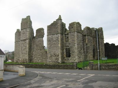
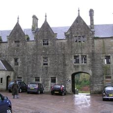
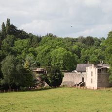
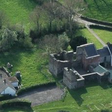
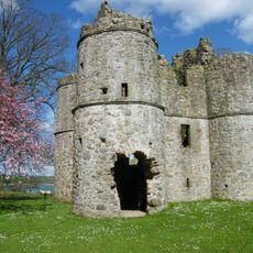
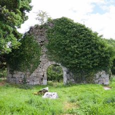
Castle Caulfield, Medieval castle ruins in Castlecaulfield, Northern Ireland.

Castle Caulfield is a three-story stone structure with thick walls, tall chimneys, and large windows typical of early modern fortified houses. The building displays architectural elements from the early 1600s and remains partially standing in County Tyrone's landscape.

The castle was built between 1611 and 1619 by Sir Toby Caulfeild to establish English control over land previously held by the O'Donnelly family. Its construction took place during the Ulster Plantation, a period of major settlement changes in the region.

The castle entrance displays the Caulfeild family coat of arms, representing the transition of power from Irish to English control in the region.

The ruins are protected as a state-care monument and can be visited with guided tours offering educational information about the site. Access is through the village of Castlecaulfield, and the location is open to visitors throughout the year.

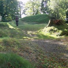
Scientific analysis reveals that a fortress stood on this site before 1282, centuries before the current structure was built. This suggests the location held strategic importance for defense across different historical periods.

The community of curious travelers

AroundUs brings together thousands of curated places, local tips, and hidden gems, enriched daily by 60,000 contributors worldwide.

Start exploring
GPS coordinates
54.50600,-6.83500
Latest update
December 8, 2025 21:00
Around this place
Tullyhogue Fort
United Kingdom

Tullyhogue Fort

13.6 km
Lissan House
United Kingdom

Lissan House

19.1 km
Charlemont Fort
United Kingdom

Charlemont Fort

12 km
Caledon House
United Kingdom

Caledon House

19.1 km
Peatlands Park
United Kingdom

Peatlands Park

14.8 km
Ardress House
United Kingdom

Ardress House

17.1 km
Parkanaur House
United Kingdom

Parkanaur House

1.9 km
Benburb Castle
United Kingdom

Benburb Castle

12.3 km
Mountjoy Castle
United Kingdom

Mountjoy Castle

15.8 km
Maghery Country Park
United Kingdom

Maghery Country Park

16.3 km
Patrician Hall
United Kingdom

Patrician Hall

17.3 km
Roughan Castle
United Kingdom

Roughan Castle

9.2 km
Ranfurly House
United Kingdom

Ranfurly House

4.3 km
Portal Tomb von Altcloghfin
United Kingdom

Portal Tomb von Altcloghfin

19 km
Errigal Truagh old church
Ireland

Errigal Truagh old church

16.4 km
The Argory
United Kingdom

The Argory

12.3 km
General Nicholson Statue Dungannon Royal School Dungannon Co.tyrone
United Kingdom

General Nicholson Statue Dungannon Royal School Dungannon Co.tyrone

4.5 km
St Mary's Roman Catholic Church 7 Cavanakeeran Road Pomeroy Dungannon Co Tyrone
United Kingdom

St Mary's Roman Catholic Church 7 Cavanakeeran Road Pomeroy Dungannon Co Tyrone

11.7 km
Dungannon Library
United Kingdom

Dungannon Library

4.2 km
Holy Trinity Roman Catholic Church Chapel Street Cookstown Bt80 8qb
United Kingdom

Holy Trinity Roman Catholic Church Chapel Street Cookstown Bt80 8qb

16.2 km
St. Michael's Church Clonoe Parish, Killary Glebe Coalisland, Co. Tyrone.
United Kingdom

St. Michael's Church Clonoe Parish, Killary Glebe Coalisland, Co. Tyrone.

12.6 km
Ravella Bridge
Ireland

Ravella Bridge

15.3 km
St Luran's Church Of Ireland Church 96 Church Street Cookstown Co Tyrone Bt80 8hx
United Kingdom

St Luran's Church Of Ireland Church 96 Church Street Cookstown Co Tyrone Bt80 8hx

15.7 km
Wellbrook Beetling Mill
United Kingdom

Wellbrook Beetling Mill

16.6 km
Former Bank of Ireland aka Ranfurly House 26 Market Square Dungannon, Co. Tyrone
United Kingdom

Former Bank of Ireland aka Ranfurly House 26 Market Square Dungannon, Co. Tyrone

4.3 km
St. Michael's Church Castlecaulfield Dungannon Co.tyrone
United Kingdom

St. Michael's Church Castlecaulfield Dungannon Co.tyrone

361 m
St. John's Church Church Hill Caledon Co.tyrone
United Kingdom

St. John's Church Church Hill Caledon Co.tyrone

17.1 km
St.james Church The Diamond Moy Dungannon Co. Tyrone
United Kingdom

St.james Church The Diamond Moy Dungannon Co. Tyrone

11.3 km
Show the full map
« Castle Caulfield - Medieval castle ruins in Castlecaulfield, Northern Ireland » is provided by Around Us (aroundus.com). Images and texts are derived from Wikimedia project under a Creative Commons license. You are allowed to copy, distribute, and modify copies of this page, under the conditions set by the license, as long as this note is clearly visible.

Discover hidden gems everywhere you go!

From secret cafés to breathtaking viewpoints, skip the crowded tourist spots and find places that match your style. Our app makes it easy with voice search, smart filtering, route optimization, and insider tips from travelers worldwide. Download now for the complete mobile experience.

Around Us App Screenshot

A unique approach to discovering new places

Le Figaro

All the places worth exploring

France Info

A tailor-made excursion in just a few clicks

20 Minutes

Around Us
Travel Guide & Maps
Download

Send to your phone

QR Code
1

Open the camera app on your mobile.

2

Point at the QR code with your camera. A notification will appear.

3

Tap the notification to open the link.