·

Enable Location

We need your location to show you interesting places around you

Discover nearby places

Find interesting locations and hidden gems around you

Precise directions

Get accurate directions and distances to places

Your location is never shared with other users. It's only used when you tap the location button.

Log in to your account

Start exploring — it's free

Trusted by 62,649 travelers worldwide

Continue with Google
Continue with Apple
or

We will send you a code to connect

By continuing, you accept our Terms and Conditions and our Privacy Policy

Check your inbox

We've sent a pincode in your inbox. Please enter the code below.

Colney Heath Mill

Colney Heath Mill, grade II listed windmill in the United kingdom

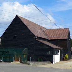
Colney Heath Mill is a windmill built in the mid-1800s in the village of Colney Heath, Hertfordshire. With four sails and three sets of grinding stones, it processed grain using wind power and later benefited from a steam engine when winds were light.

The mill was built around 1854 and ground grain for the community for over fifty years until it closed in 1906. William James was the last known miller to operate the property before the windmill ceased its working life.

The mill takes its name from its distinctive shape - a tall wooden structure with a rounded rotating cap. For visitors today, this design remains visible and serves as a tangible link to the craftsmanship of earlier times.

The building is now privately owned and serves as a residence, so interior access is not possible. The exterior can be admired from public paths, particularly the distinctive sails and rotating cap at the top.

In the late 20th century, the old mill was skillfully converted into a residence while preserving its original form and distinctive features. This adaptive reuse allowed the historic structure to be protected for future generations while providing modern living space.

The community of curious travelers

AroundUs brings together thousands of curated places, local tips, and hidden gems, enriched daily by 60,000 contributors worldwide.

Start exploring
Location
GPS coordinates
51.73479,-0.25663
Latest update
February 9, 2026 11:07
Around this place
De Havilland Aircraft Museum
United Kingdom

De Havilland Aircraft Museum

2.9 km
Tyttenhanger House
United Kingdom

Tyttenhanger House

1.6 km
Alban Way
United Kingdom

Alban Way

1.9 km
Water End Swallow Holes
United Kingdom

Water End Swallow Holes

2.8 km
Oxleys Wood
United Kingdom

Oxleys Wood

2.9 km
Church of St John the Evangelist
United Kingdom

Church of St John the Evangelist

2.1 km
The Woodman Inn
United Kingdom

The Woodman Inn

2.8 km
The Plough Inn
United Kingdom

The Plough Inn

1.5 km
Church of St Mark
United Kingdom

Church of St Mark

1.1 km
Church of St Peter
United Kingdom

Church of St Peter

2.8 km
Church of St Mary the Virgin
United Kingdom

Church of St Mary the Virgin

1.9 km
Main Gates,Octagonal Lodge,Walls,East Lodge And Service Gates To North Mymms Park
United Kingdom

Main Gates,Octagonal Lodge,Walls,East Lodge And Service Gates To North Mymms Park

2 km
Gaussen Tomb In Churchyard Of Church Of St Mary The Virgin
United Kingdom

Gaussen Tomb In Churchyard Of Church Of St Mary The Virgin

2 km
The Green Dragon Public House
United Kingdom

The Green Dragon Public House

2.9 km
The Golden Lion Public House
United Kingdom

The Golden Lion Public House

2.9 km
Telfords Bridge
United Kingdom

Telfords Bridge

2.9 km
Salisbury Hall
United Kingdom

Salisbury Hall

2.8 km
Mural Located In Former Lee Valley Water Company Offices And Free-Standing Sculpture On West Side Of Entrance Drive
United Kingdom

Mural Located In Former Lee Valley Water Company Offices And Free-Standing Sculpture On West Side Of Entrance Drive

2.7 km
The Old Maypole Public House
United Kingdom

The Old Maypole Public House

2.8 km
The Comet Public House
United Kingdom

The Comet Public House

3 km
The Bull Public House
United Kingdom

The Bull Public House

2.8 km
Milepost On North Side Of Road, South Of Oaklands College
United Kingdom

Milepost On North Side Of Road, South Of Oaklands College

2.9 km
1-5, High Street
United Kingdom

1-5, High Street

2.9 km
London Colney War Memorial
United Kingdom

London Colney War Memorial

2.9 km
North Mymms Park With Adjoining Garden Walls And Ha Ha
United Kingdom

North Mymms Park With Adjoining Garden Walls And Ha Ha

1.7 km
Milepost Approximately 70 Metres East North East Of The Three Horseshoes Public House
United Kingdom

Milepost Approximately 70 Metres East North East Of The Three Horseshoes Public House

2.4 km
Barn About 60 Metres North West Of Coursers Farm House
United Kingdom

Barn About 60 Metres North West Of Coursers Farm House

723 m
London Coal Duty Marker On South Side Of Road Near Telford's Bridge
United Kingdom

London Coal Duty Marker On South Side Of Road Near Telford's Bridge

2.9 km
Show the full map
« Colney Heath Mill - grade II listed windmill in the United kingdom » is provided by Around Us (aroundus.com). Images and texts are derived from Wikimedia project under a Creative Commons license. You are allowed to copy, distribute, and modify copies of this page, under the conditions set by the license, as long as this note is clearly visible.

Discover hidden gems everywhere you go!

From secret cafés to breathtaking viewpoints, skip the crowded tourist spots and find places that match your style. Our app makes it easy with voice search, smart filtering, route optimization, and insider tips from travelers worldwide. Download now for the complete mobile experience.

Around Us App Screenshot

A unique approach to discovering new places

Le Figaro

All the places worth exploring

France Info

A tailor-made excursion in just a few clicks

20 Minutes

Around Us
Travel Guide & Maps
Download

Send to your phone

QR Code
1

Open the camera app on your mobile.

2

Point at the QR code with your camera. A notification will appear.

3

Tap the notification to open the link.