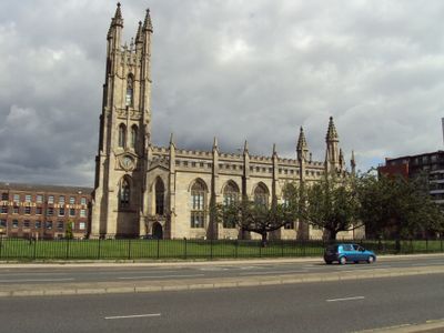
Church of St George, Chester Road, Hulme, Gothic Revival church in Hulme, Manchester, England
The Church of St George is a Gothic Revival building in Hulme distinguished by pointed arches, carved stone facades, and ornate detailing. The structure displays characteristic features of this style with soaring windows and vertical lines that draw the eye upward.
The building was designed by Francis Goodwin in 1828 when England experienced a revival of medieval architectural forms. Its construction reflected a time when Victorian architects deliberately drew from past traditions to shape new structures.
The name honours Saint George, a figure that held deep meaning for Victorian communities. The soaring windows and intricate interior details reveal how worshippers once experienced their faith through the building's design.
The building sits on Chester Road and is registered as a protected heritage site. Visitors should expect limited access since it is no longer used as an active church, so checking in advance is advisable.
The building was erected when Hulme was a prosperous residential area, with the church built as a sign of wealth and community values. The surroundings have changed dramatically, yet the structure itself continues to hold memory of that earlier period.
Location: Manchester
Inception: 1828
Architects: Francis Goodwin
Architectural style: Gothic Revival
GPS coordinates: 53.47210,-2.25930
Latest update: December 11, 2025 18:01
Manchester Liverpool Road railway station
572 m
Science and Industry Museum
589 m
Castlefield Viaduct
460 m
1830 warehouse, Liverpool Road railway station
598 m
Castlefield Congregational Chapel
501 m
Roman Catholic Church of St Wilfrid
542 m
North Pennine Ring
310 m
Hulme Barracks
536 m
Rochdale Canal Lock Number 92 And Castle Street Bridge
357 m
Commercial Hotel
542 m
Castlefield Gallery
562 m
Former Liverpool Road Railway Station Station Masters House
582 m
Merchants Warehouse
315 m
Latticework Viaducts, Castlefield
248 m
Railway Bridge Over Canal, The East Of Two At Sj 824 972
424 m
Middle Warehouse, At Former Castle Field Goods Yard
251 m
The Giants Basin
397 m
Boundary Stone On Knott Mill Bridge
508 m
Pair Of Culvert Arches Over River Medlock And Associated Overflow Channel
427 m
Bridgewater Canal Offices
310 m
Power Hall of Museum of Science and Industry
591 m
Railway Viaduct Linking Bridge Over Irwell To Liverpool Road Station
603 m
Former Canal Flour Mills
168 m
DOT Motorcycles Works, Ellesmere St
86 m
Castlefield Canal Basin
462 m
29-41, Liverpool Road
617 m
Former St Mathews Sunday School
566 m
123, Liverpool Road
542 mVisited this place? Tap the stars to rate it and share your experience / photos with the community! Try now! You can cancel it anytime.
Discover hidden gems everywhere you go!
From secret cafés to breathtaking viewpoints, skip the crowded tourist spots and find places that match your style. Our app makes it easy with voice search, smart filtering, route optimization, and insider tips from travelers worldwide. Download now for the complete mobile experience.
A unique approach to discovering new places❞
— Le Figaro
All the places worth exploring❞
— France Info
A tailor-made excursion in just a few clicks❞
— 20 Minutes