Enable Location

We need your location to show you interesting places around you

Discover nearby places

Find interesting locations and hidden gems around you

Precise directions

Get accurate directions and distances to places

Your location is never shared with other users. It's only used when you tap the location button.

Craster Tower

Log in to your account

Start exploring — it's free

Trusted by 62,922 travelers worldwide

Continue with Google
Continue with Apple
or

We will send you a code to connect

By continuing, you accept our Terms and Conditions and our Privacy Policy

Check your inbox

We've sent a pincode in your inbox. Please enter the code below.

Craster Tower
Discussion Reviews 1 Photos
2.8k Popularity

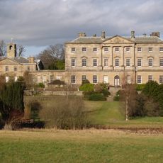
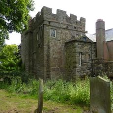
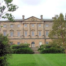
Craster Tower, Grade II* listed castle in Craster, England

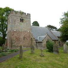
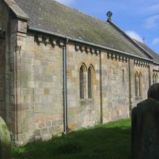
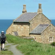
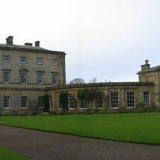
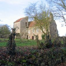
Craster Tower is a fortified medieval tower house from the 14th century with walls about 2 meters (6 feet) thick and vaulted ceilings that support the structure. In the 18th century, a five-part Georgian mansion was added, giving the ensemble its distinctive appearance today.

The Craster family received permission to build the tower house in the late 14th century, and it was documented in a 1415 survey of border strongholds. After centuries of use and decline, the property was repurchased and restored by Oswin Craster and his cousins in 1965.

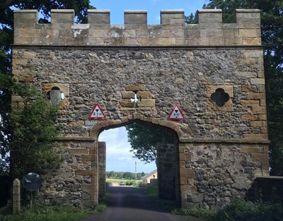
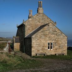
The Craster family name is deeply rooted in this place, and their influence shaped the property over many centuries. You can see how medieval and Georgian architecture sit side by side, telling the different stories of the building's past.

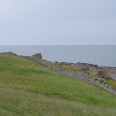
The building is now divided into three residential apartments and sits in a quiet rural village on England's east coast. Wear appropriate footwear as the grounds and interior may have uneven surfaces from the age of the structures.

The original tower had four stories but was reduced to three in the 18th century to allow for higher ceilings during Georgian renovations. This change shows how medieval structures were adapted to suit newer living standards and tastes.

The community of curious travelers

AroundUs brings together thousands of curated places, local tips, and hidden gems, enriched daily by 60,000 contributors worldwide.

Start exploring
Location
GPS coordinates
55.46930,-1.60427
Latest update
December 8, 2025 21:06
Around this place
Dunstanburgh Castle
United Kingdom

Dunstanburgh Castle

2.2 km
Howick Hall
United Kingdom

Howick Hall

2.1 km
Howick house
United Kingdom

Howick house

1.8 km
Embleton Tower
United Kingdom

Embleton Tower

3.5 km
Church of St Michael and All Angels
United Kingdom

Church of St Michael and All Angels

2.2 km
Church of the Holy Trinity, Embleton
United Kingdom

Church of the Holy Trinity, Embleton

3.6 km
Longhoughton Quarry
United Kingdom

Longhoughton Quarry

4.8 km
Church of Saints Peter and Paul
United Kingdom

Church of Saints Peter and Paul

4.5 km
Church of Saints Philip and James
United Kingdom

Church of Saints Philip and James

4.9 km
Embleton United Reformed Church
United Kingdom

Embleton United Reformed Church

3.6 km
St Peter the Fisherman
United Kingdom

St Peter the Fisherman

724 m
Village Pump
United Kingdom

Village Pump

3.6 km
Signpost At Road Junction South Of Rock Farm
United Kingdom

Signpost At Road Junction South Of Rock Farm

4.7 km
The Bathing House
United Kingdom

The Bathing House

2.3 km
Outbuilding South West Of The Bathing House
United Kingdom

Outbuilding South West Of The Bathing House

2.3 km
Defended settlement, 600m south east of Red Stead
United Kingdom

Defended settlement, 600m south east of Red Stead

3.3 km
Howick Hall Centre Block And Link Galleries
United Kingdom

Howick Hall Centre Block And Link Galleries

2.1 km
Mile Post 400 Metres South Of Renington South East Farm
United Kingdom

Mile Post 400 Metres South Of Renington South East Farm

4.2 km
Wall And Steps To East Of The Bathing House
United Kingdom

Wall And Steps To East Of The Bathing House

2.3 km
Signpost At Juntion With Station Road
United Kingdom

Signpost At Juntion With Station Road

4.7 km
Gateway Spanning Road To North Of Craster Tower
United Kingdom

Gateway Spanning Road To North Of Craster Tower

97 m
Mile Post 700 Metres North Of Prickly Bridge
United Kingdom

Mile Post 700 Metres North Of Prickly Bridge

4.5 km
Road Bridge And Footbridge 320 Metres South East Of Howick Hall
United Kingdom

Road Bridge And Footbridge 320 Metres South East Of Howick Hall

2.3 km
Stableyard Buildings At East End Of Howick Hall
United Kingdom

Stableyard Buildings At East End Of Howick Hall

2 km
Dunstan Hall
United Kingdom

Dunstan Hall

618 m
Howick Hall West Wing
United Kingdom

Howick Hall West Wing

2.1 km
Dovecote at rear of Number 4
United Kingdom

Dovecote at rear of Number 4

3.3 km
Old Limekiln At Harlaw Hill Waste Disposal Site
United Kingdom

Old Limekiln At Harlaw Hill Waste Disposal Site

5 km
Show the full map
Reviews
Share your experience

No review yet

Discussions
Start a discussion...

No discussion yet

« Craster Tower - Grade II* listed castle in Craster, England » is provided by Around Us (aroundus.com). Images and texts are derived from Wikimedia project under a Creative Commons license. You are allowed to copy, distribute, and modify copies of this page, under the conditions set by the license, as long as this note is clearly visible.

Discover hidden gems everywhere you go!

From secret cafés to breathtaking viewpoints, skip the crowded tourist spots and find places that match your style. Our app makes it easy with voice search, smart filtering, route optimization, and insider tips from travelers worldwide. Download now for the complete mobile experience.

Around Us App Screenshot

A unique approach to discovering new places

Le Figaro

All the places worth exploring

France Info

A tailor-made excursion in just a few clicks

20 Minutes

Around Us
Travel Guide & Maps
Download

Send to your phone

QR Code
1

Open the camera app on your mobile.

2

Point at the QR code with your camera. A notification will appear.

3

Tap the notification to open the link.