Enable Location

We need your location to show you interesting places around you

Discover nearby places

Find interesting locations and hidden gems around you

Precise directions

Get accurate directions and distances to places

Your location is never shared with other users. It's only used when you tap the location button.

Howick house

Log in to your account

Save your favorite places
Create custom travel routes
Rate and review places
Access the full interactive map
Continue with Google
Continue with Apple
Continue with email
By continuing, you accept our Terms and Conditions and our Privacy Policy
Create an account
Add to collection
Map
Suggest a change
Share

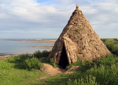
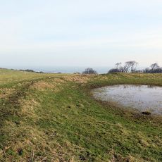
Howick house, Archaeological site in Northumberland, England.

Howick House is a Mesolithic round dwelling with deep post holes, multiple hearths, and clear evidence of permanent occupation near the Northumberland coast. Two reconstructions display the building technique used: birch poles formed a cone shape, with pine logs providing the structural framework.

The site originated around 7800 BC, ranking among the earliest known permanent settlements from Britain's Stone Age. Examination of charred hazelnut shells indicates the location was continuously occupied for roughly 100 years.

The residents took advantage of their coastal setting by fishing and gathering shellfish, while also collecting hazelnuts and berries from nearby areas. This combination of sea and land resources allowed them to remain in one place rather than moving constantly.

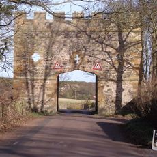
The two reconstructions on-site help visitors understand how the original structure looked and how it was built. Wear good footwear, as the coastal location can be windy and the ground is uneven in places.

Analysis of over 30 charred hazelnut shells using radiocarbon dating provided unusually detailed information about the site's settlement history. This method allowed archaeologists to build a far more precise picture of human occupation than typically possible.

Location: Northumberland

GPS coordinates: 55.45400,-1.59300

Latest update: December 8, 2025 19:58

Photos
Around this place
Dunstanburgh Castle
United Kingdom

Dunstanburgh Castle

3.8 km
Howick Hall
United Kingdom

Howick Hall

1.1 km
Craster Tower
United Kingdom

Craster Tower

1.8 km
The Observatory
United Kingdom

The Observatory

4.7 km
Church of St Michael and All Angels
United Kingdom

Church of St Michael and All Angels

1.1 km
Longhoughton Quarry
United Kingdom

Longhoughton Quarry

3.8 km
Church of Saints Peter and Paul
United Kingdom

Church of Saints Peter and Paul

3.2 km
St Peter the Fisherman
United Kingdom

St Peter the Fisherman

2 km
Church of St Mary
United Kingdom

Church of St Mary

6.5 km
Aln Viaduct, Lesbury
United Kingdom

Aln Viaduct, Lesbury

6.5 km
The Old Vicarage
United Kingdom

The Old Vicarage

6.5 km
Outbuilding South West Of The Bathing House
United Kingdom

Outbuilding South West Of The Bathing House

491 m
The Bathing House
United Kingdom

The Bathing House

482 m
Defended settlement, 600m south east of Red Stead
United Kingdom

Defended settlement, 600m south east of Red Stead

1.6 km
Dunstan Hall
United Kingdom

Dunstan Hall

2.5 km
Garden Wall To West Of Boulmer Hall
United Kingdom

Garden Wall To West Of Boulmer Hall

3.5 km
Wall And Gate Piers In Front Of The Old Vicarage
United Kingdom

Wall And Gate Piers In Front Of The Old Vicarage

6.5 km
Signpost At Juntion With Station Road
United Kingdom

Signpost At Juntion With Station Road

3.3 km
Howick Hall West Wing
United Kingdom

Howick Hall West Wing

1.1 km
Wall And Steps To East Of The Bathing House
United Kingdom

Wall And Steps To East Of The Bathing House

457 m
Mile Post 400 Metres South Of Renington South East Farm
United Kingdom

Mile Post 400 Metres South Of Renington South East Farm

4.6 km
Milepost 300 Metres North Of Denwick Lane End
United Kingdom

Milepost 300 Metres North Of Denwick Lane End

4.9 km
Stable And Attached Yard Walls To North Of The Old Vicarage
United Kingdom

Stable And Attached Yard Walls To North Of The Old Vicarage

6.5 km
Road Bridge And Footbridge 320 Metres South East Of Howick Hall
United Kingdom

Road Bridge And Footbridge 320 Metres South East Of Howick Hall

993 m
Gateway Spanning Road To North Of Craster Tower
United Kingdom

Gateway Spanning Road To North Of Craster Tower

1.9 km
Stableyard Buildings At East End Of Howick Hall
United Kingdom

Stableyard Buildings At East End Of Howick Hall

1.1 km
Howick Hall Centre Block And Link Galleries
United Kingdom

Howick Hall Centre Block And Link Galleries

1.1 km
Old Limekiln At Harlaw Hill Waste Disposal Site
United Kingdom

Old Limekiln At Harlaw Hill Waste Disposal Site

4.5 km
Show the full map
Reviews

Visited this place? Tap the stars to rate it and share your experience / photos with the community! Try now! You can cancel it anytime.

« Howick house - Archaeological site in Northumberland, England » is provided by Around Us (aroundus.com). Images and texts are derived from Wikimedia project under a Creative Commons license. You are allowed to copy, distribute, and modify copies of this page, under the conditions set by the license, as long as this note is clearly visible.

Discover hidden gems everywhere you go!

From secret cafés to breathtaking viewpoints, skip the crowded tourist spots and find places that match your style. Our app makes it easy with voice search, smart filtering, route optimization, and insider tips from travelers worldwide. Download now for the complete mobile experience.

Around Us App Screenshot

A unique approach to discovering new places

Le Figaro

All the places worth exploring

France Info

A tailor-made excursion in just a few clicks

20 Minutes