Craster

Log in to your account

AroundUs is a community-driven map of interesting places, built by curious explorers like you. It grows with every review, story, and photo you share.
Connect to save your favorite spots, contribute locations, and create personalized routes.
Continue with Google
Continue with Apple
Continue with X
Continue with Facebook
Continue with email
By continuing, you accept our Terms and Conditions and our Privacy Policy
Create an account
Add to collection
Map
Suggest a change
Share

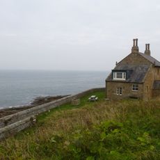
Craster, Fishing village in Northumberland, England

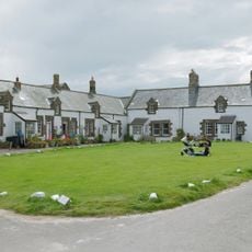
Craster is a fishing village on the North Sea coast with a stone harbor and traditional buildings clustered around the water's edge. The settlement centers on the harbor area, where fishing remains an active part of daily life.

The harbor was built in the early 1900s as a memorial to Captain Charles Craster, a local figure who died on an expedition. The harbor's construction transformed the settlement into an important fishing center on the northeast coast.

The village has long been known for its smoked herring, particularly the kippers produced here using traditional techniques. This craft remains central to how locals and visitors understand the place.

The village is accessible by bus from nearby towns and has parking near the harbor entrance. The settlement is compact and easy to walk through, especially around the harbor and fishing facilities.

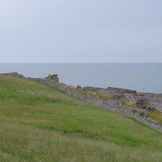
The harbor contains remains of industrial silos that once stored crushed rock from local quarries for export by coastal vessels. These structures hint at an earlier economic activity that shaped the harbor's layout and purpose.

Location: Northumberland

GPS coordinates: 55.47208,-1.59284

Latest update: December 7, 2025 20:20

Photos
Around this place
Dunstanburgh Castle
United Kingdom

Dunstanburgh Castle

1.8 km
Howick Hall
United Kingdom

Howick Hall

2.6 km
Howick house
United Kingdom

Howick house

2 km
Craster Tower
United Kingdom

Craster Tower

785 m
Embleton Tower
United Kingdom

Embleton Tower

3.8 km
Church of St Michael and All Angels
United Kingdom

Church of St Michael and All Angels

2.7 km
Church of the Holy Trinity, Embleton
United Kingdom

Church of the Holy Trinity, Embleton

3.8 km
Embleton United Reformed Church
United Kingdom

Embleton United Reformed Church

3.8 km
Church of Saints Philip and James
United Kingdom

Church of Saints Philip and James

5.6 km
Ship Inn
United Kingdom

Ship Inn

5 km
St Peter the Fisherman
United Kingdom

St Peter the Fisherman

70 m
Village Pump
United Kingdom

Village Pump

3.8 km
Outbuilding South West Of The Bathing House
United Kingdom

Outbuilding South West Of The Bathing House

2.4 km
The Bathing House
United Kingdom

The Bathing House

2.4 km
Signpost At Road Junction South Of Rock Farm
United Kingdom

Signpost At Road Junction South Of Rock Farm

5.4 km
Defended settlement, 600m south east of Red Stead
United Kingdom

Defended settlement, 600m south east of Red Stead

3.6 km
Howick Hall Centre Block And Link Galleries
United Kingdom

Howick Hall Centre Block And Link Galleries

2.6 km
Mile Post 400 Metres South Of Renington South East Farm
United Kingdom

Mile Post 400 Metres South Of Renington South East Farm

5 km
Wall And Steps To East Of The Bathing House
United Kingdom

Wall And Steps To East Of The Bathing House

2.4 km
Gateway Spanning Road To North Of Craster Tower
United Kingdom

Gateway Spanning Road To North Of Craster Tower

792 m
Nos 1 And 2 And Garage Adjacent To Ship Inn
United Kingdom

Nos 1 And 2 And Garage Adjacent To Ship Inn

5 km
Mile Post 700 Metres North Of Prickly Bridge
United Kingdom

Mile Post 700 Metres North Of Prickly Bridge

4.9 km
Former Goods Shed On East Of Railway Immediately North Of B 1340
United Kingdom

Former Goods Shed On East Of Railway Immediately North Of B 1340

5.5 km
Stableyard Buildings At East End Of Howick Hall
United Kingdom

Stableyard Buildings At East End Of Howick Hall

2.5 km
Road Bridge And Footbridge 320 Metres South East Of Howick Hall
United Kingdom

Road Bridge And Footbridge 320 Metres South East Of Howick Hall

2.7 km
Dunstan Hall
United Kingdom

Dunstan Hall

1 km
Howick Hall West Wing
United Kingdom

Howick Hall West Wing

2.6 km
Dovecote at rear of Number 4
United Kingdom

Dovecote at rear of Number 4

3.5 km
Show the full map
Reviews

Visited this place? Tap the stars to rate it and share your experience / photos with the community! Try now! You can cancel it anytime.

« Craster - Fishing village in Northumberland, England » is provided by Around Us (aroundus.com). Images and texts are derived from Wikimedia project under a Creative Commons license. You are allowed to copy, distribute, and modify copies of this page, under the conditions set by the license, as long as this note is clearly visible.

Discover hidden gems everywhere you go!

From secret cafés to breathtaking viewpoints, skip the crowded tourist spots and find places that match your style. Our app makes it easy with voice search, smart filtering, route optimization, and insider tips from travelers worldwide. Download now for the complete mobile experience.

Around Us App Screenshot

A unique approach to discovering new places

Le Figaro

All the places worth exploring

France Info

A tailor-made excursion in just a few clicks

20 Minutes