Enable Location

We need your location to show you interesting places around you

Discover nearby places

Find interesting locations and hidden gems around you

Precise directions

Get accurate directions and distances to places

Your location is never shared with other users. It's only used when you tap the location button.

Gosforth House

Log in to your account

Start exploring — it's free

Trusted by 62,562 travelers worldwide

Continue with Google
Continue with Apple
or

We will send you a code to connect

By continuing, you accept our Terms and Conditions and our Privacy Policy

Check your inbox

We've sent a pincode in your inbox. Please enter the code below.

Gosforth House

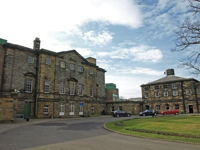
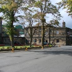
Gosforth House, English country house in Tyne and Wear, England

Gosforth House is a Grade II listed country house from the mid-1700s with classical architectural features and expansive gardens surrounding the building. Today it operates as a conference and events facility that hosts meetings and celebrations within the historic structure.

The mansion was built between 1755 and 1764 by architect James Paine for the Brandling family. In 1914, suffragettes set a fire inside as part of their campaign demanding voting rights for women.

The house showcases classical design elements that remain visible in its rooms and grounds today. These spaces reflect how prosperous families of the period lived and arranged their estates to display their status.

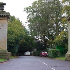
The location sits within the racecourse grounds and is today primarily accessible to visitors during events and conferences held there. It is advisable to check in advance what visiting opportunities and scheduled activities are available when planning a visit.

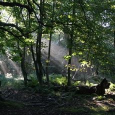
An artificial lake was created as a notable feature of the original landscape design surrounding the house. This water feature was deliberately engineered as part of the estate's visual composition within the wider grounds.

The community of curious travelers

AroundUs brings together thousands of curated places, local tips, and hidden gems, enriched daily by 60,000 contributors worldwide.

Start exploring
Location
GPS coordinates
55.03500,-1.61300
Latest update
December 14, 2025 11:01
Around this place
Tyneview Park
United Kingdom

Tyneview Park

2.9 km
Gosforth Park Nature Reserve
United Kingdom

Gosforth Park Nature Reserve

813 m
Partnership House
United Kingdom

Partnership House

2.8 km
Burradon Tower
United Kingdom

Burradon Tower

3.3 km
British Gas Research Station Including Attached Restaurant Block To South
United Kingdom

British Gas Research Station Including Attached Restaurant Block To South

2 km
Sacred Heart Church, North Gosforth
United Kingdom

Sacred Heart Church, North Gosforth

810 m
Gosforth Central Park
United Kingdom

Gosforth Central Park

3.2 km
1914-18 War Memorial In St Bartholomew's Churchyard, Longbenton
United Kingdom

1914-18 War Memorial In St Bartholomew's Churchyard, Longbenton

3.5 km
Church of St John the Evangelist
United Kingdom

Church of St John the Evangelist

3.1 km
Church of St Nicholas
United Kingdom

Church of St Nicholas

3.2 km
Roman Catholic Church of St Charles, Attached Presbytery and Boundary Wall to South and South West
United Kingdom

Roman Catholic Church of St Charles, Attached Presbytery and Boundary Wall to South and South West

3.1 km
North Gosforth Chapel
United Kingdom

North Gosforth Chapel

1.1 km
Milestone About 150 Metres South Of Church Of Sacred Heart
United Kingdom

Milestone About 150 Metres South Of Church Of Sacred Heart

805 m
Entrance Gate Piers To Brandling House And Adjoining Park Walls
United Kingdom

Entrance Gate Piers To Brandling House And Adjoining Park Walls

671 m
Border Minstrel
United Kingdom

Border Minstrel

56 m
Globe Cinema
United Kingdom

Globe Cinema

3.1 km
Gosforth War Memorial Pillar
United Kingdom

Gosforth War Memorial Pillar

3.3 km
St Aidans
United Kingdom

St Aidans

1.3 km
Dial Cottage
United Kingdom

Dial Cottage

2.8 km
Gosforth Library
United Kingdom

Gosforth Library

2.8 km
Main Dike Stone
United Kingdom

Main Dike Stone

3 km
Salters' Bridge
United Kingdom

Salters' Bridge

2.8 km
Milepost, Wideopen
United Kingdom

Milepost, Wideopen

2.3 km
Caretaker's Flat, Brandling House
United Kingdom

Caretaker's Flat, Brandling House

70 m
Gosforth House, Now Brandling House, Part Of High Gosforth Park Club
United Kingdom

Gosforth House, Now Brandling House, Part Of High Gosforth Park Club

29 m
Milepost, Great North Road, by Gosforth Central Middle School field
United Kingdom

Milepost, Great North Road, by Gosforth Central Middle School field

2.7 km
Milepost, Great North Road, Brunton Park
United Kingdom

Milepost, Great North Road, Brunton Park

1 km
Milepost, Great North Road
United Kingdom

Milepost, Great North Road

2.1 km
Show the full map
« Gosforth House - English country house in Tyne and Wear, England » is provided by Around Us (aroundus.com). Images and texts are derived from Wikimedia project under a Creative Commons license. You are allowed to copy, distribute, and modify copies of this page, under the conditions set by the license, as long as this note is clearly visible.

Discover hidden gems everywhere you go!

From secret cafés to breathtaking viewpoints, skip the crowded tourist spots and find places that match your style. Our app makes it easy with voice search, smart filtering, route optimization, and insider tips from travelers worldwide. Download now for the complete mobile experience.

Around Us App Screenshot

A unique approach to discovering new places

Le Figaro

All the places worth exploring

France Info

A tailor-made excursion in just a few clicks

20 Minutes

Around Us
Travel Guide & Maps
Download

Send to your phone

QR Code
1

Open the camera app on your mobile.

2

Point at the QR code with your camera. A notification will appear.

3

Tap the notification to open the link.