British Gas Research Station Including Attached Restaurant Block To South

Log in to your account

AroundUs is a community-driven map of interesting places, built by curious explorers like you. It grows with every review, story, and photo you share.
Connect to save your favorite spots, contribute locations, and create personalized routes.
By continuing, you accept our Terms and Conditions and our Privacy Policy

British Gas Research Station Including Attached Restaurant Block To South

Add to collection
Map
Suggest a change
Share

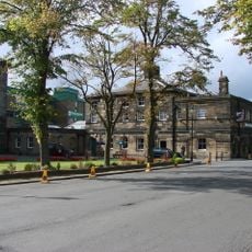
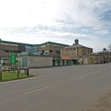
British Gas Research Station Including Attached Restaurant Block To South, Grade II* listed research building in Killingworth, United Kingdom

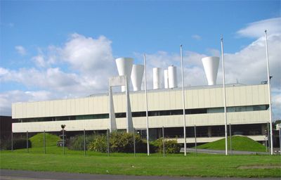
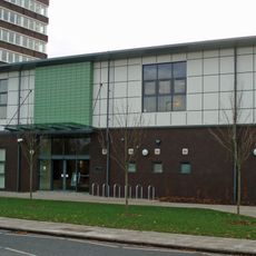
The British Gas Research Station is a reinforced concrete building with three floors in Killingworth, expanded in the 1970s with an attached restaurant wing. The complex houses research areas, workshops, and teaching spaces designed for engineering work and training.

Built in 1967 on the site of the former Killingworth Colliery, the building served as the main research hub for British Gas until 1995. It marks the shift of the location from mining to energy research activities.

The architecture firm Ryder & Yates incorporated modernist design principles influenced by Le Corbusier when creating this engineering research establishment in the 1960s.

The building sits along Station Road in North Tyneside and can be reached by public paths, though public visiting options are limited. Check in advance whether access is possible and how to best approach the site.

The front facade displays intentionally asymmetrical architectural elements that set it apart from other industrial buildings of its era. This design choice reflected modernist principles applied by the architects Ryder and Yates.

Location: North Tyneside

Inception: 1967

GPS coordinates: 55.03650,-1.58149

Latest update: December 14, 2025 18:07

Photos
Around this place
Tyneview Park
United Kingdom

Tyneview Park

2.5 km
Gosforth Park Nature Reserve
United Kingdom

Gosforth Park Nature Reserve

1.5 km
Partnership House
United Kingdom

Partnership House

4 km
Gosforth House
United Kingdom

Gosforth House

2 km
St Bartholomew's Church, Long Benton
United Kingdom

St Bartholomew's Church, Long Benton

2.4 km
Burradon Tower
United Kingdom

Burradon Tower

1.8 km
Sacred Heart Church, North Gosforth
United Kingdom

Sacred Heart Church, North Gosforth

2.6 km
1914-18 War Memorial In St Bartholomew's Churchyard, Longbenton
United Kingdom

1914-18 War Memorial In St Bartholomew's Churchyard, Longbenton

2.4 km
Church of St Nicholas
United Kingdom

Church of St Nicholas

3.8 km
Church of St John the Evangelist
United Kingdom

Church of St John the Evangelist

1.2 km
Roman Catholic Church of St Charles, Attached Presbytery and Boundary Wall to South and South West
United Kingdom

Roman Catholic Church of St Charles, Attached Presbytery and Boundary Wall to South and South West

4 km
Backworth War Memorial
United Kingdom

Backworth War Memorial

3.3 km
North Gosforth Chapel
United Kingdom

North Gosforth Chapel

2.6 km
Milestone About 150 Metres South Of Church Of Sacred Heart
United Kingdom

Milestone About 150 Metres South Of Church Of Sacred Heart

2.6 km
Entrance Gate Piers To Brandling House And Adjoining Park Walls
United Kingdom

Entrance Gate Piers To Brandling House And Adjoining Park Walls

2.7 km
Border Minstrel
United Kingdom

Border Minstrel

2 km
St Aidans
United Kingdom

St Aidans

3.1 km
Dial Cottage
United Kingdom

Dial Cottage

1.2 km
Backworth Miners Welfare Hall
United Kingdom

Backworth Miners Welfare Hall

3.3 km
Gosforth Library
United Kingdom

Gosforth Library

3.9 km
Main Dike Stone
United Kingdom

Main Dike Stone

3.6 km
Salters' Bridge
United Kingdom

Salters' Bridge

3.2 km
Milepost, Wideopen
United Kingdom

Milepost, Wideopen

3.4 km
Milepost At Junction Of Front Street And Manorfields
United Kingdom

Milepost At Junction Of Front Street And Manorfields

2.9 km
Caretaker's Flat, Brandling House
United Kingdom

Caretaker's Flat, Brandling House

2 km
Gosforth House, Now Brandling House, Part Of High Gosforth Park Club
United Kingdom

Gosforth House, Now Brandling House, Part Of High Gosforth Park Club

2 km
Milepost, Great North Road, by Gosforth Central Middle School field
United Kingdom

Milepost, Great North Road, by Gosforth Central Middle School field

3.8 km
Milepost, Great North Road
United Kingdom

Milepost, Great North Road

3.4 km
Show the full map
Reviews

Visited this place? Tap the stars to rate it and share your experience / photos with the community! Try now! You can cancel it anytime.

« British Gas Research Station Including Attached Restaurant Block To South - Grade II* listed research building in Killingworth, United Kingdom » is provided by Around Us (aroundus.com). Images and texts are derived from Wikimedia project under a Creative Commons license. You are allowed to copy, distribute, and modify copies of this page, under the conditions set by the license, as long as this note is clearly visible.

Discover hidden gems everywhere you go!

From secret cafés to breathtaking viewpoints, skip the crowded tourist spots and find places that match your style. Our app makes it easy with voice search, smart filtering, route optimization, and insider tips from travelers worldwide. Download now for the complete mobile experience.

Around Us App Screenshot

A unique approach to discovering new places

Le Figaro

All the places worth exploring

France Info

A tailor-made excursion in just a few clicks

20 Minutes